
Nasty weekend coastal storm could dump up to 4″ of rain on NJ
The Bottom Line
There are two big weather stories affecting New Jersey through the rest of the week.
Cold air has returned, making for an unseasonably chilly Thursday and Friday. With a brisk wind, of course. It is going to feel more like Valentine's Day or Christmas, rather than springtime late March.
Even more impactful will be a coastal storm system — yes, you can call it a nor'easter if you want — set to soak NJ for a period of 24 hours from late Friday night through Saturday. Steady to heavy rain will not let up much during Saturday's daytime hours. Gusty winds and coastal flooding are expected too.

Thursday
The good news: Thursday will be sunny and completely dry. The bad news: It's cold.
We are starting the day with temperatures on either side of 30 degrees. Not unheard of at this point of the year — and we have many more subfreezing mornings coming up.
Highs Thursday afternoon will only reach the lower 40s. That is about 10 degrees below normal for this time of year. This will be the coldest day of the week.
A brisk wind will gust to about 25 mph throughout the day too, adding a bite to that cold air. Better bundle up as you would in the middle of February, as that will be the overall vibe.
One more important note: Believe it or not, the wildfire danger will be elevated Thursday. Yes, we've had a lot of rain recently. But the "fuel," the brush and leaves and grass, has dried out now. Add very low humidity and gusty winds, and Smokey Bear starts to get worried. Outdoor burning is a very bad idea here — one little spark, one flicked cigarette can lead to a disaster in these conditions.
The wicked, whipping wind will finally calm down Thursday evening. And it will be clear and freezing cold overnight. My latest forecast puts lows in the mid 20s — once again, a freeze for the vast majority of the state.
Friday
Friday will be slightly better than Thursday — a couple degrees warmer, and not as windy. While the daytime hours will stay dry, raindrops will come into view late Friday night.
High temperatures on Friday should aim for the mid 40s — still on the cool side of normal. Skies will progress from sunshine to clouds through the afternoon.
I do not see initial rain showers threatening New Jersey until about 10 p.m. Friday evening, at the earliest.
Saturday
—Timeline... Steady to heavy rain is likely from early morning through Saturday evening. There may be some brief breaks in the wet weather, especially in the afternoon. But I doubt it will be enough to salvage your outdoor plans. It looks like a washout, a nasty day from start to finish.
—Rain... 1 to 4 inches, with the highest totals to the south and east. Literally every model paints a wide swath of 2 to 3+ inches of rain by the end of Saturday. That is a lot of water. And that is enough to cause widespread flash and river flooding, which may lead to flooded basements and hazardous driving conditions.
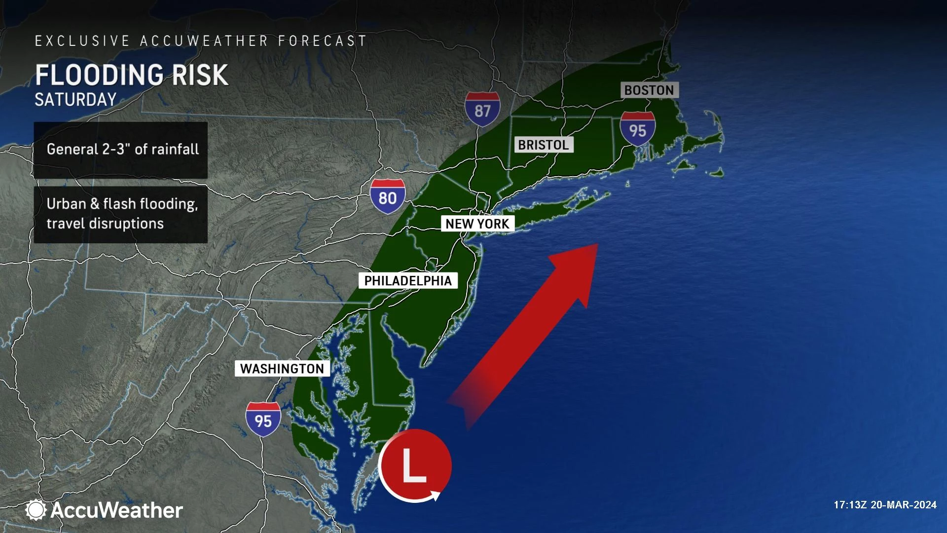
—Wind... Gusts will probably exceed 40 mph for a time, especially along the coast. That magnitude of wind gusts will blow around your garbage can, make driving difficult, and cause sporadic power outages.
—Coastal Flooding... Tidal guidance is showing a foot or two of storm surge from Saturday into Sunday, potentially causing minor to moderate coastal flooding for a couple high tide cycles. Road closures are possible due to water inundation.
—Snow... Unlikely. While accumulating snow is expected across northern New York and New England, it will be too warm — in the 40s and 50s — for any kind of wintry weather in New Jersey. If the storm were about 200 miles farther east, allowing cold air to drag down from the north, it would be a different story.
Sunday
Sunday will be a much nicer, calmer, drier day.
Skies should be mainly clear by daybreak Sunday, although I could see some stubborn clouds hanging along the coast. It will be breezy, with wind gusts to 20 mph, as Saturday's storm system continues to pull away. High temperatures will settle around 50 degrees, just a hair below normal for this time of year.
The Extended Forecast
Monday looks good, by late March standard, with sunshine, a light breeze, and highs in the seasonable lower 50s.
Beyond that, we will have to start watching for active weather again. Next storm system will probably arrive in the Wednesday-Thursday time frame. Another rain-only weather event for NJ.
As our weather stays active, with a few more spurts of rain on the way, I do not see any sustained warmup kicking in until sometime in April.
Final flakes: When does snow season end in NJ?
Gallery Credit: Dan Zarrow
Dan Zarrow is Chief Meteorologist for Townsquare Media New Jersey. Follow him on Facebook for the latest forecast and realtime weather updates.
Get Your NJ 101.5 Merch
Gallery Credit: Nicole Todd
More From 94.5 PST

