NJ weather: Cooler temperatures for most, noisy thunderstorms possible
The Bottom Line
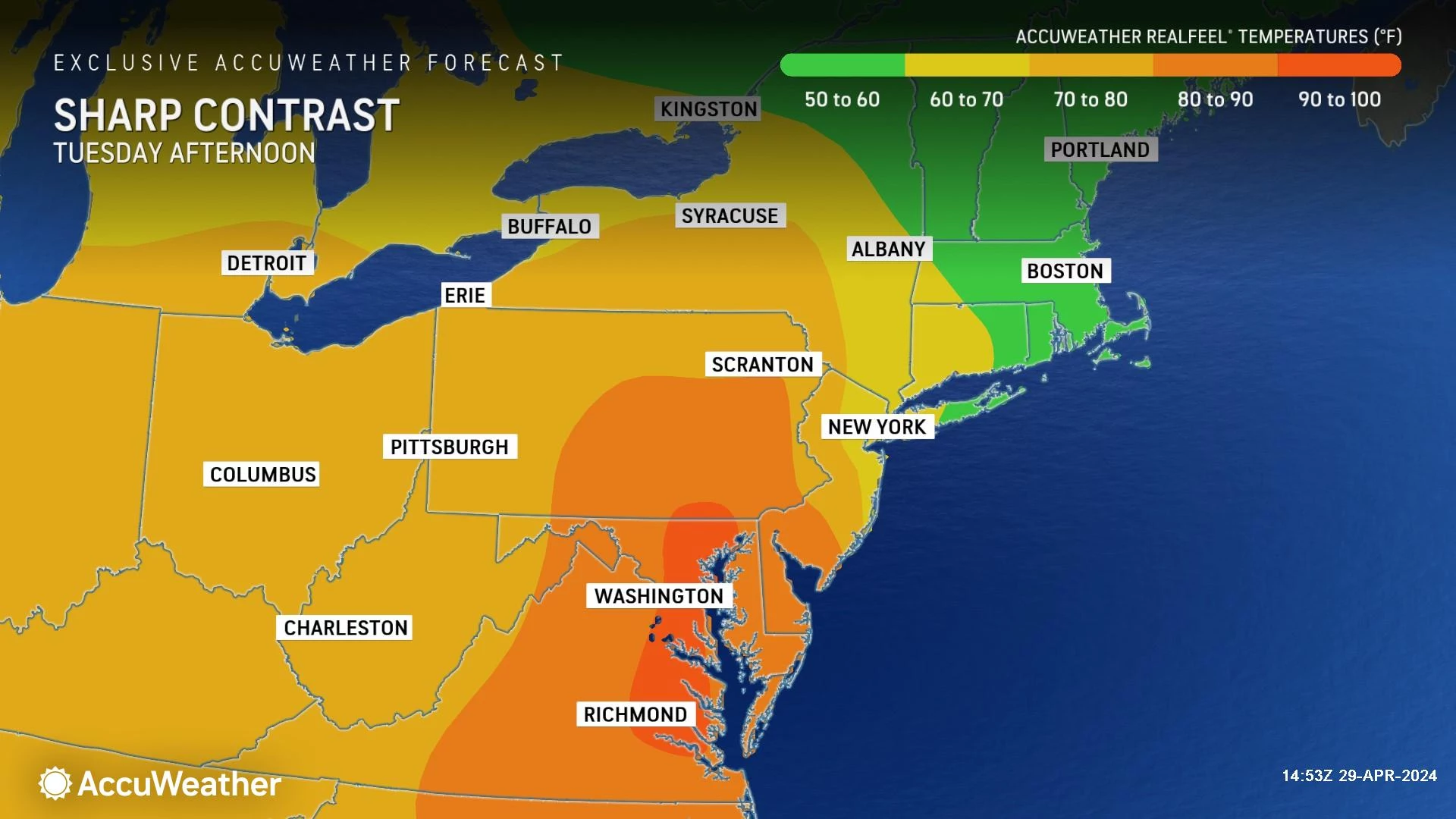
Change is in the air. And you may need a change in your wardrobe Tuesday.
As expected, Monday was a very warm, summerlike day. In fact, it was the first 90-degree day of the year in southwestern New Jersey, in parts of Mercer, Burlington, Camden, Gloucester, and Salem counties. The weather station at Trenton Mercer Regional Airport in Ewing tied the record high for the date, 88 degrees, last set in 1974.
But now, a backdoor cold front will park right on top of New Jersey. That will lead to a very different weather day ... for most of New Jersey. To the north and east, temperatures will only reach the 60s Tuesday afternoon. To the southwest, it's back to the 80s.
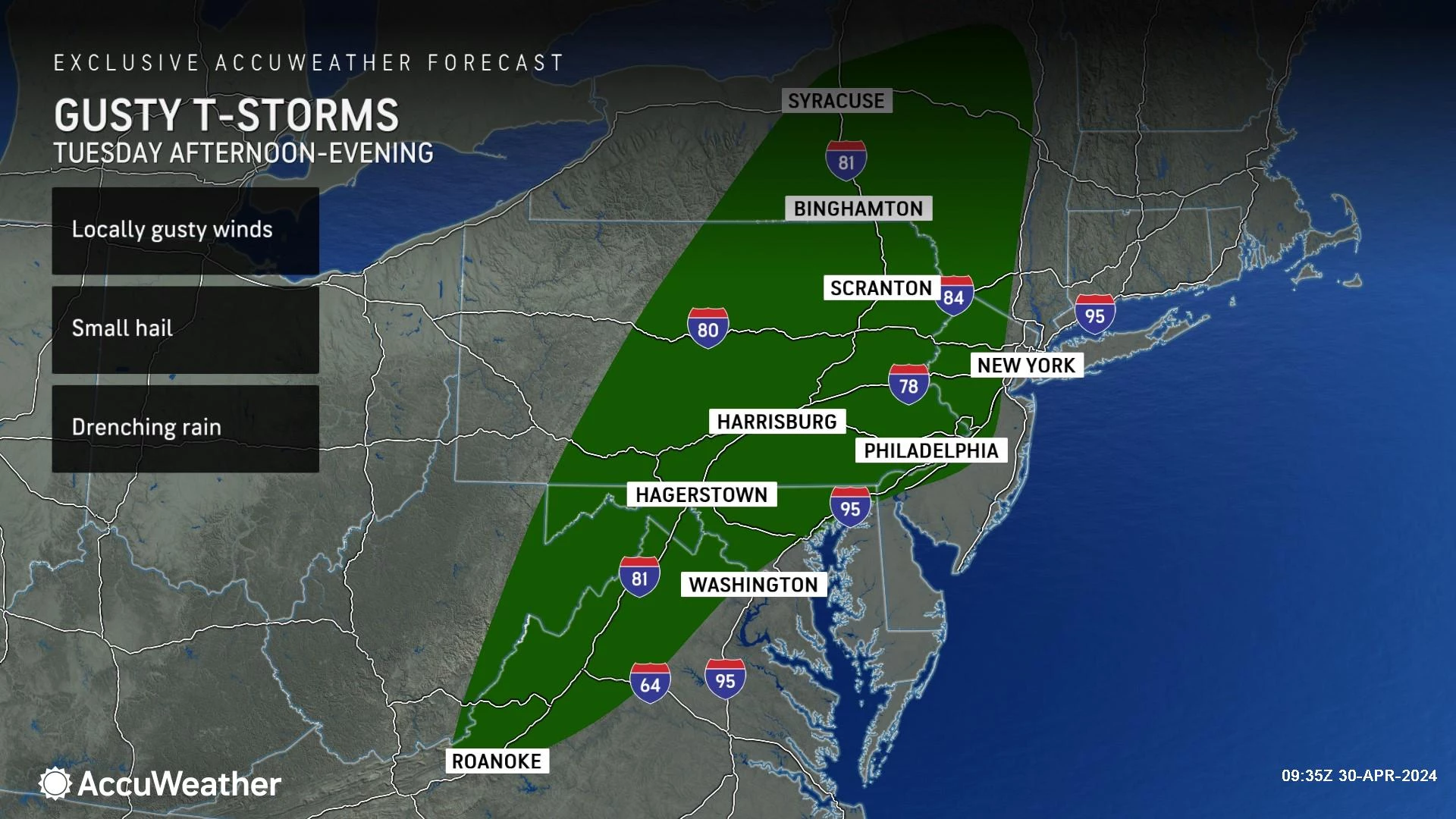
In addition to the wacky temperatures, a round of spotty showers and thunderstorms is looking likely for Tuesday evening. Some of those storm cells could get a bit noisy, with pockets of heavy rain and a gusty wind threat.
We will begin May with a return to pleasant, bright, warm weather. Our next widespread rain chance arrives next weekend.

Tuesday
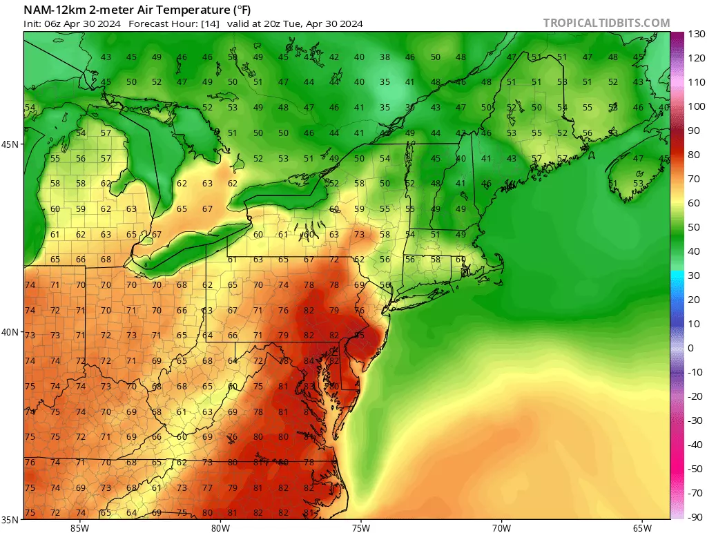
So the big question of the day: Where will the dividing line be between "warm" 80s and "seasonable" 60s? Good question. This is a very challenging forecast.
Southwestern New Jersey will likely see another "shorts weather" day, potentially reaching the lower-mid 80s. That is Burlington, Camden, Gloucester, Salem, and possibly inland Cumberland counties. Almost exactly matching the geography of where the thermometer hit 90+ degrees on Monday.
On the flip side, the northern and eastern edges of the state will certainly be under the influence of cooler, marine-influenced air. Highs may only reach the lower-mid 60s.
Towns along the I-195 and Garden State Parkway corridors in central and southern New Jersey could honestly end up on either side of the line. Including Trenton, Jackson, Toms River, and Egg Harbor Township. My best advice: Plan for middle-ground 70s, and be as flexible as possible in case temperatures trend warmer or cooler than expected.
Otherwise, we are starting out in the 50s with some light fog. Expect a bright sky early on Tuesday. Then clouds fill in through the afternoon. Winds will stay light.
Starting around 4 p.m., we will have to watch for spot showers and thunderstorms to develop. Given the relatively warm and humid atmosphere, those storms could become strong to severe.
The best forcing for thunderstorm growth will be over the Poconos of northeastern Pennsylvania — but those storm cells could easily drift over the Delaware River into New Jersey.
The threat for strong storms is a narrow one, ending around sunset. Additional spotty showers and patchy fog are possible overnight. Low temperatures will once again dip into the 50s across the state.
Wednesday
Model guidance suggests a few showers may linger through about mid-morning — let's say 10 a.m. at the latest. And then, Wednesday should turn into a nice day.
We will see increasing sunshine through Wednesday afternoon. Most high temperatures should end up around 70 to 75 degrees, although the coast will be quite a bit cooler.
Thursday
Thursday looks phenomenal. Partly sunny skies. Completely dry weather. A nice southerly breeze. And high temperatures around 75 to 80 degrees.
Friday
Friday's forecast is not looking as good as it had been. The return of an on-shore breeze and clouds will probably push high temps downward to the upper 60s or so. The current forecast stays dry, although showers may come into play Friday evening.
The Weekend & Beyond
I am not liking what I am seeing for the first weekend of May. Not because we are expecting anything severe or dangerous. But because it could turn rather miserable, as a storm system slowly passes south of New Jersey. That would yield rain, clouds, and unseasonably cool temperatures.
At this moment, Saturday looks to be the better day. We have a shot at dry weather, although skies look pretty gray. High temperatures are forecast to only reach the lower 60s, slightly below seasonal normals.
Sunday is not looking good, unfortunately. Periods of rain, heavy at times, especially to the south, could total over an inch. High temperatures may only reach the 50s.
As soon as that storm system clears the coast, temperatures should shoot up again early next week. Back to the 70s and 80s.
Worst 30 public schools in New Jersey
Gallery Credit: Rick Rickman
Dan Zarrow is Chief Meteorologist for Townsquare Media New Jersey. Follow him on Facebook for the latest forecast and realtime weather updates.
NJ Street Fairs are back! See the latest 2024 schedule
Gallery Credit: Mike Brant
More From 94.5 PST