
Extreme cold and weekend snow for NJ: What we know, what we don’t
UPDATE... This article is outdated...
For the latest winter storm forecast information, please refer to my newest weather blog post.
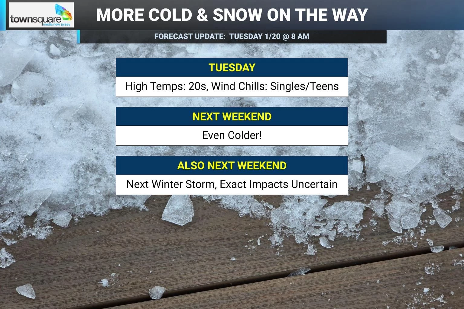
As you may have noticed, it's cold. Temperatures are mainly in the single digits and teens to start Tuesday morning, with a biting wind chill in the single digits. That combination of cold and wind makes this weather potentially dangerous after prolonged exposure due to frostbite and/or hypothermia. Despite sunny skies, high temperatures on Tuesday will only reach the 20s — frozen all day. The wind chill will go no higher than the teens. Tuesday night will be just as cold, although not as breezy, dropping into the teens once again. And then we will temporarily warm up a bit, to the 30s on Wednesday and 40s on Thursday. Even colder air arrives next weekend, along with our next chance of snow.
Tuesday NJ weather: Very cold and breezy, but sunny
One word. Brrr
This flavor of cold weather, where temperatures do not rise above the freezing mark all day is typical in Bangor, Maine perhaps. It does happen here in New Jersey a couple times each winter season. But that does not make it "normal" winter weather. And it does not take away from the fact that extreme cold is serious business — you have to bundle up in your heaviest winter gear. And this weather will cause lots of other struggles from infrastructure to your furnace to your car to the power grid to water mains to firefighting efforts. I really feel for anyone who has to work outside in these conditions!
Temperatures on this Tuesday morning range from single digits in the northwest hills (positive and negative) to mainly teens around the state. I see a few 20s from Atlantic City to Cape May. Factor in the stiff breeze, and wind chills for just about every corner of the state are in the single digits.
High temperatures Tuesday afternoon will only reach about 20 to 25 degrees. The wind chill will go no higher than the teens. At least it will be sunny and dry. In fact, the air will be very dry Tuesday — be sure to moisturize your skin and lips, and stay nice and hydrated.
Tuesday night will be a few degrees colder than the previous night. But hopefully, the wind will be lighter. Expect lows in the teens, with some single digit temps. Wind chills will once again easily dip into the singles.
Wednesday NJ weather: Better
Once we get past the frigidity of Wednesday morning, there will be improvements. Wednesday will be the start of a welcome warmup and thaw ... which will last all of two days.
Morning sun will give way to a few clouds in the afternoon. A lighter breeze will blow out of the southwest throughout the day — it will be noticeable, but not enough to call it a truly "blustery" day.
High temperatures Wednesday are forecast to push back into the mid 30s. Similar to Monday. But still firmly below seasonal normals for late January.
All forecast models show some fizzling snow showers passing over New Jersey Wednesday evening. I would not rule out a few snowflakes. Maybe even a dusting on the ground somewhere. But nothing more than that.
Thursday NJ weather: Warmest of the week
Finally, one mild day! Don't get used to it — this may be our last semblance of warmth for the month of January.
Highs on Thursday will push into the mid 40s, allowing for some solid snow and ice melt. Skies will be partly sunny, with no precipitation in sight. A pleasant January day all around.
Friday & Saturday NJ weather: Turning colder
On Friday, our weather will start to flip in the other direction. It will turn cloudier. It will turn windier too, with gusts potentially climbing to 30+ mph by nightfall. And it will turn colder, with highs back down to the 30s again.
Saturday is just going to be a ridiculously cold day. Morning lows in the single digits, with a wind chill potentially below zero — back in "dangerous cold" territory. Afternoon highs only in the teens for most of New Jersey. The breeze should die down as Saturday goes on, but sunshine will be limited.
NJ's next potential winter storm: What we know
The social media hype is swirling. It seems like everybody is talking about our next potential storm system and chance of snow coming up this weekend.
Yes, there is something worth watching here. But weather forecasting is a game of chaos theory — we have to play this out very carefully. With five days to go until prime impacts, even some of my professional meteorological colleagues are stretching the science and the probabilities a bit.
Here is what we know with a reasonable degree of certainty so far:
1.) There is a prominent storm system signal diving just south of us. Every forecast model shows at least something wintry affecting New Jersey.
2.) This looks like a South Jersey special with more snow to the south than to the north, based on that storm track.
3.) Prime timing is centered around Sunday
4.) It will definitely be cold enough for an all snow situation.
5.) Snow ratios will be very high. Those cold temperatures will yield a very dry, powdery snow, leading to fast, high accumulations.
NJ's next potential winter storm: What we don't know
This is the stage of the forecast where there are more questions than answers. But I think it is important and useful to define those questions so I (and you) can know what to look for in the coming days.
Here is what we don't know yet:
1.) The big overarching question: Will arctic high pressure — the massive dome of cold air that takes over this weekend — suppress or block the storm's impacts here in New Jersey? At the moment, it looks like the heaviest snow will pass south of New Jersey. But how far south will it be?
2.) The big question everyone wants answered: Snow totals. At present, I would say accumulations range from 0 to 20 inches in New Jersey. That is literally the spread of model guidance right now. Other than that, we have to wait another couple days before we can put actual, realistic, believable, confident, non-baloney numbers on this forecast.
3.) Exact timing. I mentioned Sunday is prime time, although I don't want to get more specific than that. Furthermore, model guidance suggests wintry impacts could begin as early as late Saturday afternoon. And the latest operational Euro model is an interesting outlier, showing the storm system rapidly redeveloping and deepening off the coast and lingering through Monday and part of Tuesday too.
4.) Coastal impacts. If that Euro model solution plays out, there could be a storm surge, tidal flooding, and/or erosion component to this storm too. Tide and flooding guidance only runs 72 hours in advance, so we're still days away from peeking at that data.
For now, we wait and watch. Don't expect any specificity in this weekend's forecast until late Wednesday or Thursday at the earliest. And even then, because this storm will be so track specific, there will be changes and evolutions to make right until the last minute.
By the way, behind the storm, it might get even colder early next week. If this keeps up much longer, this winter has a real chance of being truly memorable or even historic!
Dan Zarrow's Top 10 Weather and Climate Stories of 2025
Gallery Credit: Dan Zarrow
Dan Zarrow is Chief Meteorologist for Townsquare Media New Jersey. Follow him on Facebook for the latest forecast and realtime weather updates.
Let it snow: 12 things to know about winter forecasting in NJ
Gallery Credit: Dan Zarrow
More From 94.5 PST


