6 things to know about NJ’s tiny taste of winter, Monday-Tuesday (and beyond)
UPDATE... This article is outdated...
For the latest winter storm forecast information, please refer to my newest weather blog post.
UPDATE as of 4:26 p.m. Monday...
The National Weather Service has issued a series of Winter Weather Advisories for western and northern New Jersey, in effect for varying time periods from Monday evening through Wednesday morning.
There are no big changes to the accumulation or timing forecast.
For more on the advisory, please check out my latest weather blog update here:
ORIGINAL POST from 6:23 a.m. Monday...
The storm system arriving Monday night into Tuesday still looks like ’no big deal’ for New Jersey. It’s really going to struggle to produce much, given very dry air and dubious temperatures. There are no warnings or advisories posted for the state at this time, which I think is very telling.
Having said that, any snowfall will stick to the cold ground quickly and some travel issues are possible. And then we’re watching two more winter storms in the next week. It’s definitely winter!
1.) Monday Daytime
Not a flake or drop to be found. It will be cold, but not as windy or blustery as the weekend. As skies become mostly cloudy, highs will get stuck in the (near-normal) mid to upper 30s.
2.) Monday Night
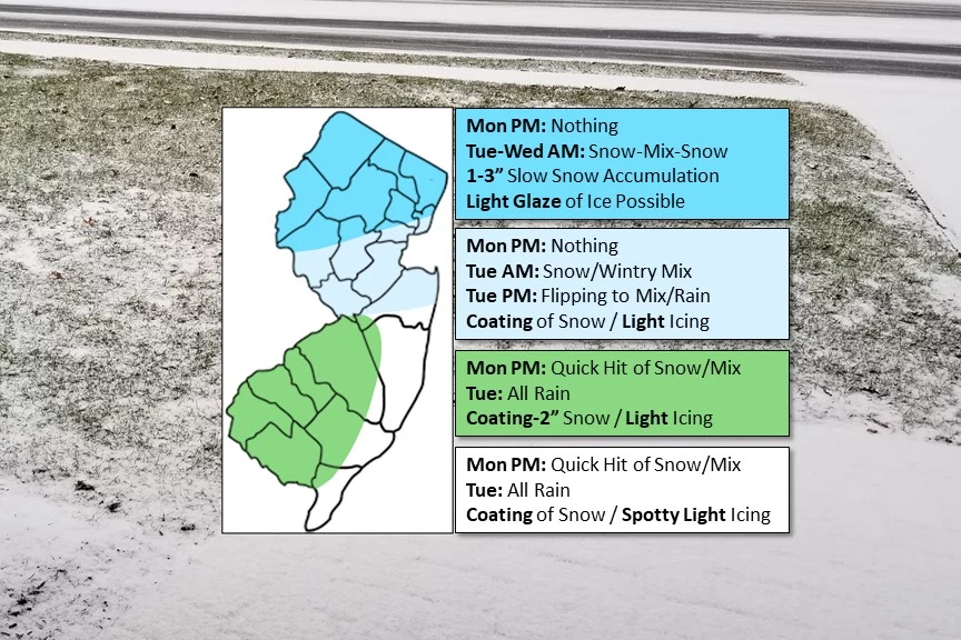
The first phase of our storm system will push precipitation into southwestern New Jersey sometime between 7 p.m. and Midnight. I believe temperatures will allow for this initial band to take the form of snow or wintry mix, rather than straight rain. But the numbers are close.
Overnight, I do not expect any bands of precipitation to reach north of Interstate 195. (And even that might be a stretch.). I have included the chance of a coating to 2 inches of accumulation along the Interstate 295 corridor in SW NJ, just in case we get a burst of moderate snow.
3.) Tuesday Daytime
After daybreak Tuesday, the northern half of the state will start to see some snow and icy mix (sleet and freezing rain), potentially impacting the later part of the AM commute.
Meanwhile, as temperatures slowly rise Tuesday morning, South Jersey will transition to all rain. By lunchtime the rain-snow line will probably reach the Interstate 78 corridor (if not farther north).
My biggest concern here is that any combination of snow, sleet, and (especially) freezing rain would cause some light icing on untreated surfaces, especially early Tuesday morning. As we discuss so often, it does not take much ice for a very slippery glaze to form.
4.) Tuesday Night
Additional light snow in far northern New Jersey could allow snow to continue slowly accumulating through daybreak Wednesday morning. That is why I continue to promote the possibility of 1 to 3 inch snow totals for the tippity-top of the state.
5.) Another Storm Thursday?
After a quiet and fairly pleasant day Wednesday, there’s another storm system looming to the south on Thursday. At the moment, some forecast models depict a miss. And some show the very edge of the storm swiping past South Jersey and the Jersey Shore (with a brief pop of snow Thursday morning).
There’s still time for this system to wiggle either north (closer) or south (away). We’re obviously going to continue watching this one very very closely, with better resolution in the next 24 hours.
Even if we don’t see a flake of snow, that powerful southern storm system looks to bring back the bluster. Thursday and Friday look windy and very cold.
6.) Another Storm Sunday-Monday?
Our active weather pattern continues through early next week, with long-range models picking up on a potentially impactful storm system around the Sunday to Monday time frame. The Euro model in particular shows a big hit of snow for part of New Jersey.
Of course, it is way too early to dive into details. We’ll have a better view of the forecast by the end of the workweek.
Unless something changes dramatically, this will be my last weather blog update before our tiny taste of winter arrives. Stay warm, stay smart, and stay safe out there.
Dan Zarrow is Chief Meteorologist for Townsquare Media New Jersey. Follow him on Facebook or Twitter for the latest forecast and realtime weather updates.
More From 94.5 PST