
Welcome to January – 3 snow chances for NJ in the next 10 days
UPDATE... This article is outdated...
For the latest storm forecast information, please refer to my newest weather blog post.
The Bottom Line
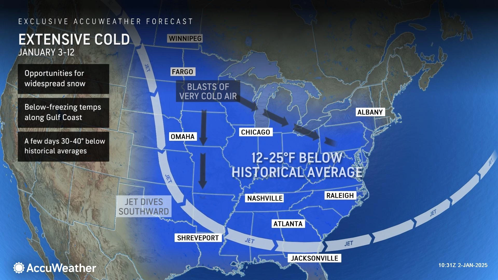
Happy New Year! So far this winter season, we have had five 2+ inch snow events in New Jersey. Not too shabby. But the vast majority of those snowflakes fell in North Jersey — most of the state is firmly holding at below-normal season-to-date snowfall.
Of course, that can change in an instant. Because it is January now — NJ's average coldest and second snowiest month of the year.
And what do you know, we have a cold and active weather pattern setting up over the next week or two. That translates to below-normal temperatures, with highs mainly in the 30s. In addition, we are tracking several potential winter storms, three of which could bring accumulating snow to New Jersey in the next ten days. Friday, Monday, and late next week
The rest of this article will focus largely on those snowy details. But first, an important reminder. Because storm systems this time of year can be so impactful and because they are volatile due to changes in storm track or temperature, I have to play out these forecasts very slowly and carefully. I am not going to hype up a storm or push out big snow totals unless (until) I am confident that is how the storm will play out. My meteorological mission is to be as honest, as accurate, and as precise as possible — and oftentimes that requires patience.
A Resounding Theme: Cold Wind
The first ingredient for any snowy situation is a deep pool of cold air. And we've got one now arriving in New Jersey.
Thursday morning is not awful. Temperatures are in the 30s. But the biting wind, occasionally gusting above 20 mph, adds a chilly bite to the air. Plus, despite sunshine, high temperatures on Thursday will only reach about 40 degrees.
Fair warning: Thursday will be the warmest day of the next week or two.
Thursday night will dip into the upper 20s, with lighter winds at least. And then as Friday turns mostly cloudy, highs will only reach the upper 30s.
Temperatures take another step downward for the first weekend of 2025, in the wake of Friday's mini storm system. Both Saturday and Sunday high temperatures will only hit lower to mid 30s.
And that is about where thermometers will stay next week. Deep in the 20s overnight. Barely into the 30s and barely above freezing during the day.
Do not expect any substantial warmup through at least the midpoint of January. 'Tis the season for bundling up.
Potential Winter Storm #1: Late Friday
Just to be clear: This is a compact (tiny) storm system, which will produce relatively light snow over a short duration of time. In other words, very much a minor winter storm.
However, there could still be some impacts during Friday evening's commute. So it is absolutely worth talking about and knowing about.
This storm system will brush past southern New Jersey late-day Friday. That is late afternoon to evening. To put a finer point on it, precipitation should be limited to about 3 p.m. to 9 p.m.
And it is just a burst of snow across the southern half of the state (or less). Along the coast, temperatures may be a little warmer, and therefore we could see more of a rain-snow mix.
Accumulations will be light. But I still think an inch or two is a solid possibility somewhere in South Jersey. And there is a chance for a brief round of heavy snow. (At least one model shows the possibility of a pocket of 4+ inches.)
For most of the state, north of Burlington and Ocean counties, Friday will only bring increased cloud cover and possibly some flurries. No accumulations or travel impacts to worry about.
Potential Winter Storm #2: Early Next Week
Another storm system sliding west-to-east across the country on Monday looks a bit more impactful for New Jersey.
But with 96 hours (4 days) to go, there is still quite a bit of uncertainty regarding the storm track. And therefore, snowfall totals and the overall impacts are still very much up in the air.
Even forecast confidence surrounding the storm timeline is shaking. I want to call it a "Monday daytime" event. But the Euro model in particular has shifted earlier to a "late Sunday night to Monday morning" time frame. At least that gives you some idea of when roads may become icy, slushy, and/or sloppy.
One thing is for sure: I have high confidence it will be cold enough for an "all snow" event. No wintry mix or rain to worry about here.
As for potential snow accumulations, there are four storm track scenarios in play. Two of these (#2 and #3) are far more likely than the others. Over the next day or two, we will look to refine and narrow down these scenarios, as the forecast gets more confident and more specific.
Scenario #1: Total Miss
—Chance of Playing Out: 15%
—Impacts: If this dome of cold air is too strong, the storm could steer well south of New Jersey, leading to zero precipitation.
—Accumulations: Not a flake
Scenario #2: Southern Scrape
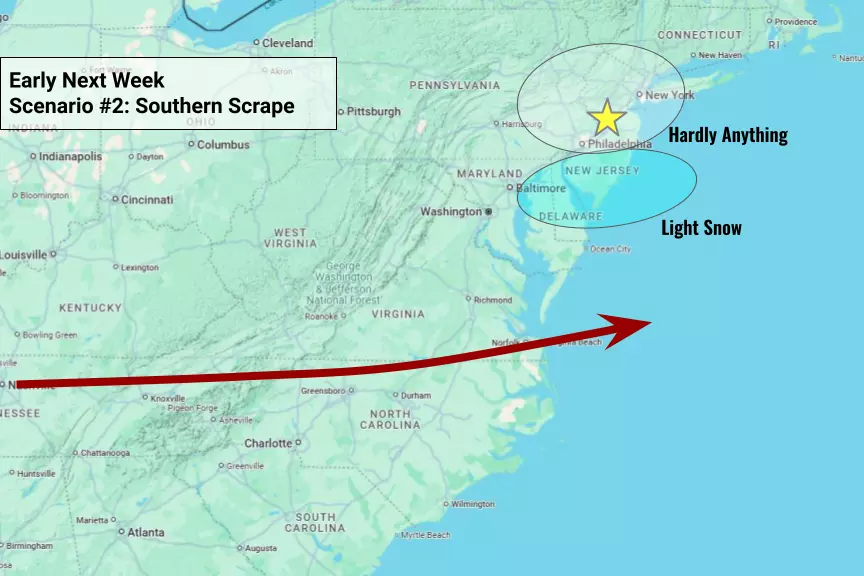
—Chance of Playing Out: 45%
—Impacts: The current favored outcome among forecast models, the storm would come close enough to produce accumulating snow over New Jersey, but the heaviest totals would remain to the south. A classic "South Jersey special" snow storm.
—Accumulations: About 1-3" for the northern half of the state, and 3-6" to the south.
Scenario #3: Snow Sweet Spot
—Chance of Playing Out: 35%
—Impacts: There is a "perfect storm" track, putting southern New Jersey right in the bullseye of heavy snow. Even the northern half of the state could be breaking out the snow plows.
—Accumulations: About 3-6" north, 6-10" south. (I have seen guidance go as high as 14", but that was several days ago.)
Scenario #4: Messy Mix
—Chance of Playing Out: 5%
—Impacts: The most complicated outcome of all, if low pressure were to track directly over NJ, warmer air would force a mainly rain event south of the center. This is also the most unlikely solution, as cold air and high pressure to the north should keep the storm system south of NJ.
Potential Winter Storm #3: Late Next Week
In the wintertime, we are always scanning the horizon for potential trouble. That horizon is realistically about 10 days, a week and a half. There is one more potential storm system that has popped up sporadically in model guidance — a coastal storm (nor'easter) around late next week. Let's call it Friday.
This is a highly uncertain forecast. (Have you ever seen an 8-day weather forecast that was exactly right?) At the moment, all forecast models show a "miss" for New Jersey. However, especially given our current sustained cold air mass, I think it is still worth watching to see if anything does develop.
We would not get serious about this storm until late Monday or early Tuesday. (I also like to take the weather forecast one storm at a time.) If this potential nor'easter becomes a "thing," I promise you will be among the first to know.
Let it snow: 12 things to know about winter forecasting in NJ
Gallery Credit: Dan Zarrow
Dan Zarrow is Chief Meteorologist for Townsquare Media New Jersey. Follow him on Facebook for the latest forecast and realtime weather updates.
Dan Zarrow's Top 10 Weather and Climate Stories of 2024
Gallery Credit: Dan Zarrow
More From 94.5 PST

