Tropical Storm Watch issued for NJ – Isaias 24 to 48 hours away
This article is outdated...
It was published Sunday evening. Since then, watches have been upgraded to warnings. And the forecast for Tropical Storm Isaias continues to evolve and become more refined.
Please check the newest weather blog posting here for the latest storm information:
ORIGINAL POST from 5:13 p.m. Sunday...
As of 5 p.m. Sunday, most of New Jersey, including the entire Jersey Shore, is under a newly issued Tropical Storm Watch. Watches and warnings now extend from Florida all the way to the eastern tip of Long Island.
Tropical Storm Isaias is currently centered 65 miles southeast of Cape Canaveral, Florida — or about 820 miles southwest of Cape May, N.J. It shows maximum sustained winds of 70 mph, and is crawling to the NNW at 9 mph.
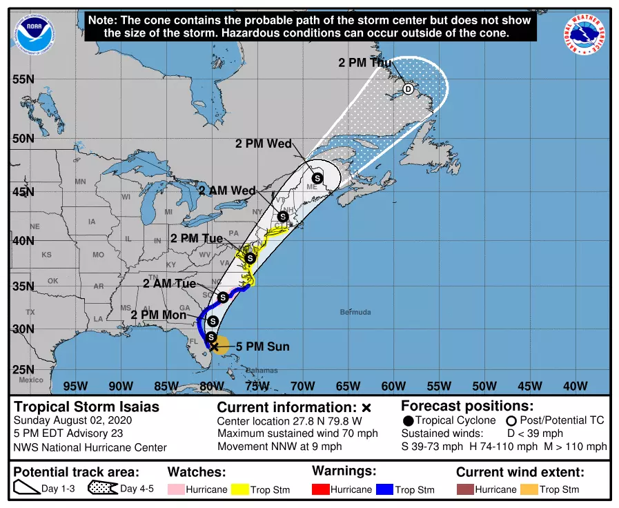
Isaias is expected to make landfall north of Myrtle Beach, South Carolina as a tropical storm on Monday. It will then parallel the Interstate 95 corridor all the way up the coast.
Isaias's impacts are expected to arrive in New Jersey between late Monday night and early Wednesday morning. In other words, Tuesday will be our tropical storm day.

What is a Watch?
Only Sussex and Warren counties in NW NJ fall outside of the watch area.
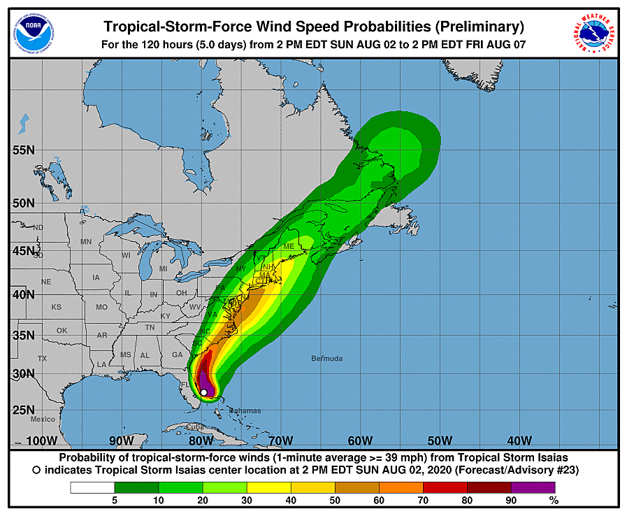
A Tropical Storm Watch is a formal heads-up to possible tropical storm force conditions within 48 hours. That specifically refers to sustained winds of at least 39 mph, which may be accompanied by flooding rain, coastal flooding, and rough surf.
Tropical advisories work a little differently than other weather warnings. They have no expiration time. And are primarily issued for coastal areas — but please keep in mind everyone in New Jersey will feel Isaias's touch here.
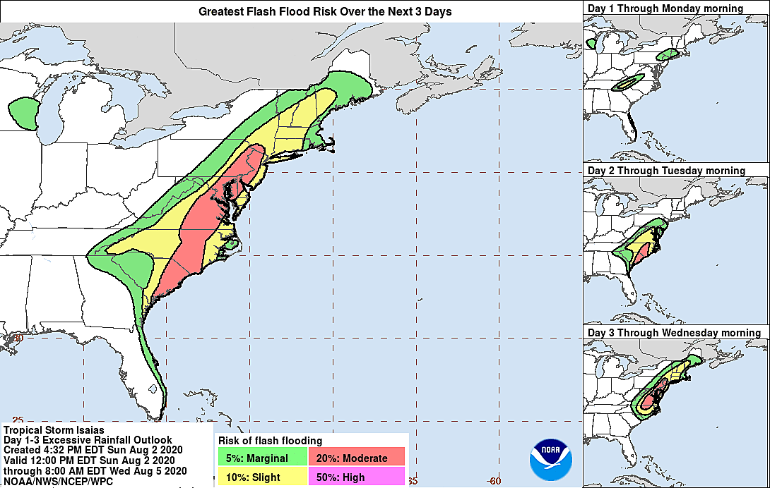
In addition, a Flash Flood Watch has been issued for all 21 counties in New Jersey from Monday evening through Tuesday evening.

A watch does not mean such hazardous weather will occur — only that it is a good possibility.
If the storm stays on target, I suspect tropical storm warnings will be issued sometime Monday. That's a signal that it's time to make final preparations and hunker down for the imminent Isaias.
What to Expect?
There has been little change in expectations and potential impacts since my Sunday morning forecast update.
In summary, inland New Jersey should expect a period of 40+ mph wind gusts, which may blow down branches and cause sporadic power outages. In addition, 3 to 6 inches of rain is likely, with locally higher amounts to 8 inches. That may cause some dramatic flash or river flooding, in addition to making travel conditions (visibility and traction) very challenging.
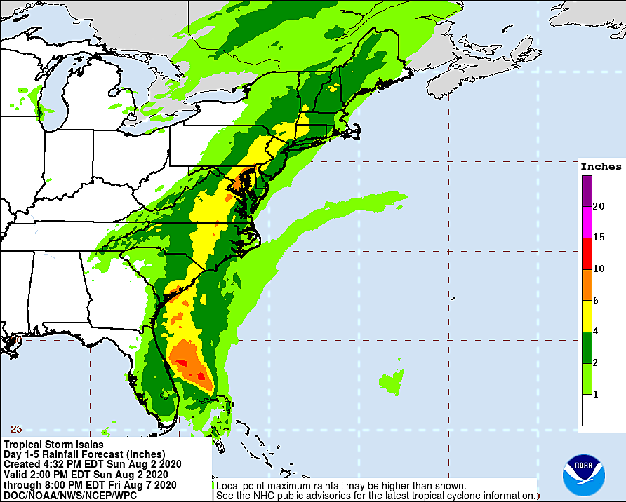
Along the coast, we're probably facing less rain (2+ inches) but fiercer wind (60+ mph gusts). That will be coupled with about 1 foot of storm surge and 10 foot ocean waves, contributing to minor coastal flooding at high tide.
The "worst of the worst" impacts on Tuesday will be nasty, but brief.
What to Do?
Remember Tropical Storm Fay, which swept through New Jersey in early July? Whatever you did to get ready for that storm — or whatever you wish you did — would probably be a good start in preparing for Isaias.
That means securing garbage cans and lawn furniture before the ferocious wind arrives on Tuesday. For those along the Jersey Shore, you may need to tie up your boat extra tight and park your car on higher ground. Carefully consider any outdoor plans or travel (including to/from work), which may be downright dangerous during heavy rain, wind, and/or flooding conditions. Keep your cell phone charged, flashlights ready, and ice cube trays filled, in case you lose power.
I would also recommend having multiple ways to keep up with the latest Isaias forecasts and important emergency information. (Our mobile app is a great place to start!)
Many New Jerseyans won't do a single thing differently as Isaias looms closer on Tuesday. And that's OK — as long as you are aware of the severity of the hazardous weather and have taken the time to think about how it might affect yourself, your family, and your property.
Our weather, news, traffic, digital, and programming teams are now in full "storm mode" until the final raindrops fall and the final wind dies down. Next weather blog update will come out early Monday morning.
Dan Zarrow is Chief Meteorologist for Townsquare Media New Jersey. Follow him on Facebook or Twitter for the latest forecast and realtime weather updates.
More From 94.5 PST