
It’s a South Jersey Snow Day: Monday’s forecast, and what comes next
The Bottom Line
Light snow to the north.
Heavy snow to the south.
Really cold weather coming up.
Monday is a Snow Day for part of New Jersey. Winter storm warnings and advisories are in effect for New Jersey's eight southernmost, with treacherous travel conditions already developing as flakes start to fly.

And what about another potential winter storm at the end of the week?
Let's jump right into the latest forecast.
Monday
I have talked about Monday's "South Jersey Special" winter storm for days and days. For a detailed forecast, let me direct you to my previous weather blog: County by county breakdown of Monday's snow in NJ: What to expect.

Let me give you a few brief bullet points to describe what is happening with the storm and the latest forecast:
—Timeline. Snow arrived in SW NJ right on schedule early Monday morning, and will continue to slowly spread north and east as the morning goes along. The brunt of the storm, the period of the steadiest and most widespread snow, will come from late morning through early afternoon. That will also likely be the time of the most treacherous travel conditions. Snow intensity should start to dial back through the rest of the afternoon hours. But lingering showers will remain possible through Monday evening, especially to the south and east.
—Winter Storm Warning. Now in effect until 1 a.m. for Atlantic, southeastern Burlington, Camden, Cape May, Cumberland, Gloucester, and Salem counties. A less-urgent, less-severe Winter Weather Advisory covers northwestern Burlington and all of Ocean counties for the same time period.
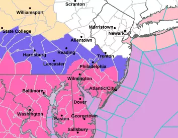
—Forecast Confidence. This has been an unusually difficult storm to nail down, given a wavering storm track and conflicting factors pointing to higher and lower snowfall totals. Ultimately, I published a final forecast ranging from exactly zero inches in North Jersey to upwards of nine inches of snow accumulation in South Jersey. I still like that forecast — which is good, because I do not issue a new snow map after snowflakes have begun. If anything, I think the contours in the middle should be more compressed — my forecast is probably a bit high for the middle segments of the state.

—Heaviest Snow. I believe New Jersey's top snowfall total on Monday will be in Cape May County. The southern edge of the state, including Cape May, Cumberland, and Salem counties are forecast to pick up 6 to 9 inches of accumulation. The rest of South Jersey will probably see about 3 to 6 inches total. It is the first accumulating snowfall there since last February.
—The Battleground. The dividing line between "light snowfall" and "heavy snowfall" will probably set up somewhere over Burlington and Ocean counties. South of that line, plows will be hard at work. North of that line, snow-lovers will be disappointed.
—North Jersey: Ain't Your Storm. The entire northern half of the state could see snowflakes on Monday, but not many of them will stick. A coating to an inch of accumulation is possible. But don't expect much.
—Just Snow. There is no danger of sleet or freezing rain causing icing. Nor rain mixing with snow to reduce accumulations. This is 100% a snow storm for New Jersey, given subfreezing temperatures both at the surface and a mile over our heads.
—It's Cold. Speaking of cold, high temperatures on Monday will only reach about 30 degrees. Luckily, winds will stay light during the day, so the cold air will not have an extra bite to it.
As lingering snow showers taper off by Midnight Monday night, skies will clear quickly. It is going to turn cold and windy — not a good combination. Thermometers will dip to around 20 degrees, especially in areas with fresh snow cover. And the wind chill (the "feels like" or "apparent" temperature) could drop into the single digits. Bundle up!
Tuesday / Wednesday / Thursday
Cold weather will be the resounding weather theme through the rest of the week.
Tuesday will be mostly sunny. And windy, with gusts to about 35 mph. High temperatures will be stuck below freezing, only around 30 degrees. The wind chill will be no better than the teens.

Tuesday night will again dip to around 20 degrees. Frigid.
Highs on both Wednesday and Thursday will again get stuck near 30. With a brisk wind. Ouch.
Friday
Friday is our next opportunity for above-freezing temperatures. But don't expect real "warmth" — highs will only reach the mid 30s. Lighter winds will be a treat. And we should see plenty of sunshine, until clouds fill-in late-day.
The Extended Forecast
Everybody is already clamoring about the forecast for Saturday. Phone apps went wild this weekend about the potential for three feet of snow coming up. Whoa!
But let's hang on a second, and bring that weather forecast back down to planet Earth.
That prediction is based on one model — the GFS — which has had several consistent runs suggesting a coastal storm (nor'easter) with heavy impacts on New Jersey next weekend.
And that possibility is absolutely on the table. I started talking about it last week.
However, every other model currently shows that storm system to be a "miss" — ultimately flying way south of New Jersey.
So there is zero confidence at this time to say whether New Jersey will see significant snow and/or heavy rain and/or damaging winds and/or coastal flooding at the end of the week.
Let's get past our current winter storm, and then we can focus on the next one. I'm sure I will have a lot more to say in the coming days. If it becomes a "thing" and there is snow in the forecast, do not expect a definitive timeline or snow totals or drawing a snow map until Wednesday at the earliest.
Glossary of NJ winter weather words and phrases
Gallery Credit: Dan Zarrow
Dan Zarrow is Chief Meteorologist for Townsquare Media New Jersey. Follow him on Facebook for the latest forecast and realtime weather updates.
The Blizzard of '96 Revisited: Snow totals for every NJ county
Gallery Credit: Joe Votruba
More From 94.5 PST


