NJ weather: Yes it will snow this weekend, but not everywhere
UPDATE... This article is outdated...
For the latest winter storm forecast information, please refer to my newest weather blog post.
The Bottom Line
Coming off a stretch of 6 days of at-or-above normal temperatures, New Jersey returns to the chilly side for Friday and beyond. In fact, temperatures are going to stay at-or-below normal for the foreseeable future.
All things considered, Friday will be a decent December day. Saturday's forecast will be fairly quiet, with just a couple of hiccups. And then Sunday will turn inclement again, as our next statewide storm system rolls in. For most of New Jersey, it is going to be a period of wet weather. But to the north, snow is likely. And light accumulations could lead to slippery spots through early Monday morning.
Friday
It's a seasonably cold start to your Friday morning, with temperatures in the 20s and 30s. High temperatures will read the mid 40s Friday afternoon — probably just a hair below normal for this time of year.
Lots of sunshine, dry weather, and only an occasional breeze will make Friday a pleasant day otherwise. No weather problems at all.
Friday night will be cold again, with a freeze likely across the state. Low temps will dip into the upper 20s to around 30.
Saturday
A major player in Saturday's weather forecast is an area of low pressure that will park right off the coast.
While Saturday will start with sun, clouds will increase statewide through the afternoon. That will keep high temperatures a few degrees cooler than Friday, around 40 to 45 degrees.
In addition, that ocean storm system could spit some raindrops toward our coastline Saturday afternoon. Very light and spotty. But enough to add a "blah" character to the day.
Tidal guidance also shows a foot of surge potentially sparking a couple rounds of minor coastal flooding at high tide this weekend. That equates to water in "the usual spots" — just something to keep in mind for coastal denizens.
Sunday
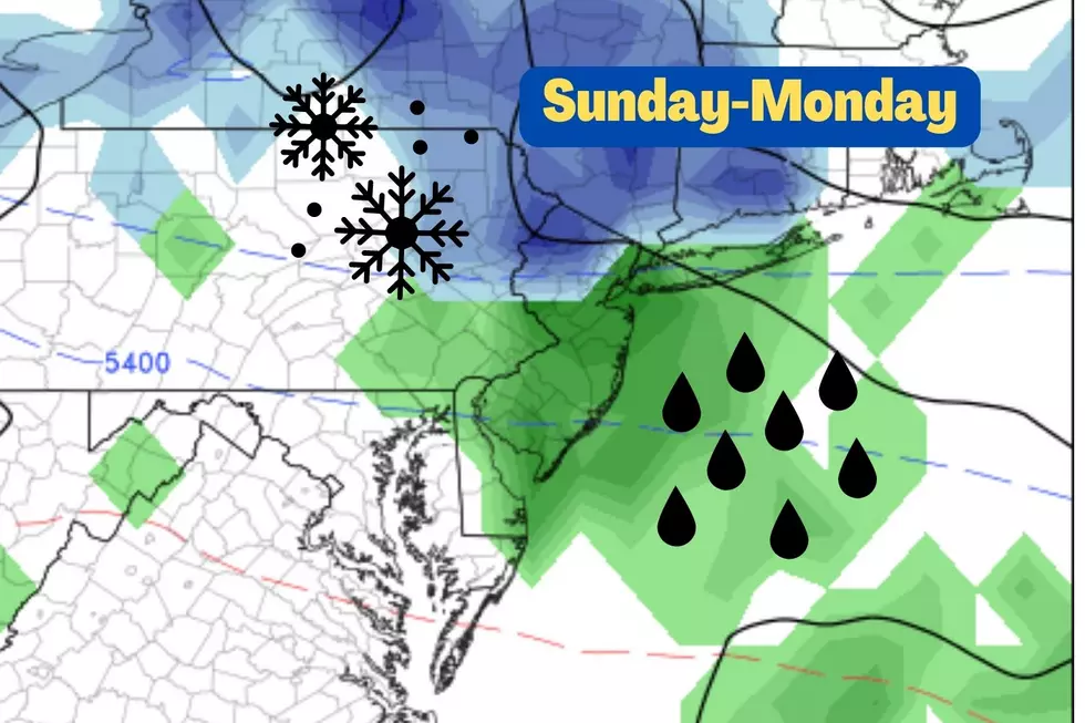
Here's where things get interesting. A storm system arriving from the west will spark a period of precipitation on Sunday. While it does look mainly wet for New Jersey, there will be sufficient cold air this time around for snow to the north.
I really waffled back and forth about whether to draw our first snow map of the year for this system. My general rule is that a storm has to produce 2+ inches of snow over a wide area to give it the full map and infographic treatment. I'm not sure this one qualifies. (I also don't want to overplay such a minor event by taking that leap.)
But let's otherwise give this system the full treatment, so you know what to expect:
—Timeline... Spotty showers may creep in from the west around midday Sunday. Steadier stuff potentially arrives later. (Although that is not a "slam dunk" as rain/snow may remain spotty to scattered throughout the day.) Final showers will not exit the state until sometime Monday morning.
—The Brunt... The most widespread and heaviest precipitation looks to be Sunday afternoon through early evening. Dinnertime. Sunset. Let's say 3 p.m. to 9 p.m.
—Geography... North of Interstate 80 will probably see all snow (or almost all snow/mix). North of the Interstate 78 corridor will probably start as rain, briefly changing over to wintry mix after sunset Sunday. I could see snowflakes making it as far south as Interstate 195, depending on how fast temperatures fall Sunday night and how quickly precipitation comes to an end.
—Accumulations... That "snow zone" of North Jersey could feasibly see an inch or two on the ground by Monday morning. Again, for most of the state, it's just going to be wet (and feel raw).
—Final Thoughts... Not a washout. Not a major wintry storm. It's conversational snow. Just watch for those slippery spots Sunday night and Monday morning. Especially around North Jersey.
Monday
After showers wrap up Monday morning, we return to our trend of quiet but cold weather.
Skies on Monday will stay mostly cloudy, with the potential for late-day clearing. High temperatures will only reach the lower 40s.
The Extended Forecast
The sun comes out, but temperatures do not warm up through the middle of next week. I do not expect thermometers to climb above the lower 40s for Tuesday, Wednesday, and probably Thursday too.
Models do hint at another significant storm system late next week, around the Thursday-Friday time frame. It could be a rightful mess of rain, snow, and wind. Too early for details, but this will definitely be the next thing to watch.
Make it a great weekend — be safe everyone!
Dan Zarrow is Chief Meteorologist for Townsquare Media New Jersey. Follow him on Facebook or Twitter for the latest forecast and realtime weather updates.
A list of NJ malls where you can get photos with Santa for the 2024 holiday season
Gallery Credit: Mike Brant
Let it snow: 12 things to know about winter forecasting in NJ
Gallery Credit: Dan Zarrow
More From 94.5 PST


