Tropical Storm Warning for NJ: 8 things to know about Isaias wind and rain
UPDATE as of 5 p.m. Monday...
No huge changes to report with the Isaias forecast. As of this writing, the storm is eyeing a landfall near Myrtle Beach, South Carolina. And we're already seeing spotty showers in South Jersey, well ahead of the main storm.
A few updates to the information you'll read below:
—The National Hurricane Center and National Weather Service expanded the Tropical Storm Warning to include all 21 counties in New Jersey. That joins the Flash Flood Watch in highlighting Tuesday's big weather hazards from Isaias.
—The "prime time" window for Isaias's peak impacts on New Jersey will be about 10 a.m. to 8 p.m. Tuesday. Within that time frame, any given spot in the state will experience about 5 to 6 hours of nastiness. Note: Oceanfront high tide does NOT occur within that window (9 a.m. and 9 p.m.)
—To the potential wind, rain, surf, and surge issues, we add a slight risk of severe thunderstorms. Specifically, embedded thunderstorms may produce tornadoes. Typical of landfalling tropical storms, which naturally contain a massive amount of energy and spin.
—I really think rainfall totals will be meager along the coast, on the order of an inch or two. But the wind will more than make up for it.
Hopefully you have now battened down the hatches, to whatever extent is necessary for your situation. And you're ready for Isaias's big arrival Tuesday morning.
Next weather blog will be posted early morning.
ORIGINAL POST from 8:07 a.m. Monday...
1.) Where is Isaias now?
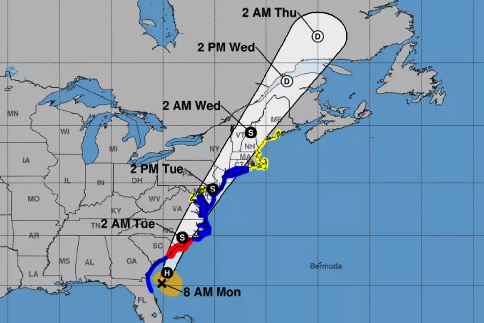
As of 8 a.m. Monday, Tropical Storm Isaias is officially centered 100 miles east-southeast of Jacksonville, Florida. That puts it about 670 miles south-southwest of Cape May, New Jersey. Still a strong tropical storm, maximum sustained winds are holding steady at 70 mph. (75 mph would be a category 1 hurricane.) The entire storm is picking up speed now, cruising to the north at just 13 mph.
Isaias is forecast to make landfall near the South Carolina-North Carolina border sometime Monday night. (That's about the time we'll start to see raindrops here in the Garden State.) As Isaias's center parallels the Atlantic seaboard, it will drag heavy rain and tropical force winds all the way up the coast. Watches and warnings now stretch from Florida to Maine!
2.) What is a Tropical Storm Warning?
For the second time in less than 4 weeks, New Jersey is under a Tropical Storm Warning, with some nasty weather and surf conditions ahead. It means it's time to start taking the storm seriously, and to finish plans and preparations for the storm's arrival.
The Tropical Storm Warning covers the following counties along the eastern and southern edges of the state: Bergen, eastern Passaic, Hudson, Essex, Union, Middlesex, Monmouth, Ocean, southeastern Burlington, Atlantic, Cape May, and Cumberland counties.
Technically "tropical storm force conditions" refer to sustained winds (a 1-minute average) of 39 to 74 mph. And yes, the biggest threat for such gales will be along the coast, in those counties highlighted by the warning. But let's not forget that tropical rainfall will also be a concern — a Flash Flood Watch covers all 21 counties of New Jersey, from Monday evening through Tuesday evening.
3.) When will the storm arrive in NJ?
First raindrops will hold off until Monday evening, spreading from south to north by Midnight. That rain will become steadier around daybreak Tuesday.
The heaviest rain bands and strongest wind gusts are forecast to arrive between Tuesday late morning and Tuesday evening (again, progressing from south to north).
Isaias's center will pass directly over New Jersey Tuesday evening. Shortly after that point, rainfall intensity should decrease and winds should start to calm.
As Isaias continues charging northeast, it will exit New Jersey completely by early Wednesday morning (by daybreak at the latest). Conditions will improve rapidly as the low pulls away.
4.) What's the worst impact expected here in New Jersey?
It depends where you live.
To the right (east) of the center's path — i.e. the Jersey Shore — wind gusts of 70+ mph are possible. Yikes. That's strong enough to bring down trees and cause widespread power outages.
To the left (west) of the center's path — i.e. western New Jersey — rainfall totals may exceed 3 inches. In fact, models show a "fetch" of 5+ inches of rain just west of the Delaware River, which could easily "wobble" in our direction. Flash flooding and river flooding could cause travel difficulty and property damage.
Yes, it's going to rain along the coast too (on the order of an inch or two, at the most). Yes, it's going to be quite windy farther inland too (with 50+ mph gusts). But if we're talking about the worst of the worst from Isaias, your mileage may vary depending on your longitude.
5.) What about the coast?
Any time a tropical system eyes the Jersey Shore, we hold our collective breath regarding storm surge. That's the big wind-driven push of ocean water that can cause massive flooding along coastal areas. (Superstorm Sandy had surge and water rise on the order of 12 feet along the Jersey Shore.)
Luckily, the orientation and fast forward speed of Isaias will limit its coastal flood potential here in New Jersey. Surge models are showing about a foot of water rise along the oceanfront (and perhaps up the Delaware River basin too). That, combined with 10 foot crashing ocean waves and a full moon, is enough to cause minor coastal flooding.
I often call minor category flooding "the usual spots". Those vulnerable places along NJ's tidal waterways that flood every time the water is anomalously high.
The two precarious high tide cycles will be 9 a.m. and 9 p.m. along the Atlantic Ocean. (Water levels peak up to 3 hours later on back bays.) Road closures may be necessary if areas become inundated with water.
In addition, the surf is already getting rough as Isaias churns up the entire Atlantic. Monday will be a nice beach day, but I wouldn't even consider going in the ocean. Our rip current risk is moderate Monday, likely surging to high on Tuesday.
6.) What should I do to prepare?
Possibly nothing, quite honestly. I think the best thing you can do for yourself is to carefully consider your plans on Tuesday. If you can help it, you don't want to be out and about driving around in the middle of a tropical storm. Again, prime impacts will be late morning through evening. So the morning commute will just be wet. The evening commute will be atrocious.
You may always way to secure garbage cans and lawn furniture before the ferocious wind arrives on Tuesday. For those along the Jersey Shore, you may need to tie up your boat extra tight and park your car on higher ground if your street is particularly vulnerable to tidal flooding. Keep your cell phone charged, flashlights ready, and ice cube trays filled, in case you lose power.
The storm is only going to be here for a day and a half, tops. You don't need to make a run on the store for bread and milk. (Unless, of course, you want to make some delicious french toast — yum!
7.) How will Isaias compare to Tropical Storm Fay, from last month?
Many folks have asked if Isaias will be "another Sandy". Or similar to Irene, Floyd, or a strong wintertime nor'easter. And the answer is no, both because each storm has its own "character" and headlines and because Isaias won't be a truly worst-case scenario.
Probably the most helpful comparison is to Tropical Storm Fay, which made landfall near Brigantine, New Jersey just 24 days ago. Fresh in our minds, and similar in overall storm magnitude, at least.
My final Fay forecast, published July 9th, called for the following: "Top rainfall totals in New Jersey will probably exceed 3+ inches. Top wind gusts (along the coast) will probably exceed 40+ mph. Less than a foot of storm surge will cause minor coastal flooding at high tide. A high risk of rip currents is already posted for tomorrow."
In other words, the rain and flooding potential across inland NJ will be slightly greater from Isaias. (Just because of the threat for that 6" rain swath slipping from PA to NJ.) I'm pretty confident that wind gusts will be quite a bit stronger too, especially at the Shore. Storm surge and waves marginally worse, but not worth writing home about.
Whatever you did to prepare for Fay — or whatever you wish you did — I would do it again this time around.
8.) Final thoughts?
What I've pieced together here is the most likely, most reasonable Isaias forecast. It is derived from the consensus among several forecast models, which have successfully converged on similar tracks, timelines, and totals. I would call my confidence "medium".
It's not a slam dunk. The GFS model in particular shows a much faster moving storm, with the bulk of Isaias gone by dinnertime Tuesday. (No complaints here, if that verifies.) Meanwhile, if the storm wobbles just 20 miles in either direction, it could shift the axis of heaviest rain and wind. Tricky.
We hope for the best and plan for the worst. Bottom line: Tuesday is going to be a nasty, potentially dangerous "tropical storm day" across New Jersey. No matter where you live, you are going to feel Isaias's touch.
Dan Zarrow is Chief Meteorologist for Townsquare Media New Jersey. Follow him on Facebook or Twitter for the latest forecast and realtime weather updates.
More From 94.5 PST


