Wednesday NJ weather: Frosty start, cool and breezy finish
The Bottom Line
The growing season has officially ended across most of New Jersey, as frosty and even frozen temperatures reached deep into South Jersey Wednesday morning. As thermometers bottom out, it looks like this will be our coldest morning since early May.
So don't be afraid to bundle up a bit Wednesday morning. And you might need to warm up the car a bit to defrost it.
We'll be stuck under a very cool, very dry air mass for Wednesday and Thursday. Both high and low temperatures will be at least 10 degrees below normal for mid-October.
As a storm system over the Great Lakes shifts to our north, that will open the door to sunshine and a warming trend for Friday and Saturday.
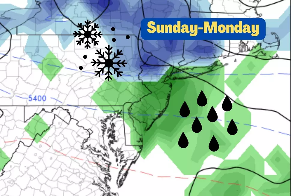
More models are coming on board with a coastal storm system brushing by New Jersey on Sunday. At the very least, that will lead to increased cloud cover and decreased temperatures. And we could see some healthy rain too, on the order of an inch-plus along the Jersey Shore to end the weekend.

Wednesday
To start the day, northwestern New Jersey is in the 20s, and most inland areas are in the 30s. Along the Delaware River, Atlantic Ocean, and Hudson River, it is a little warmer in the 40s.
High temperatures on Wednesday will be limited to the lower to mid 50s. Keep in mind, normal highs are between 64 and 67 degrees right now, so Wednesday's weather will be more typical of mid-November than mid-October.
In addition, a stiff southwesterly breeze will kick up. Gusting perhaps over 20 mph. That's going to keep the cool air moving around, making a jacket even more necessary.
We'll start the day with sunshine. Some clouds will build through the afternoon. But I expect we will stay dry.
Will Wednesday night be as cold as last night? By the numbers, it will be close. Frost is possible again. Of course, the breeze will probably continue (at least on an occasional basis). So we have to talk about the wind chill (or "feels like" or "apparent" temperature). It may dip as low as 30 degrees.
Thursday
About the same. Sunny again. Breezy again. Dry again. And cool again.
Thermometers may improve slightly Thursday afternoon, with high temperatures pushing back into the mid to upper 50s. (Similar to Tuesday, but with the continuing stiff breeze.)
Friday
Our inevitable warming trend really kicks in Friday, with a morning non-frost for most of the state. And high temperatures hopefully improving to the lower 60s Friday afternoon.
We'll see a pleasant mix of sun and clouds to end the workweek.
Saturday
Probably the nicest day in the 5 Day Forecast. Certainly the warmest.
Saturday will be mostly sunny, with high temperatures rising to the upper 60s to around 70. You'll probably need a sweatshirt or jacket early and late. But I will never complain about the potential for 70 degree temperatures in the fall.
Sunday
The forecast turns iffy on Sunday though. For a few runs, the European model has been hinting a coastal storm system would brush past the mid-Atlantic. And now that the GFS model is on-board, it's time to get serious about rain chances.
There are still more questions than answers in the forecast right now:
—Will the storm come close enough to bring rain to both inland and coastal NJ? (Current forecast says yes, it would rain everywhere in the state.)
—How will the storm timeline play out? (Right now, rain looks to start around midday Sunday.)
—Could heavy rain or convection/thunderstorms come into play? (Best chance for inch-plus rainfall would be along the eastern edge of NJ.)
—Will there be any other impacts to worry about, like wind, coastal flooding, beach erosion, or wintry weather? (As of now, the answer is no.)
Coastal storm systems are tricky. Weather impacts are highly track dependent. And they can change suddenly as the storm intensifies, weakens, or changes size/characteristics. For now, just know that we could see rainy weather to end the weekend. We'll drill into finer detail as it gets closer.
The Extended Forecast
If all goes according to plan, that coastal storm system will exit early Monday. And then the sun comes out, and we enjoy a stretch of mild, sunny weather next week. Daily high temperatures could top 70 degrees for Monday, Tuesday, and Wednesday.
Next chance of rain and cooldown wouldn't be until the second half of next week.
Dan Zarrow is Chief Meteorologist for Townsquare Media New Jersey. Follow him on Facebook or Twitter for the latest forecast and realtime weather updates.
11 years later — Sandy makes landfall in New Jersey
25 costliest hurricanes of all time
More From 94.5 PST


