A snowy, rainy, windy night: NJ storm breakdown, county by county
UPDATE as of 5:20 p.m. Sunday...
Snow is spreading north through New Jersey, on schedule and on target. As expected, snow is sticking immediately to all surfaces because it's been so cold.
Be aware that road conditions may go downhill quickly from this initial burst of snow, before the eventual flip to rain later Sunday evening.
UPDATE as of 3:45 p.m. Sunday...
The National Weather Service just pushed out a few last-minute advisory updates:
1.) An extension of the Winter Weather Advisory down the I-295 corridor, now including NW Burlington, Camden, Gloucester, and Salem counties. (This is likely due to colder-than-expected temperatures and watching radar trends.) The initial burst of snow will be brief - the advisory expires at 10pm. But it could cause travel issues.
2.) Middlesex and Monmouth counties have been upgraded to a Coastal Flood Warning. The strong easterly wind pushing water into the Raritan Bay basin is now expected to cause widespread moderate category flooding at high tide Monday morning.
3.) Atlantic and Cape May counties were added to the Coastal Flood Advisory. Up to a foot of surge could cause tidal waterways to exceed (minor) flood stage Monday morning.
I have made the appropriate adjustments to the Advisories and County by County sections below.
UPDATE as of 3:15 p.m. Sunday...
ORIGINAL POST from 10:07 a.m. Sunday...
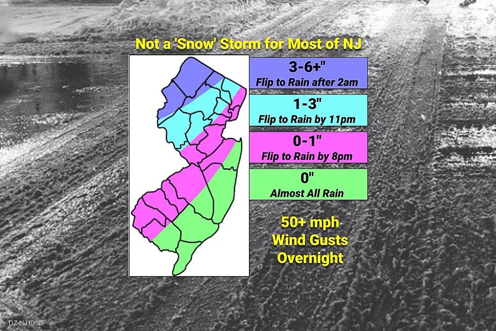
The Bottom Line
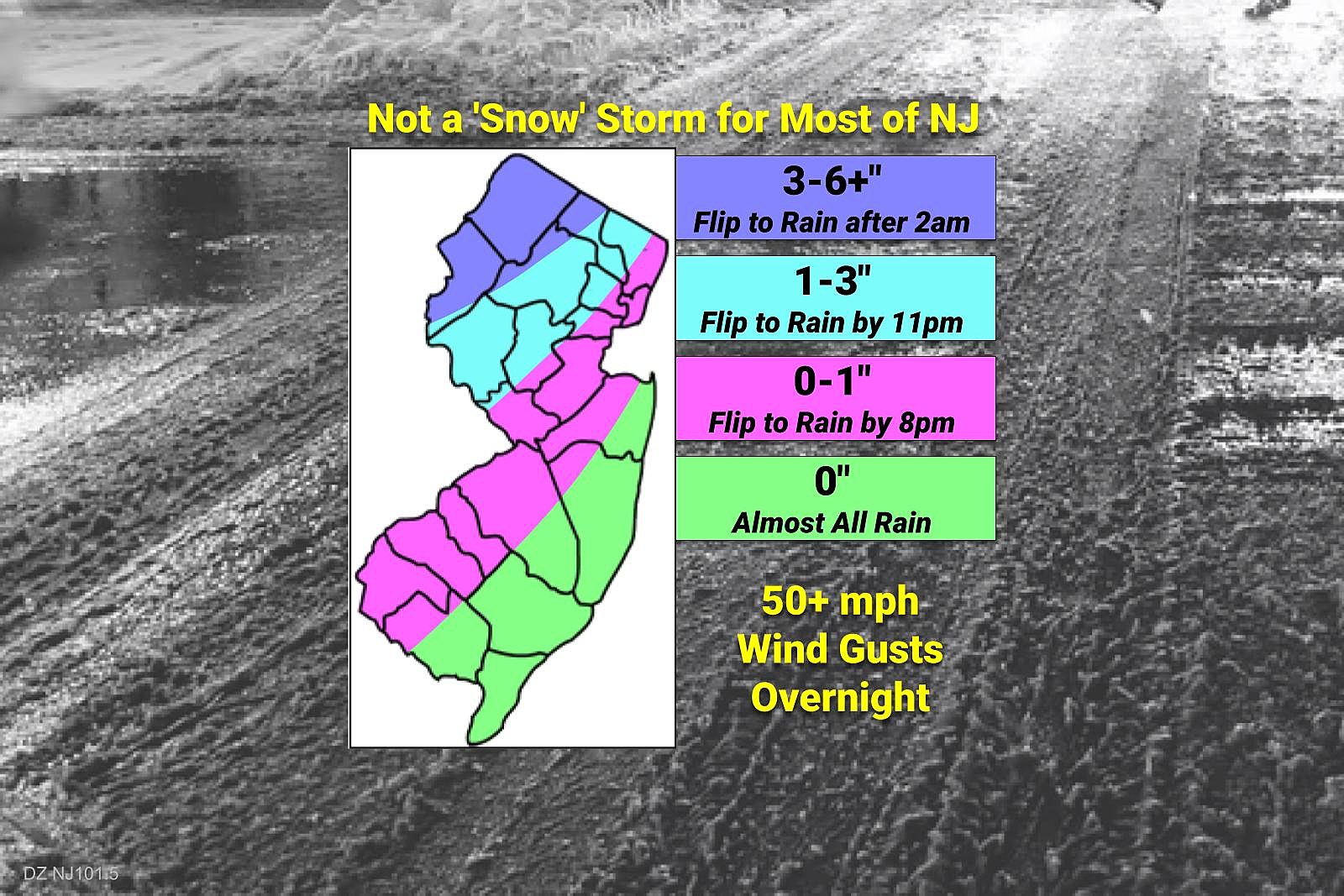
—Weather and road conditions will go downhill starting late Sunday afternoon. Most widespread snowfall will be early Sunday evening. Heaviest precipitation will come late Sunday evening through early Monday morning.
—This will not be a 'snow' storm for most of New Jersey. The biggest snow accumulations from this nor'easter - on the order of 1 to 2 feet - will be over western Pennsylvania and western New York.
—The only corner of the state with wintry issues for Monday morning is north of I-80, west of I-287.
—Highest uncertainty surrounds just how much snow can accumulate, before warmup and rain changeover. Especially true for "the snow zone" around Sussex County.
—The wind is going to be fierce everywhere, but especially along the coast. Expect 40 to 50+ mph gusts overnight, causing sporadic power outages, reduced visibility, and increased nastiness.
Advisories
A Winter Weather Advisory cautions of hazardous travel conditions across all or part of 11 counties in New Jersey: northwestern Burlington, Camden, Gloucester, Hunterdon, Mercer, Morris, western Passaic, Salem, Somerset, Sussex, and Warren.
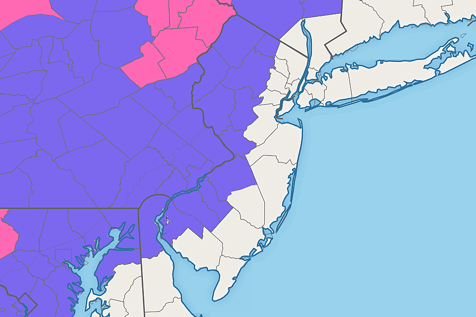
A Wind Advisory pinpoints the area most likely to see 50 mph wind gusts overnight, covering all or part of 6 counties along the NJ coast: Atlantic, southeastern Burlington, Cape May, Middlesex, Monmouth, and Ocean.
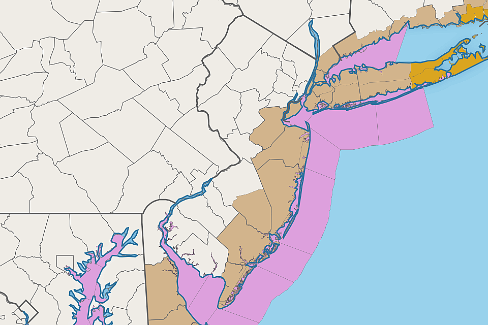
A Coastal Flood Warning has been issued for Middlesex and Monmouth counties, as the strong easterly wind pushes the Raritan Bay and related tidal waterways above moderate flood stage Monday morning.
A Coastal Flood Advisory has been issued for the oceanfront, back bays, and tributaries along the rest of the Jersey Shore. Widespread minor to localized moderate flooding of tidal waterways is possible early Monday morning. This includes coastal portions of Atlantic, Cape May, eastern Essex, Hudson, Ocean, and eastern Union counties.
County-by-County Breakdown
The remainder of this article contains a section for each of New Jersey's 21 counties, listed alphabetically from Atlantic to Warren. I've attempted to pinpoint approximate timing and impact for each segment of New Jersey, so you can plan accordingly to stay safe and warm and dry.
This process is admittedly semi-automated (lots of copy-and-paste-and-edit) and prone to occasional typos and mistakes. I've tried to get as specific as possible with the information presented here, but please understand there is an inherent "margin of error" or "fudge factor" baked into these times and accumulations. If you notice anything really odd, please reach out for clarification via email or social media.
Atlantic County
—Sunday Daytime... Not bad. A very cold morning. Then partly sunny with light winds and dry weather through mid-afternoon. High temperatures in the lower 40s.
—The Arrival... The storm's first band of precipitation should arrive around 5 p.m. Sunday evening as rain.
—The Flip... Almost all rain for the duration. Any wintry mix should turn to plain rain by about 7 p.m. Sunday.
—The Brunt... Heaviest rain bands expected between about 9 p.m. and 3 a.m.
—The End... Rain should largely wrap up and wind should start to calm starting around 4 a.m. Additional snow or rain showers may linger over New Jersey through Monday afternoon.
—Total Snow Accumulation... 0" to a coating, especially in far western Atlantic County. Quickly washed away by rain.
—Total Ice Accumulation... Little to none. Too warm.
—Total Rainfall... 1 to 1.5 inches. Ponding (big puddles) is possible.
—Winter Weather Advisory... None, but watch for slippery spots.
—Wind Advisory... From 6 p.m. Sunday to 3 a.m. Monday, calling for gusts to 50 mph.
—Coastal Flooding WWA... Coastal Flood Advisory from 5 a.m. to 11 a.m. Monday, calling for minor flooding at high tide.
Bergen County
—Sunday Daytime... Not bad. A very cold morning. Then partly sunny with light winds and dry weather through mid-afternoon. High temperatures in the mid 30s.
—The Arrival... The storm's first band of precipitation should arrive around 7 p.m. Sunday evening as snow.
—The Flip... By around 11 p.m. or Midnight, temperatures will warm enough to force snow to transition to plain rain. Ice and slush could lead to additional slippery spots for several more hours.
—The Brunt... Heaviest bands of wintry mix and rain expected between about 11 p.m. and 5 a.m.
—The End... Rain should largely wrap up and wind should start to calm starting around 6 a.m. Additional snow or rain showers may linger over New Jersey through Monday afternoon.
—Total Snow Accumulation... A coating to 1" east. 1" to 3" for the western half of Bergen County. Most, if not all, will be washed away quickly by rain.
—Total Ice Accumulation... A trace of ice, due to sleet and/or freezing rain, is possible if a period of icy mix occurs during the transition from snow to rain.
—Total Rainfall... About an inch. Some ponding (big puddles) may occur.
—Winter Weather Advisory... None, but watch for slippery spots.
—Wind Advisory... None, but wind gusts to 40+ mph are possible.
—Coastal Flooding WWA... N/A
Burlington County
—Sunday Daytime... Not bad. A very cold morning. Then partly sunny with light winds and dry weather through mid-afternoon. High temperatures in the upper 30s.
—The Arrival... The storm's first band of precipitation should arrive around 5 p.m. Sunday evening as wintry mix or snow.
—The Flip... Any snow or wintry mix should change to plain rain by about 8 p.m. Sunday. Slushy or icy conditions may continue for a little while longer.
—The Brunt... Heaviest bands of precipitation will come as rain between about 9 p.m. and 3 a.m.
—The End... Rain should largely wrap up and wind should start to calm starting around 4 a.m. Additional snow or rain showers may linger over New Jersey through Monday afternoon.
—Total Snow Accumulation... To the southeast, little to none. Closer to the Delaware River, a quick inch of snow may accumulate early Sunday evening. Anything on the ground will be washed away by the subsequent heavy rain.
—Total Ice Accumulation... A trace of ice, due to sleet and/or freezing rain, is possible if a period of icy mix occurs during the transition from snow to rain.
—Total Rainfall... About an inch. Some ponding (big puddles) may occur.
—Winter Weather Advisory... In effect from 4 p.m. to 10 p.m., as the initial burst of snow and ice could cause travel issues.
—Wind Advisory... None, but wind gusts to 40+ mph are possible.
—Coastal Flooding WWA... For southeastern (coastal) Burlington, Coastal Flood Advisory from 5 a.m. to 11 a.m., calling for minor flooding at high tide.
Camden County
—Sunday Daytime... Not bad. A very cold morning. Then partly sunny with light winds and dry weather through mid-afternoon. High temperatures in the upper 30s.
—The Arrival... The storm's first band of precipitation should arrive around 5 p.m. Sunday evening as wintry mix or snow.
—The Flip... Any snow or wintry mix should change to plain rain by about 8 p.m. Sunday. Slushy or icy conditions may continue for a little while longer.
—The Brunt... Heaviest bands of precipitation will come as rain between about 8 p.m. and 3 a.m.
—The End... Rain should largely wrap up and wind should start to calm starting around 4 a.m. Additional snow or rain showers may linger over New Jersey through Monday afternoon.
—Total Snow Accumulation... A quick inch of snow may accumulate early Sunday evening. Anything on the ground will be washed away by the subsequent heavy rain.
—Total Ice Accumulation... A trace of ice, due to sleet and/or freezing rain, is possible if a period of icy mix occurs during the transition from snow to rain.
—Total Rainfall... About an inch. Some ponding (big puddles) may occur.
—Winter Weather Advisory... In effect from 4 p.m. to 10 p.m., as the initial burst of snow and ice could cause travel issues.
—Wind Advisory... None, but wind gusts to 40+ mph are possible.
—Coastal Flooding WWA... None.
Cape May County
—Sunday Daytime... Not bad. A very cold morning. Then partly sunny with light winds and dry weather through mid-afternoon. High temperatures in the lower 40s.
—The Arrival... The storm's first band of precipitation should arrive around 4 p.m. Sunday afternoon as rain.
—The Flip... Almost all rain for the duration. Any wintry mix should turn to plain rain by about 7 p.m. Sunday.
—The Brunt... Heaviest rain bands expected between about 8 p.m. and 2 a.m.
—The End... Rain should largely wrap up and wind should start to calm starting around 3 a.m. Additional snow or rain showers may linger over New Jersey through Monday afternoon.
—Total Snow Accumulation... 0". A few snowflakes may fall early on, but no accumulation is expected.
—Total Ice Accumulation... Little to none. Too warm.
—Total Rainfall... 1 to 1.5 inches. Ponding (big puddles) is possible.
—Winter Weather Advisory... None, but watch for slippery spots.
—Wind Advisory... From 6 p.m. Sunday to 3 a.m. Monday, calling for gusts to 50 mph.
—Coastal Flooding WWA... Coastal Flood Advisory from 5 a.m. to 11 a.m. Monday, calling for minor flooding at high tide.
Cumberland County
—Sunday Daytime... Not bad. A very cold morning. Then partly sunny with light winds and dry weather through mid-afternoon. High temperatures in the lower 40s.
—The Arrival... The storm's first band of precipitation should arrive around 4 p.m. Sunday afternoon as wintry mix or snow.
—The Flip... Almost all rain for the duration. Any wintry mix should turn to plain rain by about 7 p.m. Sunday.
—The Brunt... Heaviest rain bands expected between about 8 p.m. and 2 a.m.
—The End... Rain should largely wrap up and wind should start to calm starting around 3 a.m. Additional snow or rain showers may linger over New Jersey through Monday afternoon.
—Total Snow Accumulation... 0" to 1". A brief period of snow may happen at onset. But anything on the ground will be washed away by the subsequent heavy rain.
—Total Ice Accumulation... Little to none for most. A trace is possible to the west, in the middle of the transition from snow to rain.
—Total Rainfall... 1 to 1.5 inches. Ponding (big puddles) is possible.
—Winter Weather Advisory... None, but watch for slippery spots.
—Wind Advisory... None, but wind gusts to 40+ mph are possible.
—Coastal Flooding WWA... None.
Essex County
—Sunday Daytime... Not bad. A very cold morning. Then partly sunny with light winds and dry weather through mid-afternoon. High temperatures in the upper 30s.
—The Arrival... The storm's first band of precipitation should arrive around 6 p.m. Sunday evening as snow.
—The Flip... By 10 or 11 p.m., temperatures will warm enough to force snow to transition to plain rain. Ice and slush could lead to additional slippery spots for several more hours.
—The Brunt... Heaviest bands of wintry mix and rain expected between about 11 p.m. and 5 a.m.
—The End... Rain should largely wrap up and wind should start to calm starting around 6 a.m. Additional snow or rain showers may linger over New Jersey through Monday afternoon.
—Total Snow Accumulation... A coating to 1" east. 1" to 3" for higher elevations in the western half of Essex County. Most, if not all, will be washed away quickly by rain.
—Total Ice Accumulation... A trace of ice, due to sleet and/or freezing rain, is possible if a period of icy mix occurs during the transition from snow to rain.
—Total Rainfall... About an inch. Some ponding (big puddles) may occur.
—Winter Weather Advisory... None, but watch for slippery spots.
—Wind Advisory... None, but wind gusts to 40+ mph are possible.
—Coastal Flooding WWA... For eastern Essex County only, Coastal Flood Advisory from 4 a.m. to 10 a.m. Monday, calling for widespread minor to localized moderate flooding along the waterfront at high tide
Gloucester County
—Sunday Daytime... Not bad. A very cold morning. Then partly sunny with light winds and dry weather through mid-afternoon. High temperatures near 40.
—The Arrival... The storm's first band of precipitation should arrive around 4 p.m. Sunday afternoon as wintry mix or snow.
—The Flip... Any snow or wintry mix should change to plain rain by about 8 p.m. Sunday. Slushy or icy conditions may continue for a little while longer.
—The Brunt... Heaviest bands of precipitation will come as rain between about 8 p.m. and 3 a.m. The strongest wind gusts will also blow out of the east overnight.
—The End... Rain should largely wrap up and wind should start to calm starting around 4 a.m. Additional snow or rain showers may linger over New Jersey through Monday afternoon.
—Total Snow Accumulation... A quick inch of snow may accumulate early Sunday evening. Anything on the ground will be washed away by the subsequent heavy rain.
—Total Ice Accumulation... A trace of ice, due to sleet and/or freezing rain, is possible if a period of icy mix occurs during the transition from snow to rain.
—Total Rainfall... About an inch. Some ponding (big puddles) may occur.
—Winter Weather Advisory... In effect from 4 p.m. to 10 p.m., as the initial burst of snow and ice could cause travel issues.
—Wind Advisory... None, but wind gusts to 40+ mph are possible.
—Coastal Flooding WWA... None.
Hudson County
—Sunday Daytime... Not bad. A very cold morning. Then partly sunny with light winds and dry weather through mid-afternoon. High temperatures in the upper 30s.
—The Arrival... The storm's first band of precipitation should arrive around 6 p.m. Sunday evening as snow.
—The Flip... By 10 or 11 p.m., temperatures will warm enough to force snow to transition to plain rain. Ice and slush could lead to additional slippery spots for several more hours.
—The Brunt... Heaviest bands of wintry mix and rain expected between about 11 p.m. and 5 a.m. The strongest wind gusts will also blow out of the east overnight.
—The End... Rain should largely wrap up and wind should start to calm starting around 6 a.m. Additional snow or rain showers may linger over New Jersey through Monday afternoon.
—Total Snow Accumulation... A quick inch or two of snow may accumulate early Sunday evening. Anything on the ground will probably be washed away by the subsequent heavy rain.
—Total Ice Accumulation... A trace of ice, due to sleet and/or freezing rain, is possible if a period of icy mix occurs during the transition from snow to rain.
—Total Rainfall... About an inch. Some ponding (big puddles) may occur.
—Winter Weather Advisory... None, but watch for slippery spots.
—Wind Advisory... None, but wind gusts to 40+ mph are possible.
—Coastal Flooding WWA... Coastal Flood Advisory from 4 a.m. to 10 a.m. Monday, calling for widespread minor to localized moderate flooding along the waterfront at high tide
Hunterdon County
—Sunday Daytime... Not bad. A very cold morning. Then partly sunny with light winds and dry weather through mid-afternoon. High temperatures in the mid 30s.
—The Arrival... The storm's first band of precipitation should arrive around 6 p.m. Sunday evening as snow.
—The Flip... By 10 or 11 p.m., temperatures will warm enough to force snow to transition to plain rain. Ice and slush could lead to additional slippery spots for several more hours.
—The Brunt... Heaviest stuff will come between about 10 p.m. and 4 a.m., just after the transition from snow to rain. The strongest wind gusts will also blow out of the east overnight.
—The End... Rain should largely wrap up and wind should start to calm starting around 5 a.m. Additional snow or rain showers may linger over New Jersey through Monday afternoon.
—Total Snow Accumulation... 1" to 3" of snow accumulation, before the inevitable changeover to icy mix and rain.
—Total Ice Accumulation... A trace of ice, due to sleet and/or freezing rain, is possible if a period of icy mix occurs during the transition from snow to rain.
—Total Rainfall... A half-inch to an inch. Conditions will range from slushy to wet, with areas of ponding (big puddles) possible.
—Winter Weather Advisory... From 6 p.m. Sunday to 1 a.m. Monday. Snow and ice could make for hazardous travel conditions.
—Wind Advisory... None, but wind gusts to 40+ mph are possible.
—Coastal Flooding WWA... N/A
Mercer County
—Sunday Daytime... Not bad. A very cold morning. Then partly sunny with light winds and dry weather through mid-afternoon. High temperatures in the mid to upper 30s.
—The Arrival... The storm's first band of precipitation should arrive around 5 p.m. Sunday evening as snow.
—The Flip... Any snow or wintry mix should change to plain rain by about 8 p.m. Sunday. Slushy or icy conditions may continue for a little while longer.
—The Brunt... Heaviest stuff will come between about 9 p.m. and 4 a.m., just after the transition from snow to rain. The strongest wind gusts will also blow out of the east overnight.
—The End... Rain should largely wrap up and wind should start to calm starting around 5 a.m. Additional snow or rain showers may linger over New Jersey through Monday afternoon.
—Total Snow Accumulation... A quick inch or two of snow may accumulate early Sunday evening. Anything on the ground will be washed away by the subsequent heavy rain.
—Total Ice Accumulation... A trace of ice, due to sleet and/or freezing rain, is possible if a period of icy mix occurs during the transition from snow to rain.
—Total Rainfall... About an inch. Some ponding (big puddles) may occur.
—Winter Weather Advisory... From 4 p.m. to 10 p.m. Sunday. A brief period of snow and ice could make for hazardous travel conditions.
—Wind Advisory... None, but wind gusts to 40+ mph are possible.
—Coastal Flooding WWA... None.
Middlesex County
—Sunday Daytime... Not bad. A very cold morning. Then partly sunny with light winds and dry weather through mid-afternoon. High temperatures near 40.
—The Arrival... The storm's first band of precipitation should arrive around 6 p.m. Sunday evening as wintry mix or straight snow.
—The Flip... Any snow or wintry mix should change to plain rain by about 9 p.m. Sunday. Slushy or icy conditions may continue for a little while longer.
—The Brunt... Heaviest bands of precipitation will come as rain between about 10 p.m. and 4 a.m. The strongest wind gusts will also blow out of the east overnight.
—The End... Rain should largely wrap up and wind should start to calm starting around 5 a.m. Additional snow or rain showers may linger over New Jersey through Monday afternoon.
—Total Snow Accumulation... A quick inch or two of snow may accumulate early Sunday evening. Anything on the ground will be washed away by the subsequent heavy rain.
—Total Ice Accumulation... A trace of ice, due to sleet and/or freezing rain, is possible if a period of icy mix occurs during the transition from snow to rain.
—Total Rainfall... About an inch. Some ponding (big puddles) may occur.
—Winter Weather Advisory... None, but watch for slippery spots.
—Wind Advisory... From 10 p.m. Sunday to 6 a.m. Monday, calling for gusts to 50 mph
—Coastal Flooding WWA... Coastal Flood Warning From 4 a.m. to Noon Monday. 1 to 2 feet of water inundation is enough for widespread moderate flooding of tidal waterways, causing road closures and property damage.
Monmouth County
—Sunday Daytime... Not bad. A very cold morning. Then partly sunny with light winds and dry weather through mid-afternoon. High temperatures near 40.
—The Arrival... The storm's first band of precipitation should arrive around 5 p.m. Sunday evening as rain or wintry mix.
—The Flip... Almost all rain for the duration. Any wintry mix should turn to plain rain by about 7 p.m. Sunday.
—The Brunt... Heaviest rain bands expected between about 10 p.m. and 4 a.m. The strongest wind gusts will also blow out of the east overnight.
—The End... Rain should largely wrap up and wind should start to calm starting around 5 a.m. Additional snow or rain showers may linger over New Jersey through Monday afternoon.
—Total Snow Accumulation... East of Route 9, little to no snow accumulation is expected. To the west, a coating to an inch is possible Sunday evening. But anything on the ground will be quickly washed away by subsequent heavy rain.
—Total Ice Accumulation... Little to none for most. A trace is possible to the west, in the middle of the transition from snow to rain.
—Total Rainfall... 1 to 1.5 inches. Ponding (big puddles) is possible.
—Winter Weather Advisory... None, but watch for slippery spots.
—Wind Advisory... From 10 p.m. Sunday to 6 a.m. Monday, calling for gusts to 50 mph
—Coastal Flooding WWA... Coastal Flood Warning From 4 a.m. to Noon Monday. 1 to 2 feet of water inundation is enough for widespread moderate flooding of tidal waterways, causing road closures and property damage.
Morris County
—Sunday Daytime... Not bad. A very cold morning. Then partly sunny with light winds and dry weather through mid-afternoon. High temperatures in the mid 30s.
—The Arrival... The storm's first band of precipitation should arrive around 6 p.m. Sunday evening as snow.
—The Flip... By around 11 p.m. or Midnight, temperatures will warm enough to force snow to transition to plain rain. Ice and slush could lead to additional slippery spots for several more hours.
—The Brunt... Heaviest bands of wintry mix and rain expected between about 11 p.m. and 5 a.m. The strongest wind gusts will also blow out of the east overnight.
—The End... Rain should largely wrap up and wind should start to calm starting around 6 a.m. Additional snow or rain showers may linger over New Jersey through Monday afternoon.
—Total Snow Accumulation... 1" to 3" of snow accumulation Sunday evening. Higher totals to about 6" possible north of Interstate 80. Snow on the ground will largely turn to slush as rain takes over.
—Total Ice Accumulation... Especially to the south, a trace of ice, due to sleet and/or freezing rain, is possible if a period of icy mix occurs during the transition from snow to rain.
—Total Rainfall... A half-inch to an inch. Conditions will range from slushy to wet, with areas of ponding (big puddles) possible.
—Winter Weather Advisory... From 6 p.m. Sunday to 1 a.m. Monday. Snow and ice could make for hazardous travel conditions.
—Wind Advisory... None, but wind gusts to 40+ mph are possible.
—Coastal Flooding WWA... N/A
Ocean County
—Sunday Daytime... Not bad. A very cold morning. Then partly sunny with light winds and dry weather through mid-afternoon. High temperatures near 40.
—The Arrival... The storm's first band of precipitation should arrive around 5 p.m. Sunday evening as rain or wintry mix.
—The Flip... Almost all rain for the duration. Any wintry mix should turn to plain rain by about 7 p.m. Sunday.
—The Brunt... Heaviest rain bands expected between about 9 p.m. and 4 a.m. The strongest wind gusts will also blow out of the east overnight.
—The End... Rain should largely wrap up and wind should start to calm starting around 5 a.m. Additional snow or rain showers may linger over New Jersey through Monday afternoon.
—Total Snow Accumulation... 0" for most of Ocean County, although a coating to an inch is possible to the northwest (around Jackson, New Egypt, and Plumsted). Anything on the ground will be quickly washed away by subsequent heavy rain.
—Total Ice Accumulation... Little to none for most. A trace is possible to the northwest, in the middle of the transition from snow to rain.
—Total Rainfall... 1 to 1.5 inches. Ponding (big puddles) is possible.
—Winter Weather Advisory... None, but watch for slippery spots.
—Wind Advisory... From 10 p.m. Sunday to 6 a.m. Monday, calling for gusts to 50 mph
—Coastal Flooding WWA... Coastal Flood Advisory from 5 a.m. to 11 a.m., calling for minor flooding at high tide
Passaic County
—Sunday Daytime... Not bad. A very cold morning. Then partly sunny with light winds and dry weather through mid-afternoon. High temperatures in the mid 30s.
—The Arrival... The storm's first band of precipitation should arrive around 7 p.m. Sunday evening as snow.
—The Flip... Sometime early Sunday morning, likely after 2 a.m., warming temperatures may force a change from straight snow to wintry mix or even plain rain. Travel conditions will remain icy, slushy, and messy.
—The Brunt... Heavy snow, then wintry mix and rain, is expected from around 11 p.m. to as late as 6 a.m. The strongest wind gusts will also blow out of the east overnight.
—The End... Precipitation should largely wrap up and wind should start to calm starting around 6 a.m. Additional snow or rain showers may linger over New Jersey through Monday afternoon.
—Total Snow Accumulation... The northwestern portion of hourglass-shaped Passaic County could tap into the highest accumulations in the state, on the order of 3" to 6". Closer to Wayne, Paterson, Clifton, and Passaic, 1" to 3" will probably accumulate before the changeover to plain rain.
—Total Ice Accumulation... Especially to the southeast, a trace of ice, due to sleet and/or freezing rain, is possible if a period of icy mix occurs during the transition from snow to rain.
—Total Rainfall... A half-inch to an inch. Conditions will range from slushy to wet, with areas of ponding (big puddles) possible.
—Winter Weather Advisory... For western Passaic County only, from 6 p.m. Sunday to 6 a.m. Monday. Snow and ice could make for hazardous travel conditions.
—Wind Advisory... None, but wind gusts to 40+ mph are possible.
—Coastal Flooding WWA... N/A
Salem County
—Sunday Daytime... Not bad. A very cold morning. Then partly sunny with light winds and dry weather through mid-afternoon. High temperatures in the lower 40s.
—The Arrival... The storm's first band of precipitation should arrive around 3 p.m. Sunday afternoon as wintry mix or snow.
—The Flip... Any snow or wintry mix should change to plain rain by about 8 p.m. Sunday. Slushy or icy conditions may continue for a little while longer.
—The Brunt... Heaviest bands of precipitation will come as rain between about 8 p.m. and 2 a.m. The strongest wind gusts will also blow out of the east overnight.
—The End... Rain should largely wrap up and wind should start to calm starting around 3 a.m. Additional snow or rain showers may linger over New Jersey through Monday afternoon.
—Total Snow Accumulation... A quick inch of snow may accumulate early Sunday evening. Anything on the ground will be washed away by the subsequent heavy rain.
—Total Ice Accumulation... A trace of ice, due to sleet and/or freezing rain, is possible if a period of icy mix occurs during the transition from snow to rain.
—Total Rainfall... About an inch. Some ponding (big puddles) may occur.
—Winter Weather Advisory... In effect from 4 p.m. to 10 p.m., as the initial burst of snow and ice could cause travel issues.
—Wind Advisory... None, but wind gusts to 40+ mph are possible.
—Coastal Flooding WWA... None.
Somerset County
—Sunday Daytime... Not bad. A very cold morning. Then partly sunny with light winds and dry weather through mid-afternoon. High temperatures in the upper 30s.
—The Arrival... The storm's first band of precipitation should arrive around 6 p.m. Sunday evening as wintry mix or straight snow.
—The Flip... Any snow or wintry mix should change to plain rain by about 9 p.m. Sunday. Slushy or icy conditions may continue for a little while longer.
—The Brunt... Heaviest bands of precipitation will come as rain between about 10 p.m. and 4 a.m. The strongest wind gusts will also blow out of the east overnight.
—The End... Rain should largely wrap up and wind should start to calm starting around 5 a.m. Additional snow or rain showers may linger over New Jersey through Monday afternoon.
—Total Snow Accumulation... 1" to 3" of snow accumulation Sunday evening, turning to slush as rain takes over.
—Total Ice Accumulation... A trace of ice, due to sleet and/or freezing rain, is possible if a period of icy mix occurs during the transition from snow to rain.
—Total Rainfall... A half-inch to an inch. Conditions will range from slushy to wet, with areas of ponding (big puddles) possible.
—Winter Weather Advisory... From 6 p.m. Sunday to 1 a.m. Monday. Snow and ice could make for hazardous travel conditions.
—Wind Advisory... None, but wind gusts to 40+ mph are possible.
—Coastal Flooding WWA... N/A
Sussex County
—Sunday Daytime... Not bad. A very cold morning. Then partly sunny with light winds and dry weather through mid-afternoon. High temperatures only around 30 degrees.
—The Arrival... The storm's first band of precipitation should arrive around 7 p.m. Sunday evening as snow.
—The Flip... Sometime early Sunday morning, likely after 2 a.m., warming temperatures may force a change from straight snow to wintry mix or even plain rain. Travel conditions will remain icy, slushy, and messy.
—The Brunt... Heavy snow, then wintry mix and rain, is expected from around 11 p.m. to as late as 6 a.m. The strongest wind gusts will also blow out of the east overnight.
—The End... Precipitation should largely wrap up and wind should start to calm starting around 6 a.m. Additional snow or rain showers may linger over New Jersey through Monday afternoon.
—Total Snow Accumulation... The bullseye. 3" to 6" should easily accumulate through early Monday morning. Some models have gone as high as 8" or even 10" here. But a changeover to wintry mix or rain will put a definitive end to any additional accumulation.
—Total Ice Accumulation... Little to none. The flip from snow to rain should be late enough and fast enough to avoid a substantial period of mixing.
—Total Rainfall... About a quarter-inch, depending on the timing of the transition from wintry to wet.
—Winter Weather Advisory... From 6 p.m. Sunday to 4 a.m. Monday. An extended period of snow and ice could make for hazardous travel conditions.
—Wind Advisory... None, but wind gusts to 40+ mph are possible.
—Coastal Flooding WWA... N/A
Union County
—Sunday Daytime... Not bad. A very cold morning. Then partly sunny with light winds and dry weather through mid-afternoon. High temperatures in the upper 30s.
—The Arrival... The storm's first band of precipitation should arrive around 6 p.m. Sunday evening as snow.
—The Flip... By 10 or 11 p.m., temperatures will warm enough to force snow to transition to plain rain. Ice and slush could lead to additional slippery spots for several more hours.
—The Brunt... Heaviest bands of wintry mix and rain expected between about 11 p.m. and 5 a.m. The strongest wind gusts will also blow out of the east overnight.
—The End... Rain should largely wrap up and wind should start to calm starting around 6 a.m. Additional snow or rain showers may linger over New Jersey through Monday afternoon.
—Total Snow Accumulation... A coating to 1" east. 1" to 3" in the hills of far western Union County. Most, if not all, will be washed away quickly by rain.
—Total Ice Accumulation... A trace of ice, due to sleet and/or freezing rain, is possible if a period of icy mix occurs during the transition from snow to rain.
—Total Rainfall... About an inch. Some ponding (big puddles) may occur.
—Winter Weather Advisory... None, but watch for slippery spots.
—Wind Advisory... None, but wind gusts to 40+ mph are possible.
—Coastal Flooding WWA... For eastern Union County only, Coastal Flood Advisory from 4 a.m. to 10 a.m. Monday, calling for widespread minor to localized moderate flooding along the waterfront at high tide
Warren County
—Sunday Daytime... Not bad. A very cold morning. Then partly sunny with light winds and dry weather through mid-afternoon. High temperatures in the lower to mid 30s.
—The Arrival... The storm's first band of precipitation should arrive around 6 p.m. Sunday evening as snow.
—The Flip... By around Midnight, temperatures will warm enough to force snow to transition to plain rain. Ice and slush could lead to additional slippery spots for several more hours.
—The Brunt... Heaviest stuff will come between about 10 p.m. and 5 a.m., during and just after the transition from snow to rain. The strongest wind gusts will also blow out of the east overnight.
—The End... Rain should largely wrap up and wind should start to calm starting around 6 a.m. Additional snow or rain showers may linger over New Jersey through Monday afternoon.
—Total Snow Accumulation... 3" seems like a good bet, especially along and north of Interstate 80. Could be slightly more, up to 6", if the inevitable transition to wintry mix and rain is delayed.
—Total Ice Accumulation... Little to none. The flip from snow to rain should be late enough and fast enough to avoid a substantial period of mixing.
—Total Rainfall... About a quarter-inch, depending on the timing of the transition from wintry to wet.
—Winter Weather Advisory... From 6 p.m. Sunday to 1 a.m. Monday. Snow and ice could make for hazardous travel conditions.
—Wind Advisory... None, but wind gusts to 40+ mph are possible.
—Coastal Flooding WWA... N/A
Final Thoughts
Unless something dramatically changes, this will be my final update for this nasty nor'easter. Hopefully you're able to ride it out at home, in bed, safe and sound. If you will be out and about from Sunday night to early Monday morning, I offer my usual advice... Stay smart, be safe.
Our weather, traffic, news, programming, and digital teams are on-duty for the duration of the storm to bring you the very latest. I'll be on your radio around 3 a.m. Monday, with live coverage on New Jersey First News starting at 5:30 a.m.
Dan Zarrow is Chief Meteorologist for Townsquare Media New Jersey. Follow him on Facebook or Twitter for the latest forecast and realtime weather updates.
Inside ISLAND Waterpark, coming soon to Atlantic City
Gallery Credit: Joe Votruba
NJ's Route 22 circa 1984 — Do you recognize these businesses?
Gallery Credit: Joe Votruba
More From 94.5 PST


