
Excessive Heat Warning: NJ’s heat index near 100° for two more days
The Bottom Line
It's hot. And it's humid. Yes, it's summertime. But this near-record heat is notable and potentially dangerous - if you don't take it seriously and/or don't take care of yourself.
Tuesday and Wednesday will be steamy and sultry, the peak of our ongoing heat wave. And then we get some relief, as heavy rain and cooler air move in. However, unsettled weather may linger through at least the start of the upcoming 4th of July holiday weekend.
Tuesday
Welcome to the peak of our heat wave. The 10th 90+ degree day of June 2021. We're not even in the dog days of summer yet, but temperatures are running about 10 degrees above seasonal normals.
We remain on the hot and humid side of a stalled front for the next two to three days.High temperatures will reach the mid 90s across inland New Jersey.
As long as the sea breeze sets up, the coast will be considerably cooler. 80 at the beaches? Heck yes! (Still humid though.)
The big question for Tuesday is whether we'll hit 100 degrees somewhere in New Jersey. Newark Airport came very close on Monday, with a record-tying high of 99. EWR's last 100-degree day occurred in July 2013. And I think we have a good shot here.
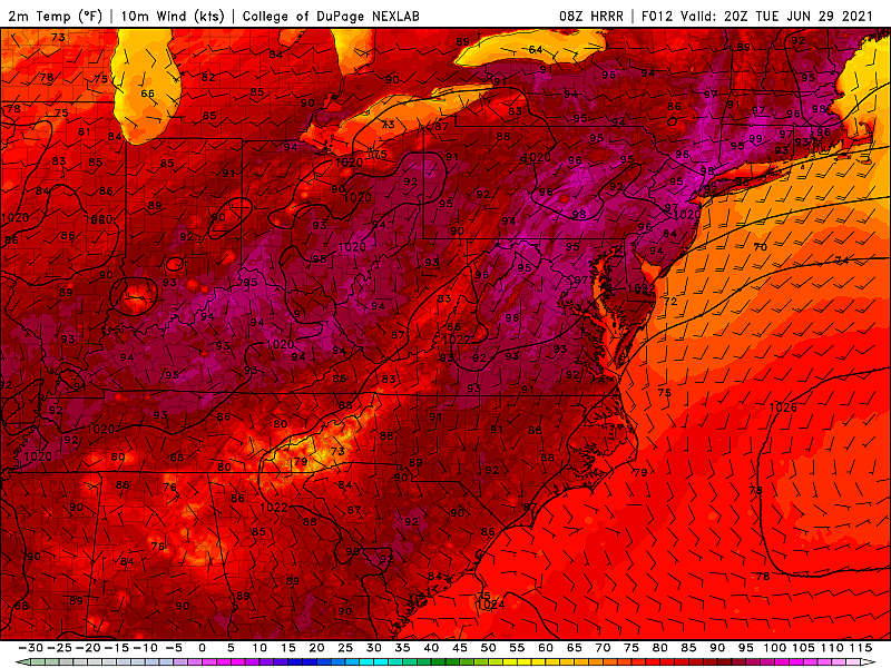
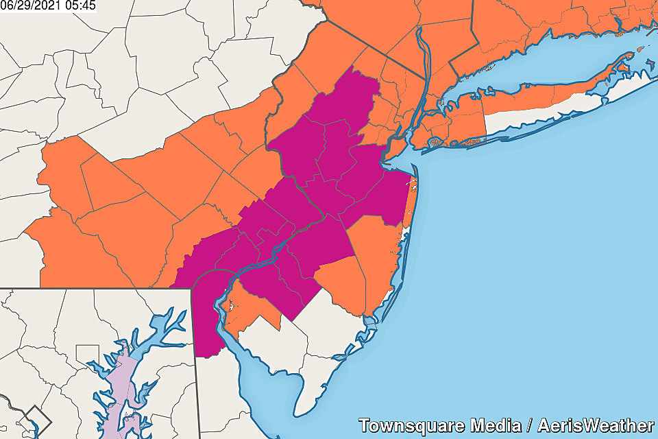
An Excessive Heat Warning has been issued for the heart of New Jersey, in effect until Wednesday evening. The warning covers Gloucester, Camden, NW Burlington, Mercer, inland Monmouth, Middlesex, Hunterdon, Somerset, and Morris counties. Tuesday afternoon, the heat index could soar as high as 105 degrees.
The Heat Advisory continues for Warren, Sussex, Passaic, Bergen, Essex, Union, Hudson, coastal Monmouth, Ocean, SW Burlington, and Salem counties. The heat index here could reach 95 to 100 degrees Tuesday afternoon.
Atlantic, Cape May, and Cumberland counties fall out of the warning and advisory at this point, as the heat index is expected to fall just shy of the technical criteria.
Skies will generally be mostly sunny and hazy. A stray shower or thunderstorm may impact northwestern New Jersey Tuesday evening. But the chance is low, and it would be very isolated.
Tuesday night will be clear and muggy, with low temps no cooler than the mid 70s. Yuck.
Wednesday
The last day of potentially dangerous heat and humidity.
High temperatures will once again soar into the lower to mid 90s. Even the beaches look hot this time around, with a more prominent southwesterly (land) breeze up to 20 mph.
A round of widespread scattered thunderstorms could cool things down temporarily Wednesday evening (after about 6 p.m.) Of course, with the heat (energy) and humidity (moisture), those storms could be quite strong.
Thursday
Ch-ch-ch-ch-changes are coming.
Thursday will start very warm and steamy. High temperatures will mainly hit 85 to 90 degrees. (North Jersey will start to taste cooler, less humid air, leading to temps only reaching the 70s.)
A cold front will drive in a round of steady, heavy rain starting around midday Thursday. Given the humidity in the air, and the tropical moisture stemming from the remnants of Tropical Storm Danny to the southwest, I think it's really going to pour buckets Thursday afternoon into Thursday night.
How much rain? 1 to 3 inches, perhaps. A thorough soaking.
Strong to severe thunderstorms are a possibility too.
While temperatures will plummet as soon as the first raindrops arrive, it looks like the humidity holds on. At least it will be "just sticky," rather than "steamy and tropical".
Friday & Beyond
There are still several scenarios in play in the "what comes next" game. While the heavy, steady rain should wrap up early Friday morning, I fear things could stay unsettled. That's due to a combination of 1.) semi-humid conditions remaining (with dew points in the 60s), and 2.) the aforementioned cold front stalling just to our south (providing a highway for additional storm systems.
So I think we're facing a few more batches of showers through Friday and Saturday (at least). That will combine with mostly cloudy skies and below-normal temperatures. My forecast currently puts highs in the 70s for Friday and Saturday.
I think the only washout period will be that initial Thursday to Friday morning time frame. The rest of the holiday weekend forecast is still very much up in the air. I think (and I hope) there's a real opportunity for warmer, brighter conditions as we get to Sunday the 4th and Monday the 5th.
And then I fully expect 90-degree temperatures to return next week.
Dan Zarrow is Chief Meteorologist for Townsquare Media New Jersey. Follow him on Facebook or Twitter for the latest forecast and realtime weather updates.
Every Video Game Movie Ever Made, Ranked From Worst to Best
Best spots to pick your own NJ strawberries
Gallery Credit: Erin Vogt
More From 94.5 PST


