From springlike back to wintry: NJ’s next storm could be an icy mess
The Bottom Line
As our latest rainmaker storm system wraps up Wednesday, we'll enjoy one day of ridiculous warmth. Temperatures will run 20+ degrees above normal for this time of year.
Cold air returns Wednesday night, setting the scene for our next storm system complex arriving Thursday. But don't call this one a "snow storm". Although several inches of snow accumulation are becoming more and more likely for North Jersey, a warm layer a mile above the ground spells an icing concern for most of the state. (And the south, we'll end with a period of just plain rain. The liquid kind.). Friday morning's commute will be the one to watch for slippery spots.
Near-Record Warmth: Wednesday
We are starting the day with temperatures near 60 degrees. That would be typical in June, not February! (Keep in mind, normal lows at this point of the year are still in the chilly 20s.)
We will hold on to warm temperatures all day, so you might be able to leave the jacket at home. (Personal preference, of course.) High temperatures will push into the 65 to 70 degrees range this afternoon. 20 degrees above normal. And close to record highs for the 23rd of February. (Records are 68 at EWR, 74 at TTN, 72 at ACY.)
Weather-wise, roads are damp with numerous puddles from Tuesday night's rain. And we're not quite done with raindrops yet — I have to leave a chance for spotty rain showers in the forecast through midday. Then substantial pops of sunshine will take over this afternoon. With a strong breeze, out of the west-southwest, gusting to 30 mph.
Cold Air Returns: Wednesday Night
Mother Nature snaps us back to reality with the arrival of a cold front late Wednesday. Its arrival will be dry. But a northwesterly wind will kick up, causing temperatures to tumble.
For most of New Jersey, I expect that cooldown to kick in at or after sunset. So we'd call Wednesday's temperature trend "diurnal" — the high temperature will be in the middle of the afternoon, where it belongs. The only exception: northwestern New Jersey, where thermometers may start to slide backward around 2 or 3 p.m.
By Thursday morning, temperatures will be below freezing across almost all of New Jersey. (Away from the immediate coast.) We'll average upper 20s.
Wintry Mess: Thursday-Friday
For several days, we've been cautioning that our weather could turn wintry and icy and messy from Thursday into Friday. And that forecast still holds true. With 36 to 48 hours to go until the storms peak, it's time to get serious about this one. And it's time to start dialing in more confident details.
—Appetizer... A first wave of energy will pass just south of New Jersey during the daytime hours on Thursday. A few showers could clip southern NJ. And with high temperatures barely above freezing, in the mid 30s, those showers could produce some light wintry mix. I am not overly concerned about accumulations or travel issues during the day Thursday. Just be aware it may not be a "pleasant" day.
—Storm Timing... The "main event" of this storm system will pass west to east through New Jersey between about 8 p.m. Thursday evening and Noon Friday. The brunt or peak of the storm will happen during the overnight hours, leading into Friday morning's commute. And then things will wrap up by Friday midday, with clearing skies and a stiff breezy through the rest of the day.
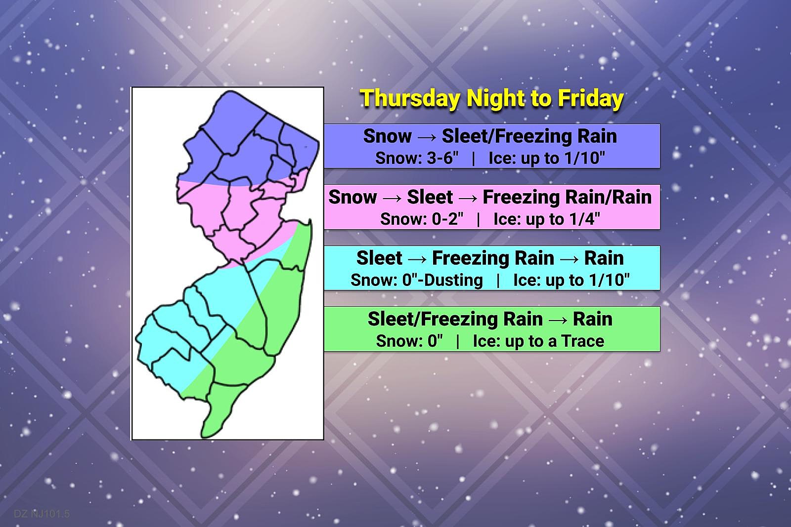
—Snow Accumulations... Limited. Northern New Jersey will be cold enough for a "mainly snow" scenario. With abundant moisture in play, 3 to 6 inches of accumulation seems to be a good possibility, especially along and north of the Interstate 80 corridor. North of I-195, there could be some initial snow and sleet accumulation, but that will quickly turn to slush, ice, and puddles by Friday morning.
—Ice Accumulations... Here's the real challenge for most of the state. Everywhere in the state away from the coast could see some icing due to sleet and freezing rain. I think my forecast map gives a good representation of how things will play out in regards to the ice accumulation potential. The "purple" and "dark blue" areas are of special concern for slippery conditions.
—Impacts... It is always harrowing when a winter storm directly impacts a rush hour. In this case, the Friday morning commute is of particular concern, especially across the northern half of the state. Even though snow and ice accumulations will fall in the "moderate impacts" category, that's enough to spark treacherous travel and huge headaches.
—Confidence... It is worth noting that models show colder air and heavier snowfall just north of New Jersey. I have accounted for that in my snowfall forecast. But if models do trend just a few degrees colder overall, our forecast impacts map may change pretty dramatically. Temperatures dictate precipitation type. And precipitation type (and intensity and duration) dictates accumulations. That's why winter weather forecasting is so challenging: the difference between 31, 32, and 33 degrees can make all the difference in cases like this.
—Winter Storm Watch... In anticipation of the snow/ice potential, the National Weather Service has issued a Winter Storm Watch for Warren, Sussex, western Passaic, and western Bergen counties from Thursday evening through Friday afternoon.
Weather Whiplash: The Extended Forecast
Our weather quiets down late Friday, with clearing skies and a stiff breeze. High temperatures will range from mid 30s north to mid 40s south.
Saturday looks unseasonably cold, with high temperatures near the freezing mark. It will be dry, with a mix of clouds and sun overhead.
Sunday will be the warmer day of the weekend, with highs in the 40s. There will be two opportunities for a stray rain/snow shower on Sunday too: A storm system passing south of NJ, and a frontal boundary pushing in from the northwest.
We flip right back to frigid weather on Monday. We may close out February with a "deep freezer" day, with high temperatures only around 30 degrees. A brisk wind would keep wind chills bitter as well.
What's Next?
I may or may not put together a full update Wednesday afternoon, as the Thursday-Friday storm comes into better focus. I'll post on social media and push out an app alert if there is any important info to add, by about 5 p.m.
I will definitely have another weather blog update Thursday morning, to be published in the 7 a.m. hour.
Until then, enjoy the sunshine and warmth while it lasts!
Dan Zarrow is Chief Meteorologist for Townsquare Media New Jersey. Follow him on Facebook or Twitter for the latest forecast and realtime weather updates.
Check out these 50 fascinating facts about dogs:
Gallery Credit: Linda Lombardi
LOOK: Food history from the year you were born
Gallery Credit: Joni Sweet
More From 94.5 PST


