
Mostly miserable Memorial Day Weekend weather for NJ: Soaking rain, raw wind, cold
The Bottom Line
2+ inches of rain. 30+ mph wind gusts. Temperatures stuck 20+ degrees below normal. Minor to moderate coastal flooding. Yuck.
Yes, this is unfortunately a pretty disgusting forecast for the first two-thirds of the Memorial Day Weekend. But there is one very bright spot: Monday. Memorial Day. I’m assuming most area parades and remembrance ceremonies are scheduled for Monday, which will clearly be the nicest day of the weekend. Let’s be sure to celebrate that piece of good weather, while never forgetting the true reason for Memorial Day.
Friday
It’s been a wild week of weather here in the Garden State - from cool to hot, from dry to storms. The grand finale will be a day that descends downhill quickly, as our next storm system arrives. If you have travel plans ahead of the 3-day holiday weekend, the earlier the better.
We’re starting off OK. Temperatures are mainly in the 60s to start your Friday. You might see some peeks of sun throughout the morning, as clouds continue to thicken up. Thermometers will probably hit mid to upper 60s Friday afternoon. (I can’t call that a “high” necessarily, because we were around the same point in the early morning hours.)
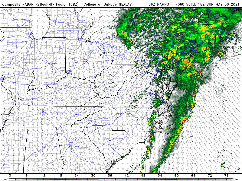
A shower may pop up as early as Noon or 1 p.m. Friday. Lunchtime. And then a more widespread and steadier band of rain will fill-in across New Jersey between about 3 p.m. and 7 p.m. Dinnertime.
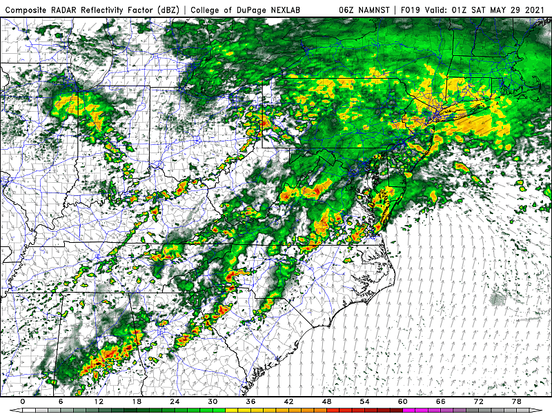
We are going to get soaked Friday night, as the heaviest rain of the entire weekend moves through NJ. Between about 6 p.m. Friday and 4 a.m. Saturday, bands of heavy rain will combine with 30 mph wind gusts. No severe weather. Minimal thunder. Just driving rain and wind.
Visibility and traction will be difficult, and there could be ponding or flooding issues as rainfall inundates storm drains.
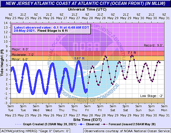
There is one additional concern for the weekend: a Coastal Flood Advisory for the Jersey Shore. This is “King Tide” weekend, with one of the highest astronomical tides of the year. Unfortunately, that will combine with the on-shore winds and stormy conditions here.
Minor to moderate category flooding is expected along tidal waterways for three consecutive high tide cycles: Friday night, Saturday morning, and Saturday night.
Saturday
Just plain yucky.
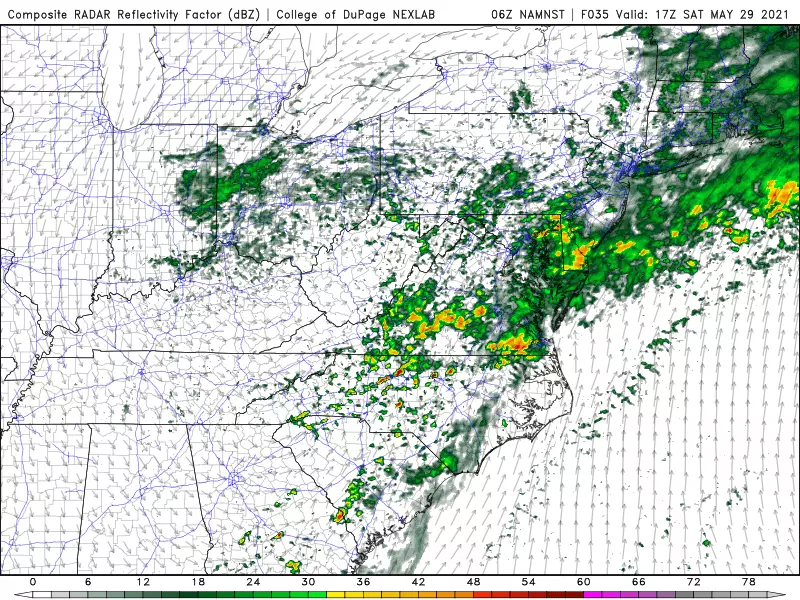
The really wet weather looks to continue through about mid-morning Saturday (9 or 10 a.m.) before precipitation breaks apart a bit. We might even get substantial pockets of dry weather by Saturday afternoon.
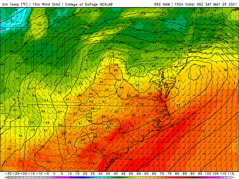
However, regardless of how many raindrops are actively falling from the sky, it’s going to stay pretty miserable. Damp and cloudy. Breezy and cool. High temperatures will only reach about 50 to 55 degrees, at best.
Model consensus points toward another batch of steady-ish pushing past New Jersey Saturday night into Sunday.
Sunday
No big changes. The chance of rain continues, although we’ll hopefully see a drying trend late-day.
Yet again, temperatures will barely budge, with both high and low temperatures within a few degrees of 50.
By the time raindrops exit the Garden State for good this weekend, rainfall totals will probably range from 1.5 inches (South) to 2-3+ inches (Central/North). That’s impressive. And healthy too. 100 percent of the state is now classified as “abnormally dry,” a precursor to a full-blown drought - this rain should dramatically improve those conditions.
Memorial Day Monday
The one bright spot of the 3-day weekend. As skies break into sunshine, high temperatures will warm into the lower 70s across most of the state. (Slightly below normal, but who cares.)
The Extended Forecast
Tuesday should be a pleasant to June, with partly sunny skies and 70s.
We’ll likely warm closer to 80 degrees on Wednesday. However, the long-range forecast currently shows an extended period of unsettled weather. At the moment, I would put mostly cloudy skies and occasional rain in the forecast for late Wednesday through next Saturday, as several impulses ride through New Jersey’s atmosphere. As always, we’ll try to time that active forecast out as it gets a bit closer.
That’s it! Hopefully you have some nice indoor activities planned throughout the Memorial Day Weekend. Please be smart and stay safe. The CMDZ weather blog will return on Tuesday - the first day of June, the first day of Atlantic hurricane season, and the first day of climatological summer!
Dan Zarrow is Chief Meteorologist for Townsquare Media New Jersey. Follow him on Facebook or Twitter for the latest forecast and realtime weather updates.
The Tastiest Jersey Shore Food Trucks You Should Try This Summer
Gallery Credit: Jimmy G
LOOK: Here are the 50 best beach towns in America
Gallery Credit: Keri Wiginton
More From 94.5 PST


