
NJ weather: Fred remnants exit, now watching Tropical Storm Henri
UPDATE... This article is outdated...
For the latest storm forecast information, please refer to my newest weather blog post.
The Bottom Line
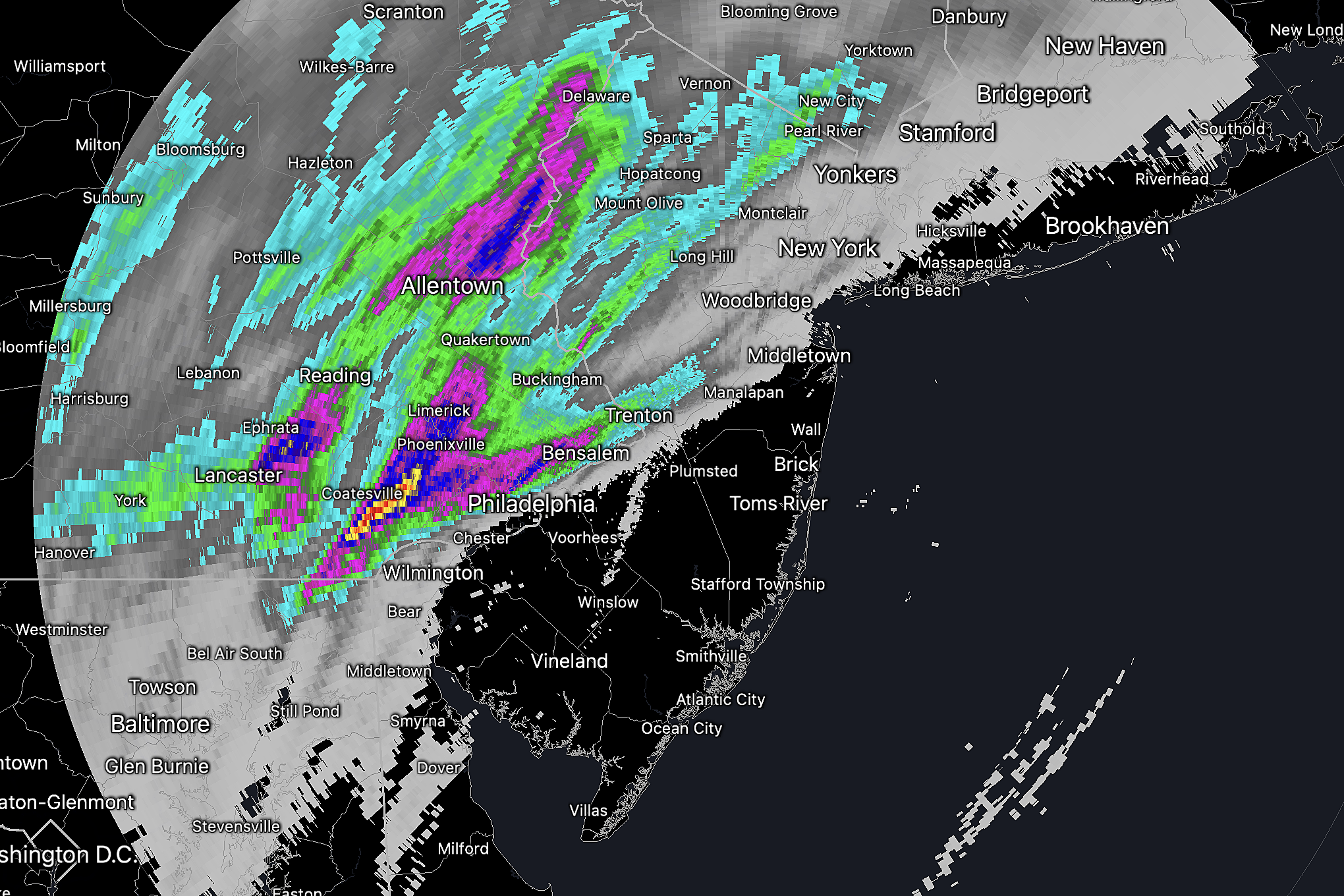
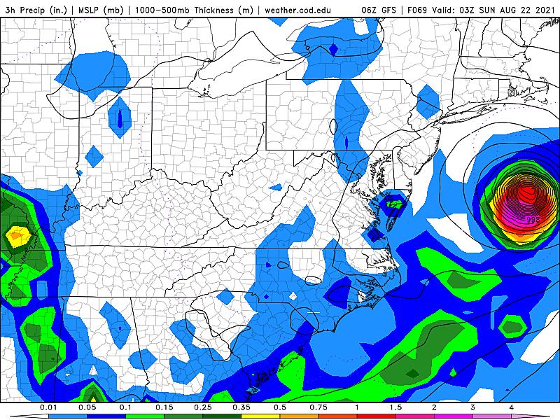
What a dramatic, tropical night. For part of New Jersey, at least. According to radar, over 3 inches of rain fell over Warren County, New Jersey overnight. Just west of Philadelphia, over 6 inches! Multiple tornado warnings, flash flood warnings, and blinding rain.
On the flip side, from Monmouth County to the bottom of the state? Hardly anything at all, spared the drama and thorough soaking.
The unsettled weather continues for the next few days, as we end up sandwiched between two storm systems. A trough to the southwest will keep rain chances in the forecast. And Tropical Storm Henri (on-REE') out in the Atlantic will cause rough surf and rip current concerns, in addition to enhancing those rain chances through the weekend.
Thursday
As of this writing (5:30 a.m.), NJ's rain is almost completely done, as Fred's remnant low heads into New England. The rest of Thursday looks mainly dry, although a few spot showers and thunderstorms may pop up later on.
Otherwise, the day begins with clouds and downright tropical humidity. Where it didn't rain, temperatures are hovering very close to 80 degrees - yuck! We will see substantial breaks of sun and blue sky by Thursday afternoon. It will be a very warm and humid summer day, with high temperatures between about 85 and 90 degrees.
Headed to the beach? A moderate risk of rip currents is already posted as Henri churns up the Atlantic. (More on that later.)
Thursday night looks partly cloudy, warm, and muggy. Low temperatures will only drop into the lower 70s. Both highs and lows here are hovering about 5 degrees above seasonal normals.
Friday
Still unsettled. There is a relatively wide spread of model solutions for Friday, but most of them include scattered showers and thunderstorms. The best chance for periods of rain seems to be in the southern half of the state, during the daytime hours.
Our severe weather risk should remain low, with abundant cloud cover and limited heating of the atmosphere. There could be some splashes of heavy rain - if that happens on an already-soaked ground, ponding and flooding issues could occur quickly.
Where it rains Friday, high temperatures will only reach about 80 degrees. Where it doesn't, the thermometer should climb closer to 85.
Saturday
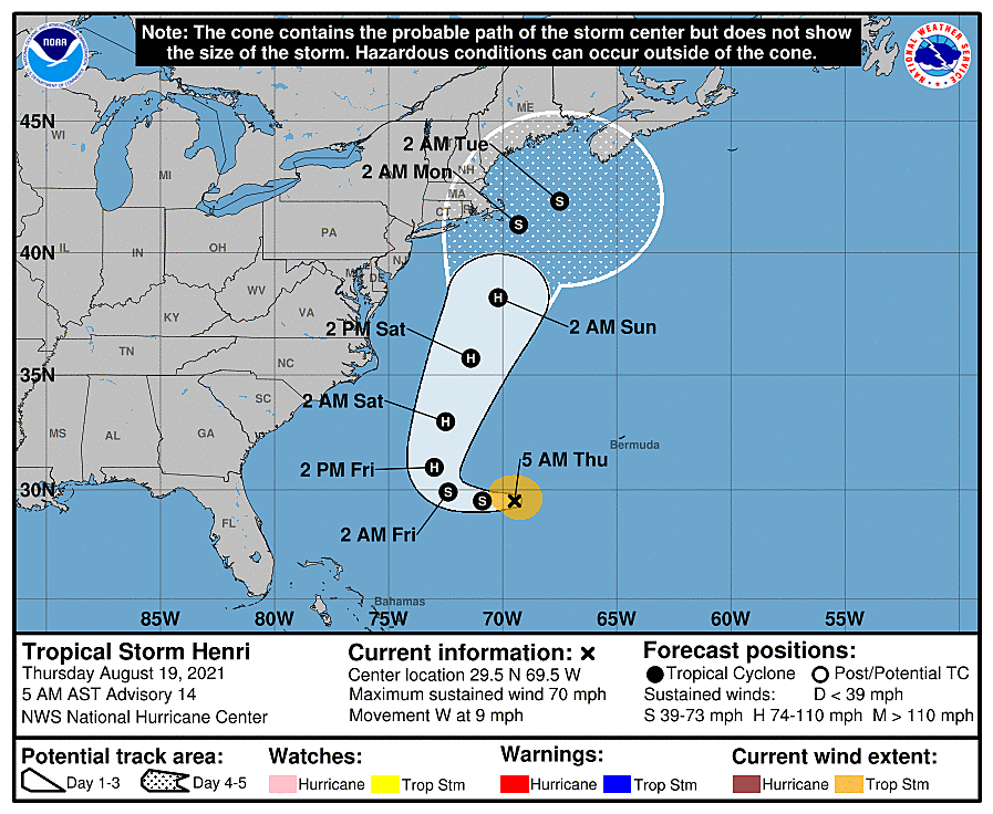
Here's where the impacts of Henri kick in. There was one recent model run that made my heart stop, wiggling the storm significantly closer to New Jersey. (Even putting NE NJ in the National Hurricane Center's forecast cone of uncertainty - yikes!)
But the consensus track remains consistent, keeping the center of Henri about 200 to 300 miles east of New Jersey. It will likely be a category one hurricane at that point. The worst wind and rain will be limited to the inner 50 to 100 miles of the storm. (And we're on the weaker, drier side anyway.)
So as long as Henri doesn't significantly wiggle again, the Jersey Shore will be safe from a "direct" hit.
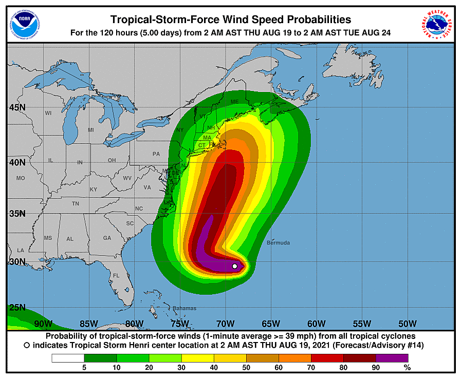
However, dangerous rip currents and rough surf will absolutely be a concern - likely a "high risk" posted for Friday, Saturday, and Sunday. And we could see some enhanced rain chances through the weekend too.
Confidence is low as to the exact timing and position of rain bands this weekend. It looks like we could see a few showers on Saturday, but there will be completely dry periods too. With mostly cloudy to overcast skies, high temperatures will be limited to the lower 80s or so.
Sunday
From Saturday night into early Sunday, Henri itself could spit some showers toward NJ. Then the sky will probably brighten. It will probably stay breezy for the first half of the day too. Model guidance puts highs in the above-normal upper 80s to close out the weekend.
The Extended Forecast
The long-range forecast shows our next heat wave is on the way for next week. Widespread 90s are expected (away from the coast) for at least Monday, Tuesday, and Wednesday. Minimal rain and thunderstorm chances each day (although not zero). Under partly sunny skies.
The GFS model favors a cold front late next week, around Thursday or Friday. That will hopefully knock down temperatures and also provide welcome relief from these weeks of high humidity.
Dan Zarrow is Chief Meteorologist for Townsquare Media New Jersey. Follow him on Facebook or Twitter for the latest forecast and realtime weather updates.
BEEP BEEP BEEP: These are the 13 types of Wireless Emergency Alerts auto-pushed to your phone
Gallery Credit: Dan Zarrow
Census 2020: The 20 biggest places in New Jersey
Gallery Credit: Michael Symons
More From 94.5 PST


