NJ weather: Ice/rain storm exits, next winter storm only 48 hours away
UPDATE... This article is outdated...
For the latest winter storm forecast information, please refer to my newest weather blog post.
The End of Ice/Rain
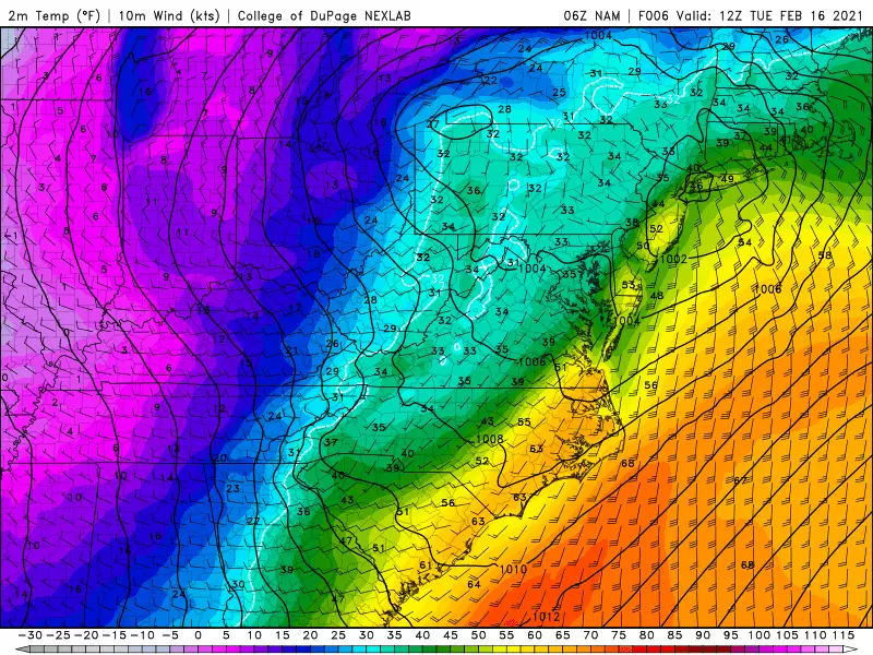
Monday night's storm system played out pretty close to expectations. It was an icy scene in northwestern New Jersey. And a very icy scene in and around Sussex County, with upwards of 0.34" of ice accumulation reported early Tuesday morning. Meanwhile, as temperatures through central and southern New Jersey soared into the 40s and 50s, we saw a period of soaking rain. (My ride to work was an adventure in hydroplaning.)
A few things to keep in mind for Tuesday morning's commute:
—There are numerous accidents and power outages in NW NJ, due to the icy conditions. The icing won't last long, as temperatures are already at or above the freezing mark.
—In the "rain zone," conditions are obviously very wet. Visibility and traction will be reduced.
—Road ponding and flooding (i.e. big puddles) are possible where storm drains are blocked by snow/ice.
—Rain is a very efficient snow melter. That adds to the potential ponding issues.
Rain will taper off between about 7 a.m. and 10 a.m. Tuesday. And then we'll break into sunshine by the afternoon. We will squeeze out a few hours of mild, pleasant weather. High temperatures will range from the lower 40s (North Jersey) to mid 50s (South Jersey). FYI, record highs are in the 70s — it's not even close.
The Return of Cold
Starting around mid afternoon Tuesday (3 p.m.), arctic air will be knocking on New Jersey's front door yet again. So temperatures will nosedive heading into Tuesday night, with a stiff northwesterly breeze (perhaps gusting to 30 mph).
The big concern will come around 7 p.m. Tuesday evening, as temperatures tumble below the freezing mark. Any wet surfaces or puddles left from the early morning rain and/or snow melt will absolutely flash freeze overnight.
Thermometers will bottom out in the lower 20s. The wind chill ("feels like" temperature) will easily drop into the teens. Back to "bundle up" weather!
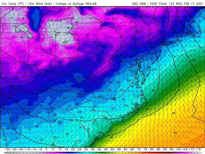
Wednesday's high temperature will only reach the lower 30s. Back to the cold side, but at least it will be dry and issue-free. Early sunshine will give way to late-day clouds.
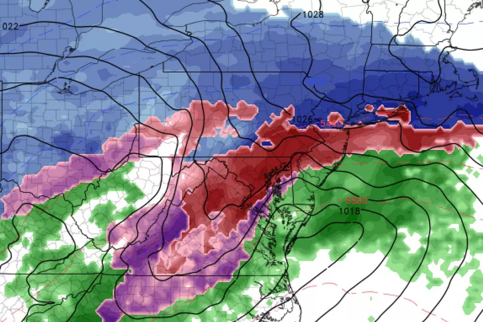
Another Wintry Mess
Our next storm system, yet another nor'easter, will arrive sometime on Thursday, lasting through sometime Friday.
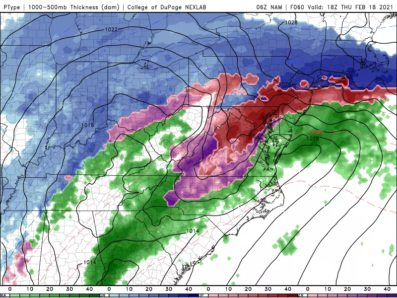
I am going to hold off on drawing a snow/impacts map until Tuesday afternoon. But here are a few nuggets of insight for now:
—A wintry mess... The most likely scenario seems to be a progression from (potentially heavy) snow to icy mix to rain. The speed of that transition will obviously dictate what ends up on the ground.
—Timing troubles… There are some notable differences among forecast models regarding timing of the start and the peak of this system. I remain very concerned that we'll face the sloppiest weather during the daytime hours, leading to deteriorating conditions between the morning and evening commutes.
—Pouring snow? The NAM model is particular bull-ish on very heavy snow at onset Thursday morning, leading to quick accumulations and icy roads.
—Another ice-maker? A common theme amongst the model guidance is an intrusion of warm air about 1 mile overhead. As we've discussed countless times in the last week, that "warm nose" situation is a classic sleet/freezing rain setup.
—The big question... Will snow or sleet win out as the storm ramps up? If snow, we could see a wide swath of 6+ inches of accumulation, especially to the north. If the forecast leans icier, we could see a swath of 0.20" of accretion, especially through the middle of the state.
—Down the Shore… With a period of northeasterly (on-shore) winds, tidal guidance is picking up on about a foot of surge. That's enough to cause minor category flooding of tidal waterways for one or two high tide cycles.
—The end… I'm pretty confident this system will end with a period of rain Friday morning.
Peace and Quiet
I guarantee no one in the state of New Jersey is more eager for quieter weather than yours truly. Friday will mark 33 consecutive days of work — not unusual for wintertime, but that doesn't mean I like "the grind".
I remain optimistic that our hyperactive weather pattern will go away after the Thursday-Friday storm. Quieter weather doesn't necessarily mean pleasant though. While sunshine should win the sky for the upcoming weekend, high temperatures on Saturday and Sunday will be stuck in the 30s at best.
A clipper system will drive in some minor snow and rain on Monday, with light accumulations possible in North Jersey. Temperatures should moderate next week, with highs popping back into the 40s.
Next weather blog update on Thursday's wintry mess is expected Tuesday late afternoon. See you then.
Dan Zarrow is Chief Meteorologist for Townsquare Media New Jersey. Follow him on Facebook or Twitter for the latest forecast and realtime weather updates.
LOOK: Here are 25 ways you could start saving money today
Gallery Credit: Bethany Adams
More From 94.5 PST


