
NJ weather: Two more days of unseasonably cold temperatures
The Bottom Line
Monday's weather was just ridiculous. Even in the middle of winter, it would have been unusually, uncomfortably cold. And the snow squalls were intense at times too.
We will see improvements on Tuesday. And Wednesday will be about 5 degrees warmer. (Although some raindrops and snowflakes are possible there too.)
The big warmup is coming on Thursday. But it may turn into a wild weather day, as scattered showers and gusty thunderstorms roll through the state.
Tuesday
Still cold. Still breezy. We're starting the day with temperatures in the 20s — we're actually within a few degrees of record low temps for the 29th of March. Plus, a biting wind chill in the teens will smack you in the face.
Once again, you'll want to dress as you would in the middle of January.
Let's talk about those improvements, compared to Monday:
1.) No snow showers or snow squalls. Maybe a flurry.
2.) Bright sunshine all day, helping to cut through the chill.
3.) The northwesterly wind will be calmer, but still in the "breezy" range.
4.) Temperatures will end up about 5 degrees warmer.
Highs should reach about 40 degrees Tuesday afternoon, give or take. But the wind chill (the "feels like" or "apparent" temperature) will sting, closer to 30 degrees.
Another statewide freeze is expected Tuesday night, with lows falling into the mid 20s. Clouds will increase through Wednesday morning, but our weather will stay dry.
Wednesday
Thermometers will go a little higher, pushing into the mid 40s. But that's still not very springlike — and notably below normal for late March.
Look for clouds and some sun and Wednesday. Winds will be much lighter too.
A weak impulse will try to push from west to east across New Jersey centered around the late morning hours Wednesday — let's say 8 a.m. to 1 p.m. Temperatures both at the surface and in the "snow growth zone" about a mile up in the atmosphere will be close to the freezing mark. So there a mix of snowflakes, ice pellets, and raindrops could fall. (Probably leaning toward snowflakes to the north and raindrops to the south.)
However, that mixed precipitation will be battling some very dry air over New Jersey. Most model solutions have it fizzling considerably as it pushes through. So this is not a slam dunk, and really not a big deal. Wintry mix intensity will be light, if anything at all. And I am not concerned about accumulations or significant travel issues.
Thursday
Much much warmer and more springlike, as high temperatures push into the mid-upper 60s.
However, the surge of warmth and higher humidity will contribute to a rather unsettled weather day. Skies will be mostly cloudy. Spotty rain showers are possible in the morning. And then scattered thunderstorms are likely later on.
Those late-day storms — in the afternoon and especially evening hours — will probably be on the strong side. The big concern is that they tap into a strong low-level jet — screaming fast winds about a half-mile above-ground, which could mix down to the surface in heavy rain. It's not a perfect setup, but the wind threat is high enough to warrant ringing some alarm bells. (Hence the "yellow alert" icon on my 5 Day Forecast.) There could be some localized downpours out there too.
Geographically, the biggest concern for the development of severe thunderstorms will be to the south and west. Timewise, the best chance of storms will coincide with the dinnertime hours, around early evening.
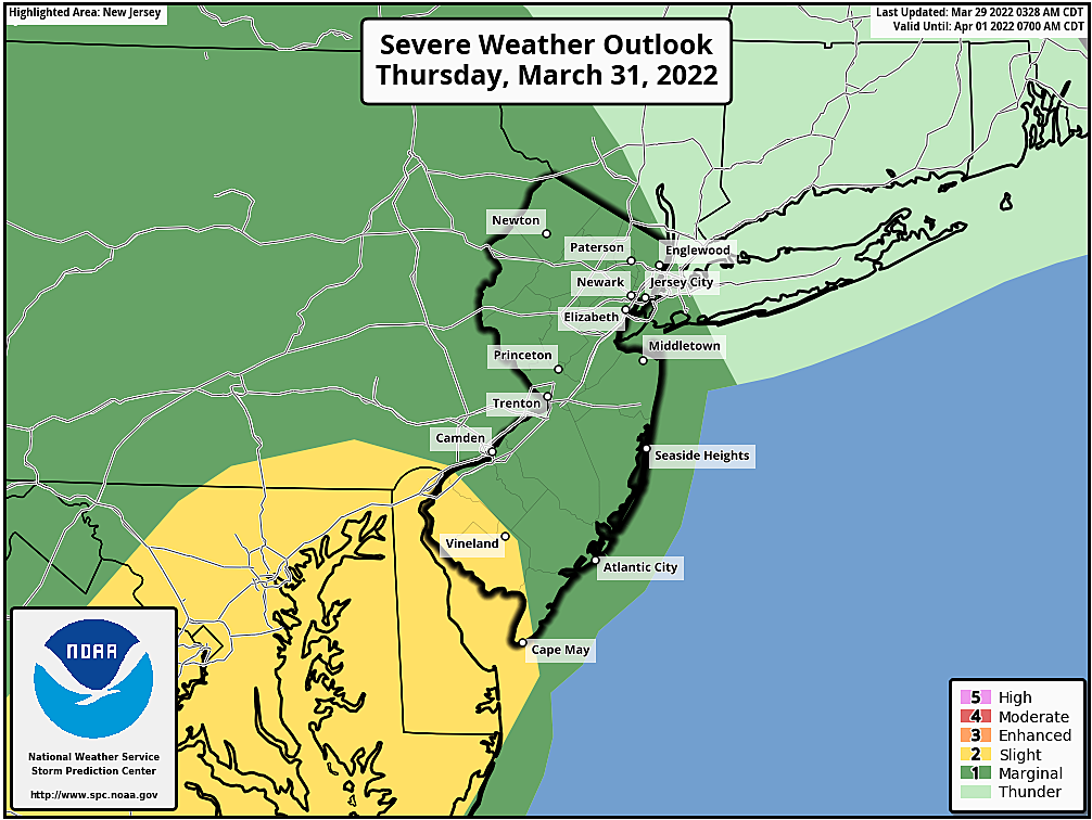
Bottom line: If you have outdoor plans or travel plans on Thursday, you'll want to keep a close eye and ear on this forecast.
Friday & Beyond
The warm, windy weather will come to an end with the passage of a cold front early Friday morning. The ensuing cooldown won't bring an arctic blast, per se — it'll just drop us back to seasonable, near-normal temperatures for the first weekend of April.
Temperatures on Friday will fall from the mid-upper 50s in the morning, into the 40s by the afternoon. A fierce westerly wind will blow too, sustained at 15 to 25 mph, with gusts to 35 mph. The day looks mainly dry, although I can't rule out a stray shower.
Saturday looks fine. Partly sunny and mid 50s. A typical early April day.
Our next chance of rain will come along on Sunday. Whether it's a "morning only" or "all day" kind of drizzle, I'm not sure. But once again, temperatures will be seasonable and reasonable, in the lower to mid 50s or so.
You can probably tell I am not happy about our recent cold snap. While I'm pretty confident it won't get this cold again any time soon, we're not necessarily done with occasional freezes and snowflakes yet. Spring is still early, and big temperature swings are very much commonplace throughout the month of April.
Dan Zarrow is Chief Meteorologist for Townsquare Media New Jersey. Follow him on Facebook or Twitter for the latest forecast and realtime weather updates.
2022 Seaside Heights Polar Bear Plunge photos
Gallery Credit: Andrew Miller/For Townsquare Media NJ
Inside ISLAND Waterpark, coming soon to Atlantic City
Gallery Credit: Joe Votruba
More From 94.5 PST


