NJ’s first cold front of Fall: When, how much rain, and how cool?
The Bottom Line
The quick answers to the questions posed in the headline: 1.) Thursday. 2.) Between 0.75" (coast) and 2.25" (NW NJ). 3.) Morning 50s, afternoon 70s.
As we bid a fond farewell to summer and welcome the Autumnal Equinox at 3:20 p.m. Wednesday, we are looking ahead to the first front of fall. Everyone in New Jersey will get soaked eventually. And there could be some wind and flooding issues.
But there is a payoff, as we "fall" back into a delightfully dry air mass by this weekend.
Wednesday
We've got a case of the muggies. It is an unusually warm start to the final day of summer, with temperatures averaging 70 degrees — that is 10 to 15 degrees above normal for the 22nd of September.
And it will be a warm and humid day overall. High temperatures will pop to about 80 degrees. That's 5 to 10 degrees above seasonal norms.
It will be breezy too, with a southeasterly wind peaking at 25 mph. That wind is a contributing factor to some rough surf along the Jersey Shore. A high risk of rip currents is posted for both Wednesday and Thursday, with ocean wave heights up to 4 feet.
The sky will remain somewhat murky over New Jersey throughout Wednesday. Let's call it mostly cloudy. In addition, a few showers may creep into the western half of the state as the day goes on. Even so, I think it's still fair to call it a "mainly dry" day.
The shower chance will continue Wednesday night. And it will still feel muggy too, with lows again only falling to about 70 degrees.
Thursday
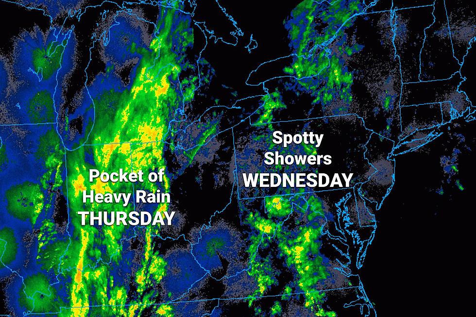
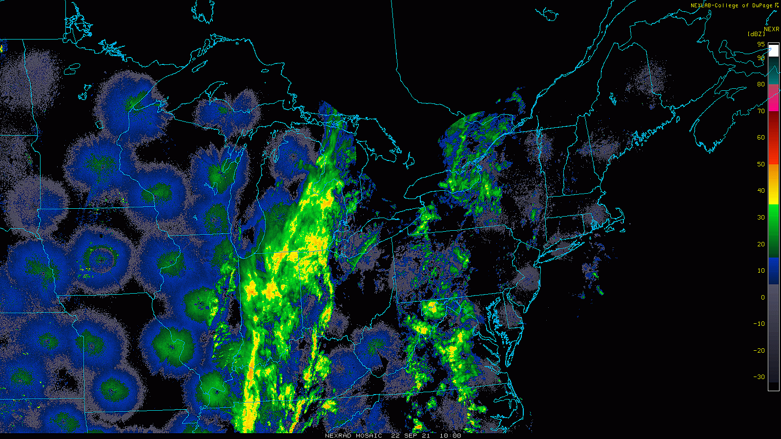
Cold front day. It will get wet, if not nasty, for a time. Although I do not expect it to rain all day long.
There are still significant differences in "main event" timing among our primary forecast models. The GFS still stands along as the "faster arrival, slower passage" solution, pushing through moderate to heavy rain from Thursday mid-morning through Thursday evening. The Euro and NAM are much later, holding off the heaviest rain until Thursday evening.
I still favor the later timeline — but admittedly, there could be raindrops over New Jersey at any point in time on Thursday.
The models do agree on the magnitude of rainfall, putting the bullseye over the northwestern corner of the state. Warren-Morris counties, to be exact.
Rainfall totals in northwestern New Jersey are forecast to top two inches. On the flip side, we'll probably come up just shy of an inch closer to the coast.
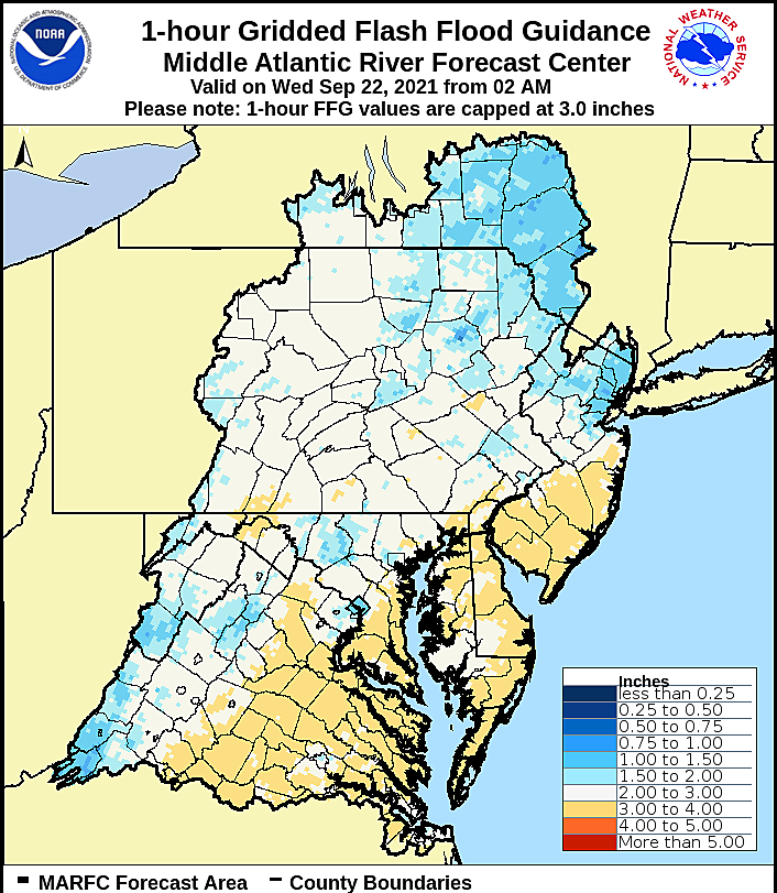
So will it flood? Maybe a little bit. 6-hour Flash Flood Guidance is holding at 3+ inches for North Jersey — that is the approximate amount of rain required for significant, widespread flash or river flooding to occur. And I think we'll stay below that benchmark, statewide. However, the 1-hour thresholds are only about an inch. That makes me think that low drainage flooding and road ponding are possibilities, while it pours (and shortly thereafter).
The National Weather Service agrees, issuing a Flash Flood Watch for 7 NJ counties: Sussex, Warren, Morris, Hunterdon, Somerset, Mercer, and Middlesex. That watch is in effect specifically from Thursday afternoon through Friday morning.
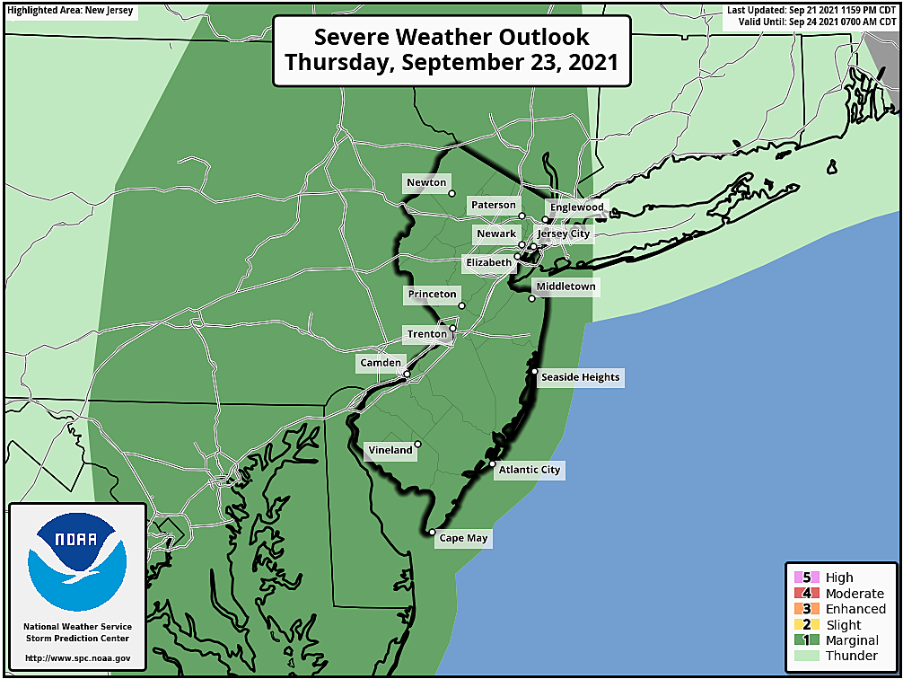
Additionally, there is a slight chance of severe weather (gusty winds), especially in the late afternoon and early evening window.
Thursday's temperature forecast is pretty much a guess, as it will be heavily affected by the intensity of rainfall and clouds. The vast majority of New Jersey should hold in the 70s for most of the day.
Friday
Two big transitions will happen early Friday morning. Number one, rain showers will come to an end. (By about 9 a.m. at the latest.) Number two, dew points will drop dramatically as our new air mass arrives behind the cold front. That dry-out will happen just after Midnight to the west, and just after sunrise to the east.
Skies will quickly clear to sunshine by midday Friday, and the rest of the day looks great. High temperatures will settle in the comfortable lower 70s.
The Weekend & Beyond
The first weekend of fall and the final weekend of September look pretty fantastic. Partly sunny and lower 70s on Saturday. Mostly sunny and lower 70s on Sunday.
The dry pleasant weather will continue for early next week, with highs probably bumping into the seasonable mid 70s. Next widespread rain chance holds off until late Tuesday, at the earliest.
Dan Zarrow is Chief Meteorologist for Townsquare Media New Jersey. Follow him on Facebook or Twitter for the latest forecast and realtime weather updates.
The best cheeseburgers in New Jersey
Gallery Credit: Steve Trevelise
Hottest 2021 toys that might see price hikes
Gallery Credit: Jeff Deminski
More From 94.5 PST


