
Severe storms possible in NJ Tuesday: Wind and hail biggest concerns
The Bottom Line
We've had some truly delightful weather days lately — sunny, dry, and relatively warm. That comes crashing to the ground on Tuesday, with some raindrops and crashes on thunder. Severe weather is a possibility, especially damaging winds and hail. But at least this will be our one and only one unsettled and stormy day of the week.
Behind Tuesday night's cold front will come a cooldown. Fall will be in the air as we prepare to turn the calendar page from September to October.
Tuesday
Carry the umbrella and keep an eye on the sky.
The big mechanic in New Jersey's weather forecast Tuesday is an approaching cold front. That boundary line between warm, humid air and cool, dry air will cause significant atmospheric lift. And that will cause thunderstorms.
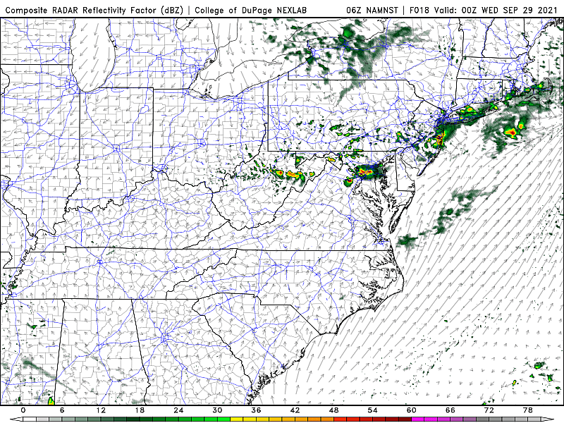
It looks like we'll face two or three waves of rain Tuesday, ahead of that frontal passage coming late Tuesday night.
As of this writing (5:30 a.m.), our first raindrops of the day are falling in northwestern New Jersey. This initial round of scattered showers will affect primarily northern and central NJ through the morning hours.
Despite the threat of rainy, stormy weather, you will see some breaks of sun throughout the day. It will be fairly warm and humid. You can probably skip the sweater or jacket Tuesday morning, with temperatures mainly in the 60s. And we'll see high temperatures between about 75 and 80 degrees Tuesday afternoon.
The big thing to watch will be the "grand finale" wave of thunderstorms from Tuesday late afternoon through evening. Let's say 4 p.m. to Midnight.
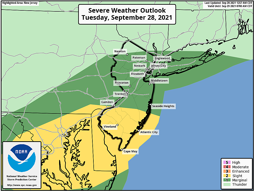
Southern New Jersey will feature the warmest temperatures and juiciest air in the state. Therefore, that's where the strongest storms are most likely to form. (Possibly stretching into Central Jersey too.)
Given the abundant instability and shear, I am most concerned about damaging winds accompanying Tuesday evening's storms. Hail is also a possibility. The risk for flooding rain and tornadoes is low.
After Midnight, any rain will be pushed off the coast as the front itself introduces cooler, drier air once again. Quite possibly the coolest, driest air of the season so far. (You'll hear me say that a lot over the next few weeks — that's what fall is all about!)
Low temperatures will mainly dip into the mid 50s by daybreak Wednesday morning. Northwestern New Jersey will probably return to the 40s.
Wednesday
Sunshine returns. But temperatures will be quite autumnal, with highs only in the upper 60s to around 70 degrees. That is firmly below normal for late September — more reminiscent of early October.
Thursday & Beyond
The weather will stay dry, the air will be crisp, and skies will be bright. Daily low temperatures will be in the 40s/50s. (NW NJ may come close to frost territory by Friday morning, although current forecast models keep temps at or above 40.) High temperatures will primarily be stuck in the mid to upper 60s.
Our next storm system is scheduled to arrive late Sunday night into Monday. Rain chances have wavered between meager and nuisance. We'll keep an eye on that to see how the timing and impacts picture shakes out.
The tropics are still on fire too. Major Hurricane Sam is spinning in the middle of the Atlantic Ocean, about 2,000 miles southeast of New Jersey. It is expected to curve out to sea, tracking just east of Bermuda. But that may be close enough for a resurgence of rip current, rough surf, and beach erosion concerns. No weather issues though.
There are two more tropical waves behind Sam. The next (final) two names on the 2021 Atlantic hurricane list are Victor and Wanda.
Dan Zarrow is Chief Meteorologist for Townsquare Media New Jersey. Follow him on Facebook or Twitter for the latest forecast and realtime weather updates.
BEEP BEEP BEEP: These are the 13 types of Wireless Emergency Alerts auto-pushed to your phone
Gallery Credit: Dan Zarrow
Things to do in Salem County, NJ
Gallery Credit: Dino Flammia
More From 94.5 PST


