Severe T-Storm Watch for NJ until 8pm: Intense wind and rain, tornado possible
UPDATE as of 3:45 p.m. Monday...
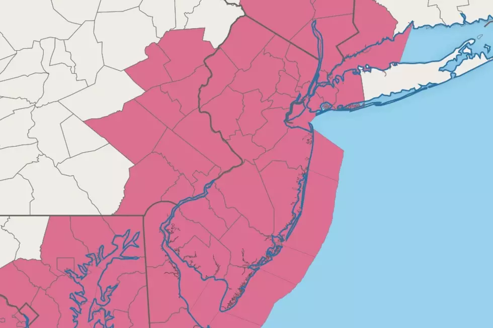
A new Severe Thunderstorm Watch was issued, that now includes previously excluded Salem, Cumberland, and Cape May. The text below and associated maps have been updated accordingly.
ORIGINAL/EDITED POST from 1:43 p.m. Monday...
Warmth + Humidity + Lift (Cold Front) = Thunderstorms.
New Jersey's streak of summerlike warmth is about to end with a 'bang'. A cold front will spark strong to severe thunderstorms Monday afternoon and evening. And unfortunately, the nastiest weather will coincide perfectly with Monday evening's commute.
The National Weather Service and Storm Prediction Center have issued a Severe Thunderstorm Watch for all of New Jersey's 21 counties. The watch is in effect until 9 p.m. for Salem, Cumberland, and Cape May counties in far southern NJ. The rest of the state is under a watch until 8 p.m. Monday evening.
A "watch" serves as a formal heads-up that potentially dangerous, potentially damaging weather may occur. Watches cover a broad geographical area, for a wide time window of several hours. If severe weather becomes imminent — 58+ mph wind gusts, quarter-sized hail, flooding or tornadoes — much more specific and urgent warnings will be issued.
I provided a full forecast rundown for Monday and beyond in my early morning weather blog post.
Here is a bulleted list of what to expect from Monday's storms:
—Timing? Spotty strong thunderstorms will crash into western NJ around 2 or 3 p.m. Monday, generally moving from southwest to northeast. The biggest, most widespread push of wind and rain will probably happen a bit later, in the 4-5-6 p.m. time frame. Storms should pulse down in intensity and exit the state around sunset, 8 or 9 p.m.
—Geography? Based on timing and atmospheric parameters, Monday's strongest storms will be found across the western half of New Jersey. The western edge of the state - i.e. counties adjacent to the Delaware River - are prone to experience the nastiest storms here.
—Biggest Concern #1? Wind. A squall line driven by a cold front is a notorious wind machine. Gusts over 40 mph are likely — that's the threshold to call it a "strong" thunderstorm. A few severe wind gusts over 60 mph are possible.
—Biggest Concern #2? Heavy rain, leading to ponding and flooding. An inch of rainfall in a short period of time is more than enough to produce ponding or flooding in poor drainage and low-lying areas. And coinciding with the evening commute, traffic could really get snarled in downpours.
—Other Concerns? By definition, every thunderstorm contains lightning and is therefore potentially dangerous. There is also a chance for hail and a tornado or two from this storm system, especially from the initial (supercell) thunderstorms that form Monday afternoon.
Remember, the safest place to be during a thunderstorm is inside a sturdy building. Pay attention to changing weather conditions, and be prepared to alter your plans if things turn dangerous. Never attempt to walk, swim, or drive through flooded areas. In the end, common sense goes a long way — stay smart, be safe.
Stick with us — online and on-air — for the latest on this turbulent weather transition.
Dan Zarrow is Chief Meteorologist for Townsquare Media New Jersey. Follow him on Facebook or Twitter for the latest forecast and realtime weather updates.
BEEP BEEP BEEP: These are the 13 types of Wireless Emergency Alerts auto-pushed to your phone
Gallery Credit: Dan Zarrow
TIPS: Here's how you can prepare for power outages
More From 94.5 PST


