Winter Storm Watch for NJ: A tricky, snowy, windy, cold forecast
UPDATE... This article is outdated...
For the latest winter storm forecast information, please refer to my newest weather blog post.
The Bottom Line
I'm kinda stumped. Here we are, 36 to 48 hours from the arrival of a powerful nor'easter, set to bury New Jersey in snow.
Well, it might. Sigh.
I was hoping we would have a more definitive consensus developing by now. There are some clear trends amongst model guidance, strongly suggesting heavy (6+ inches) and even significant (12+ inches) snowfall for part of New Jersey (mainly along the coast). However, it's still a very precarious call, because even a shift of 25 to 50 miles east would create a very different scene over New Jersey with much lower snow totals.
So it's a touchy snow forecast, with outcomes ranging from hardly anything to shovelable to plowable to crippling. But let's not forget the other storm impacts too: the wind, minor coastal flooding, and some dangerous cold. What a wintry weekend it will be.
A Precarious Forecast
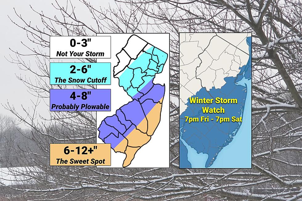
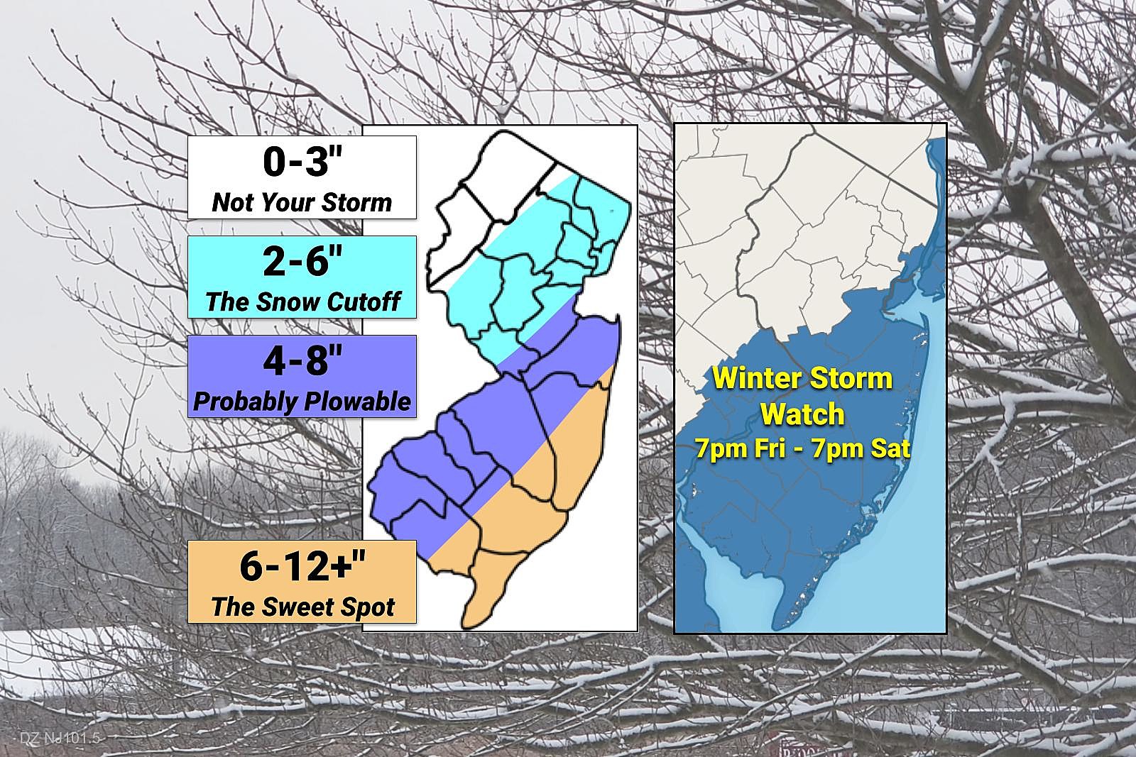
I crafted my "first stab" snow forecast map as a "most realistic" representation of how the coastal storm will play out over New Jersey. I'm ignoring the "massive blizzard" possibilities, for now. I've put aside the "complete miss" scenario too, for now. (Although neither of them are completely off the table.)
As I stared at and analyzed the latest guidance, the following four factors jumped out at me as a reason to suspect "big snow" is in New Jersey's future...
—There is no denying this will be a powerful storm.
—We are firmly entrenched in cold air, leading to an (almost) all snow outcome.
—It will be dry, fluffy snow, leading to higher snow-to-liquid ratios. (Probably 15:1.)
—Most models (including the Euro and NAM) point to heavy precipitation and snowfall.
On the other hand, I identify these four points as limiting factors, reasons part (or all) of New Jersey would see a less snowy scene this weekend...
—Impacts are highly track-dependent. A wiggle of a few miles could make all the difference in boom vs. bust.
—There is also some question about how the storm will phase (or explode) over the Atlantic. If the storm deepens too late, we'll miss the heavy stuff.
—The intrusion of very dry air will severely limit snow potential in northwestern New Jersey, and will probably cut off snowfall farther southeast as the storm progresses.
—The GFS model has taken a jog eastward in recent runs. It's a possibility that can't be ignored.
I want to stress once again that uncertainty is still fairly high, and confidence fairly low. The numbers I present here will change as the storm gets closer. That's how weather forecasting works — with new data comes new insight and a new analysis. We will continue to diligently dial in the timing, totals, and other impacts until the flakes start flying Friday night.
Timeline
Thursday will be quiet, although cold. Single digits and teens in the morning. Afternoon highs about 30 to 35, with sunshine and dry weather.
Thursday night, expect increasing clouds with lows in the mid 20s.
During the day Friday, we'll likely see some spotty snow showers pass through New Jersey. (This is from a separate precursor storm system, not the nor'easter.) I could even see a coating of accumulation in spots, if a healthy shower is able to develop. High temperatures should pop just above freezing for most of the state, into the mid 30s.
Any threat for steadier, heavier snow will hold off until Friday night. It looks like the peak of the storm will come Saturday morning. (So you'll probably go to bed Friday night with bare ground, waking up Saturday to a winter wonderland.)
Peak winds will blow on Saturday too, obscuring visibility and making for some very cold conditions.
The end time of the storm is still a bit hazy. I think it will stay snowy and windy through at least late Saturday morning. But there's a good chance for additional snow bands overhead through the afternoon hours too.
By Saturday, skies will start to clear out and winds will start to calm down. Sunday will be quiet, mostly sunny, and quite cold.
Snow
The sweet spot for this storm, the area of New Jersey that will see the deepest snow by Saturday afternoon, will absolutely be the coast. I've put a forecast of 6 to 12+ inches south of about Belmar to Millville. I don't like forecasting such a wide range, but each end represents the "boom or bust" possibilities here. Also, either end of that range would qualify as "heavy snow" and/or a "major winter storm".
Farther inland, along and southeast of the NJ Turnpike corridor (and, more importantly, the Fall Line), I think it's still reasonable to expect moderate snow. 4 to 8 inches. This is the area of the state I'm least confident about — that forecast may legitimately shift in either direction as we monitor for last-minute storm wiggles.
Immediately northwest of the Turnpike, we enter the region that may taste some drier air during the storm, leading to a sharp cutoff in snowfall. (Both in terms of time and geography.) This is the part of the state where neighboring towns may end up with completely different snow totals, on the order of several inches. Once again, I fully realize that a 2 to 6 forecast range represents a wide variety of potential weather. I just don't feel comfortable narrowing it down further yet.
Finally, northwestern New Jersey, this isn't your storm. Again! It's been a pretty dormant winter for you so far. Zero snowfall from this nor'easter is a legitimate possibility. Or possibly a few inches, if the track ultimately takes a westward wiggle.
Wind
As the center of this powerful storm system passes our latitude, gusty north-northeast winds will kick up. (Probably peaking Saturday morning.)
Expect gusts of 30 to 40 mph across most of New Jersey, potentially surging to 50 mph along the coast.
Blowing snow may severely obscure visibility at times. Sporadic power outages are possible, in addition to driving difficulties and some minor property damage.
Wind Chills
The wind will have another effect, coupled with the frigid temperatures. The wind chill may dip below zero for a majority of Saturday.
That is "dangerous cold" territory, as the body loses heat very quickly in such conditions. So as you're going out to shovel the dry, fluffy snow, make sure you bundle up tightly.
Coastal Flooding
I'm happy to report the timing and duration of strongest winds are not expected to cause significant water problems along the Jersey Shore. However, one round of widespread minor tidal flooding is expected during Saturday morning's high tide cycle. This equates to "the usual spots," which see a foot or two of water inundation from every big storm these days.
Winter Storm Watch
The National Weather Service issued a Winter Storm Watch for 11 counties in southern and central New Jersey.
The watch runs from 7 p.m. Friday to 7 p.m. Saturday, and includes Atlantic, Burlington, Camden, Cape May, Cumberland, Gloucester, Hudson, Mercer, Middlesex, Ocean, and Salem counties.
A watch is just a formal heads-up to treacherous conditions due to snow and ice. (Usually meaning 6+ inches of accumulation.) As the storm draws closer and the forecast firms up, the watch may be upgraded to a warning. Or it may transition to a less-severe, less-urgent advisory. (Usually meaning 3+ inches.)
If you live in the watch area, now is the time to stock up on supplies. And you should start to think carefully about your Friday night and Saturday plans, rescheduling or canceling activities as needed.
What's Next?
Well, all meteorologists across the tri-state area are on the edge of their seats, waiting for the next model run to see how things shape up.
As I mentioned, there will be changes to this forecast as time goes on. Guaranteed. I will probably push out a new map and weather blog post Thursday afternoon, by about 5 p.m. And then we'll do two more on Friday, one in the 7 a.m. hour and then another just before the storm arrives in the afternoon/evening time.
And of course, you can always find your latest forecast on the radio. Or listen live through our free mobile app.
The coming hours and days are going to be very interesting in New Jersey's weather world. Get the coats and shovels ready, and hold on tight for a bumpy ride!
Dan Zarrow is Chief Meteorologist for Townsquare Media New Jersey. Follow him on Facebook or Twitter for the latest forecast and realtime weather updates.
BEEP BEEP BEEP: These are the 13 types of Wireless Emergency Alerts auto-pushed to your phone
Gallery Credit: Dan Zarrow
Cough, cough: NJ's favorite lost voice and sore throat remedies
Gallery Credit: Dan Zarrow
More From 94.5 PST