
5 things to know about NJ’s wet and windy weekend coastal storm
1.) The Bottom Line
In a word, our weather is going to be lousy this weekend. All weekend. A potent coastal storm system is now forecast to come very close to — or directly over — New Jersey, bringing an extended period of rain, driving wind, and pounding surf. While Friday daytime's weather will stay mainly quiet, other than a continuing brisk wind at the Jersey Shore, conditions will start to go downhill Friday evening. Rain will fill in from east to west and the wind starts to ramp up Friday night. Throughout both Saturday and Sunday, expect periods of rain, which will be heavy at times. Strong winds will make the wet weather extra nasty. Moderate coastal flooding is likely at high tide along the Jersey Shore. Rough surf will continue to pound the beaches. The miserable, inclement weather will end Monday as the storm pulls away, followed by the return of sunshine and warm temperatures for Tuesday and beyond.

2.) Timeline
—Most of Friday... OK. Dry, at least. Skies will be mostly cloudy. The Shore will be windy, just like the past few days. Inland areas will become breezy. High temperatures will push into the lower 70s.
—Friday Evening... Initial showers will probably start lapping up against New Jersey's coastline around the late afternoon or early evening hours. HIgh tide along the oceanfront will be around the 7 p.m. hour, with back bays cresting once again several hours later.
—Friday Overnight... Conditions will continue to go downhill, as rain spreads from east to west and intensifies, and wind ramps up even more.
—Saturday Morning... The first "brunt" of the storm kicks in. (Although the exact timing of the storm's peaks will depend on the exact orientation of the storm's rain bands and the mile-by-mile storm track.) A band of heavy rain and strong wind could make travel difficult and lead to flooding and power outages.
—Saturday Afternoon & Evening... Forecast models show things will calm down a little bit, as rain becomes more scattered and the wind calms slightly. It will still be inclement, soggy, and windy though. Plus cloudy and miserably cool, mainly in the 50s.
—Sunday Morning... Brunt #2 kicks in, probably in the predawn hours Sunday, as the center of the storm system approaches New Jersey. That could yield the highest wind gusts of the storm, in addition to another burst of heavy rain for part of the state.
—Sunday Afternoon & Evening... Once again, we might catch some calmer weather, with breaks in the rainfall and a decrease in wind speed, as the storm starts to pull away. The late Sunday high tide should also be lower than the previous several. Still, don't expect sunshine and warmth here — the entire day still looks lousy and stormy overall.
—Monday Morning... Finally, the nor'easter pulls far enough away that lingering showers will end from west to east, by midday Monday at the latest. Clouds will likely linger throughout the day, keeping temperatures on the cool side, in the 60s.
3.) Storm Impacts: By the Numbers
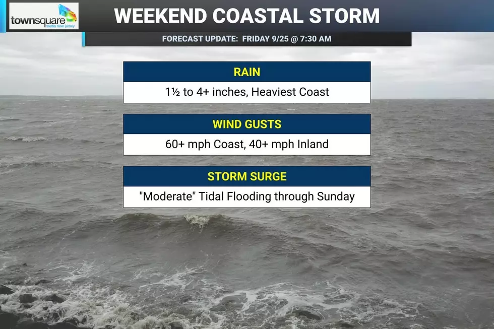
—Rain... Total rainfall estimates have gone up, as the storm track has shifted westward toward the coast. 1.5 to 4+ inches are expected now, with the highest totals along the coast. Flash flooding is a possibility, although that rain will fall over an extended period of time (36 to 48 hours) which will help to mitigate that flooding threat a bit.
—Wind... Wind gusts could reach or even exceed 60 mph along the coast. That is enough to cause power outages, driving difficulties, and some property damage. For inland New Jersey, 40+ mph gusts are possible. Less impactful, but still quite strong.
—Surge... Because of the ongoing strong wind, the full oon, and the coastal flooding we have endured all week, tidal waterways will be running high this weekend. However, storm surge estimates have nudged down slightly, thanks to a more parallel wind direction during the brunt of the storm. Therefore, I think our coastal flooding threat stays in the "moderate" category, rather than ramping up to the "major" category as we feared in a worst case scenario. There will be water inundation issues and road closures surrounding each high tide cycle this weekend, but we should avoid widespread significant property damage.
—Waves... Beaches have been taking a beating this week. 6 to 12 feet ocean waves will continue that trend throughout the weekend. A high risk of dangerous rip currents continues for the foreseeable future.
4.) Warnings and Advisories
A Wind Advisory continues for the coast until 6 p.m. Friday, with gusts to 45 mph. A more severe High Wind Warning then goes into effect from 6 p.m. Friday through 6 a.m. Sunday, calling for potentially damaging 60 mph gusts.
Meanwhile, must of inland New Jersey will fall under a Wind Advisory during that 6 p.m. Friday through 6 a.m. Sunday period. Gusts to 45 mph are possible.
A Coastal Flood Warning continues for the threat of moderate category tidal flooding. There are still no tidal gauges suggesting major flood stage will be reached. Farther upstream, away from major beaches and bays, a Coastal Flood Advisory cautions of repeated instances of minor category flooding.
A High Surf Advisory is in effect until at least Saturday for rough surf, dangerous rip currents, and big 6 to 12 foot ocean waves.
5.) What's Next?
Once the nasty nor'easter clears the coast, weather conditions will slowly improve into Monday afternoon. It will remain pretty cloudy and cooler than normal, with highs in the 60s.
Tuesday should be a much nicer weather day. Skies will turn partly to mostly sunny, the wind will be much calmer, and temperatures finally return to seasonable levels in the 70s.
Beyond that, models show a warmup to 80+ degrees for a couple of days. Just a reminder of the volatility of fall. Don't worry — there will be more storms, more wind, and more chilly days to come.
Be smart and stay safe this weekend. Our team will be on duty and our coverage will continue to keep you informed and secure until the final drops fall and the final gusts blow.
15 common sense flood preparation tips
Gallery Credit: Dan Zarrow
Dan Zarrow is Chief Meteorologist for Townsquare Media New Jersey. Follow him on Facebook for the latest forecast and realtime weather updates.
The complete list of storm names for the 2026 Atlantic Hurricane Season
Gallery Credit: Dan Zarrow

More From 94.5 PST


