
New Jersey, there’s no need to panic over Hurricane Dorian… yet
By now I'm sure you've heard about Hurricane Dorian. Truly an incredible and historic meteorological event. One of the strongest tropical systems ever recorded in the Atlantic basin, with top sustained winds estimated at 185 mph with potential gusts to 220 mph. Over the last day, it has been grinding through the islands of the northern Bahamas.
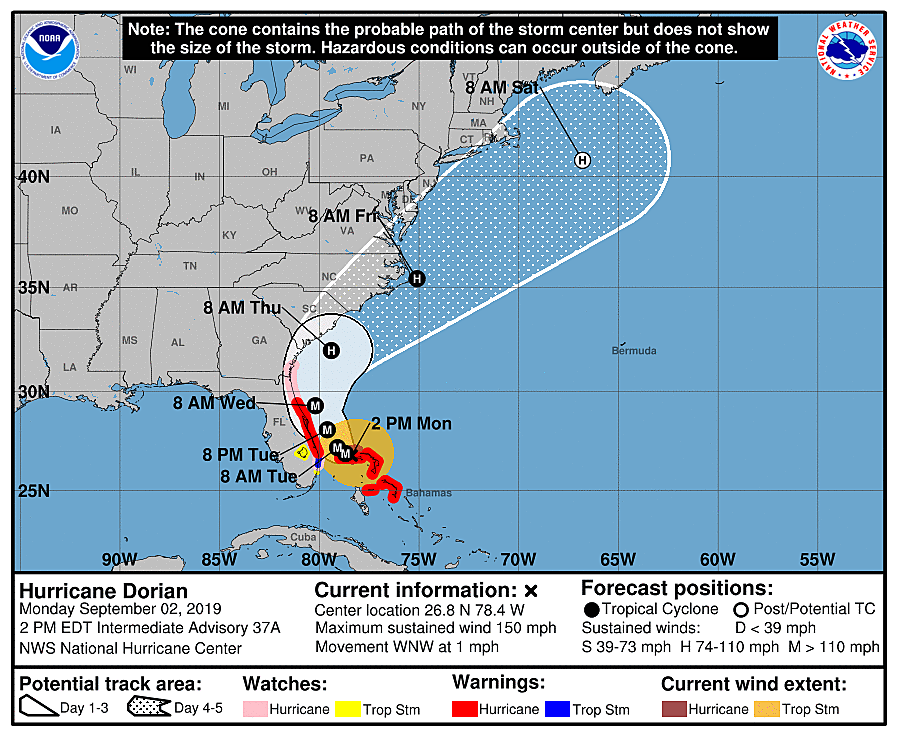
As of 2 p.m. Monday, Dorian is centered just north of Grand Bahama island, about 100 miles east of West Palm Beach, Florida and about 900 miles south of Cape May, New Jersey. Dorian is still classified as a major hurricane, although it has been downgraded to a category 4 storm with maximum sustained winds of 150 mph. The forward motion of the hurricane is negligible, currently crawling to the west-northwest at 1 mph.
The forecast for Dorian has been a beast so far. Just days ago, it looked like the storm would dissipate. Then it slowed down, strengthened significantly, and aimed for Florida. Now, we're expecting Dorian to make a sharp right turn and parallel the Florida, Georgia, and South Carolina coastlines. A direct landfall (of the center of circulation, or eye) is unlikely, but still possible. Even so, tropical rainfall, destructive winds, and storm surge will still be huge problems for the entire southeast coast.
As I said earlier on social media, one little wiggle of the storm track by just a few miles could be the difference between a stiff breeze and hurricane-force winds.
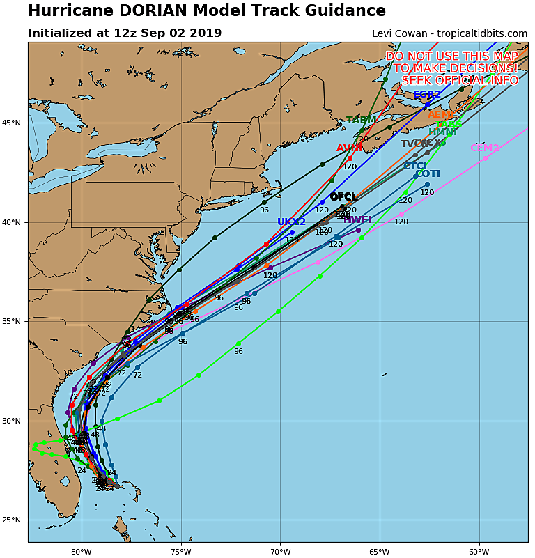
So what's the forecast for New Jersey? It is certainly a precarious situation, as some forecast model runs have pushed Dorian pretty close to the Jersey Shore. But let's not panic. The big picture forecast actually looks pretty good for us, even though New Jersey falls right on the edge of the official National Hurricane Center's forecast "cone of uncertainty". The favored storm track (as of this writing) puts Dorian on a straight northeasterly trajectory as it passes North Carolina. (That's the "out to sea direction".) That would mean little to no rain and wind for the Garden State, but there could be some coastal flooding and beach erosion issues regardless.
Having said that, an unexpected wiggle in the storm track could cause the storm to "hug" the Atlantic seaboard a bit closer. It is possible (although unlikely) that (a much weaker) Dorian ends up near (or right on top of) New Jersey on Friday. At the same time, it is also possible (same probability) that Dorian heads out to sea even earlier than expected.
For now, it's worth watching — New Jersey should remain in wait and see mode for now. There's reason to be optimistic that the storm will miss us. Of course, let's also keep our friends in the Bahamas and Florida and Georgia and South Carolina in our thoughts — we are unfortunately about to see photos and video of truly catastrophic damage and devastation.
That's it for this quick update. I realize there are very few specific forecast details and numbers and timelines in this article. That's on purpose — any potential impacts from Dorian are still about 4 days away. In the world of tropical meteorology, 96+ hours is a long time for things to shift and evolve. My next weather blog post, scheduled to be published by 7 a.m. Tuesday, will have a headline similar to How could Hurricane Dorian affect New Jersey? In it, I plan to give a more precise and specific overview of how our sky and surf could be affected by Dorian later this week.
Dan Zarrow is Chief Meteorologist for Townsquare Media New Jersey. Follow him on Facebook or Twitter for the latest forecast and realtime weather updates.
More From 94.5 PST


