NJ weather: Three rounds of storms then a dry, comfortable weekend
The Bottom Line
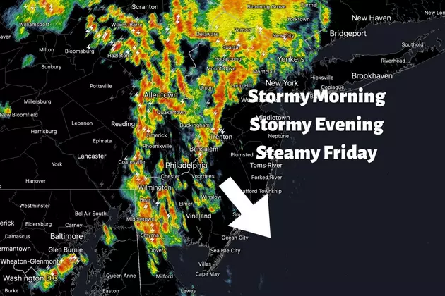
Showers and thunderstorms are already arriving in New Jersey Thursday morning. So, for the second time this week, you'll have to battle some stormy weather during the AM rush.
Another round of wet weather is likely Thursday evening, with some pockets of heavy stuff possible.
And then, following a hot and humid day Friday, a few spot storms will accompany a strong cold front.
The end result, this weekend, will be cooler, more comfortable, completely dry weather. But will it be too cool and too breezy for part of the weekend?

Thursday
As of this writing (6 a.m.), showers and thunderstorms are arriving in western and northwestern New Jersey. This cluster of storms really blossomed overnight over Pennsylvania and Central New York. And now it looks like everyone in New Jersey will get wet.
So grab the umbrella to start the day. These morning storms are producing pockets of very heavy rain and a lot of lightning. Storms should fizzle a bit as they travel from northwest to southeast across New Jersey. They'll exit the coast by about 10 or 11 a.m.
Through the midday and afternoon hours, we'll dry out. It will be cloudier than Wednesday, with some breaks of sun hopefully. High temperatures will be cooler than Wednesday, in the mid to upper 70s. (A hair below normal for mid June.) Humidity levels will be slightly higher than Wednesday, as dew points push into the sticky 60s.
Our next batch of rain will arrive Thursday evening, between about 8 p.m. and 2 a.m. Once again, some local downpours, vivid lightning, and even gusty winds are possible.
Beyond the stormy weather, it will be mostly to partly cloudy and somewhat muggy overnight. Low temperatures will only dip into the upper 60s by daybreak Friday.
Friday
It has been an excruciatingly sultry, steamy week across the southeastern United States. And on Friday, New Jersey will get a taste of that hot air. It will be our 6th 90+ degree day of the year.
Highs will push into the lower 90s on Friday, with a stiff "blast furnace" southwesterly breeze. That land breeze will keep even the beaches toasty. (Barrier islands, surrounded by water on all sides, excludes.)
Eventually, a cold front will push in. That's the leading edge of cold air. And a source of lift for potential thunderstorms.
Most likely timing for front and strong storms now looks to be mid to late Friday afternoon. Model guidance still keeps thunderstorm chances minimal — isolated to spotty, at the most. But given the heat and humidity, instability will be very high. So if a storm is able to pop, it will become strong to severe very quickly. Keey an eye on the sky late Friday, please.
Saturday
Behind Friday's spotty storms and cold front, temperatures and especially dew points will tumble. By Saturday morning, thermometers will be close to 60 degrees. Dew points will be in the basement, probably in the bone-dry 40s.
So the weekend will turn cooler and more comfortable. And it will be completely dry.
Saturday's forecast reads as follows: Partly to mostly sunny. Breezy to windy. High temperatures around 70 degrees.
70 is much more "springlike" than "summer-ish," running about 10 degrees below normal for mid June. And that wind may kick over 25 mph at times. It will still be a nice day, with lots of sunshine and not a drop of rain around. I'm just wondering if it'll be too cool for any beach and pool plans. Especially once the sun starts to set.
Sunday
Sunday's temps will still hover about 5 degrees below seasonal normals. But with lighter winds, abundant sunshine, dry air, and dry weather, it should be a beautiful day. Look for highs in the mid 70s.
The Extended Forecast
Next week is one of the most important of the year here in the weather center, with high school graduation season in full swing.
Monday looks good, with increasing clouds and highs near 80.
But then our weather turns unsettled again through the middle of next week. I can't dive into specifics yet, as models show a wide spread of possible scenarios. Ranging from persistent scattered rain from Monday night through Thursday morning, to just a few storms on Tuesday and Wednesday. Temperatures will depend on how much rain we get and how thick the clouds are, but we should hold at or below normal (mainly 70s) throughout.
Dan Zarrow is Chief Meteorologist for Townsquare Media New Jersey. Follow him on Facebook or Twitter for the latest forecast and realtime weather updates.
NJ speaks: What is the end of a loaf of bread called?
Gallery Credit: Dan Zarrow
More From 94.5 PST


