
NJ’s first of two winter storms this week: 0-3″ of snow, wintry mix
The Latest Developments
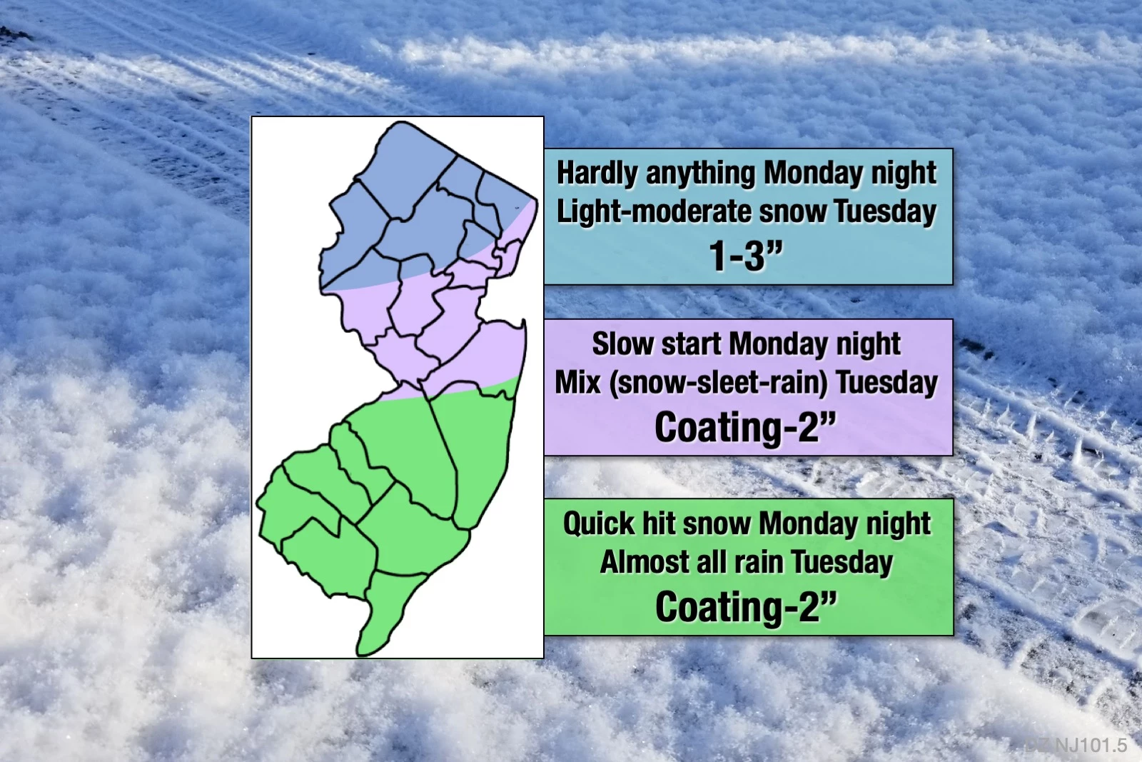
For the most part, I'll let the map do the talking here. It is shaping up to be a (somewhat) wintry week for New Jersey. Our weather is definitely turning more active than it had been over the last three weeks.
UPDATE... This article is outdated...
For the latest winter storm forecast information, please refer to my newest weather blog post.
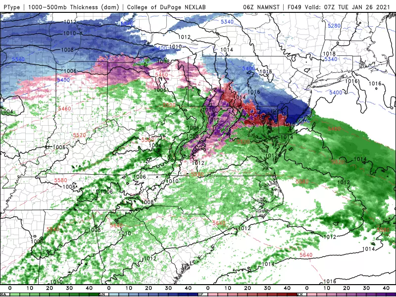
It is becoming very clear that the Monday night-Tuesday storm system will face several struggles on its journey through the Garden State.
The first is one that happens in every winter storm: Temperatures, both at the surface and aloft (up in the atmosphere). This is not going to be an "all snow" event for central and especially southern New Jersey. Any mixing with sleet and/or rain will strictly limit accumulations.
Poor dynamics will make for a weaker storm. While the initial impact Monday night could be quite wintry, it's going to get torn apart by the time the second and third waves arrive during the day Tuesday.
Very dry air will also build a wall around North Jersey, in particular. It's going to take a while for the atmospheric column to moisten up enough for snowflakes, ice pellets, and/or raindrops to fall. Possibly not until daybreak Tuesday.
How's forecast confidence? Eh, it's OK. (No forecast is complete without a measure of confidence, or certainty.) In this case, forecast models are all telling the same basic story — an unimpressive, but still potentially impactful, wintry mess from Monday night to Tuesday. But the details are weird, for lack of a better term. The main differences have to do with precipitation type (in South Jersey) and dry air (in North Jersey). That is reflected in my forecast map.
Timeline
Initial precipitation is expected to bubble up into southwestern New Jersey around 6 p.m. Monday. (That means we'll escape the daytime hours on Monday problem-free.) Temperatures are going to be right on the line at onset. And there is significant model disagreement about whether that initial band will be rain or snow for South Jersey. (I am leaning toward a quick burst of winter.)
During the overnight hours, precipitation will struggle to reach north of Interstate 195.
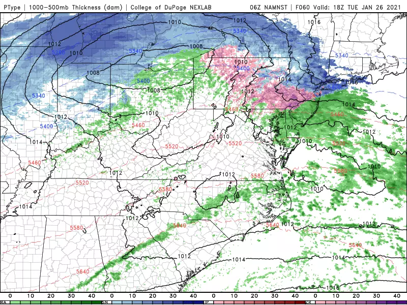
Beyond daybreak Tuesday, precipitation type will fall in line with the map above. All snow to the north. A slushy mix of snow, sleet, and rain in the middle. And all rain to the south. While there could be heavier bursts in precipitation intensity during this time, it's going to mainly light and even showery stuff during the day.
It's hard to declare a "brunt" of the storm, when the heaviest stuff is expected to fall. But Tuesday morning does look potentially challenging, given the wide variety of (and rapid changes in) precipitation types at that time.
Things will gently taper off Tuesday night, ending completely by daybreak Wednesday at the latest.
Accumulations
Again, please refer to my snow map above for a visual interpretation of what to expect. The most reasonable outcome from this storm is "an inch or two" of snow/slush accumulation across the state. A little more to the north, perhaps. A little less to the south.
As I mentioned, South Jersey could pick up that quick inch or two of snowfall right off the bat, as the storm system moves in Monday night. Then a flip to rain, rain, rain on Tuesday will turn any snow to slush.
Meanwhile, the "cold zone" of North Jersey looks to slowly accumulate upwards of 3 inches during the day Tuesday.
In the middle, totals are difficult to determine, since we could have snow, sleet, or rain (or all three) falling at any given time on Tuesday. I'm satisfied with my half-inch to 2" forecast between about I-195 and I-78, as I could see scenarios where either end of that range verify.
By the way, I had previously suggested that locally higher amounts up to 6 inches would be possible somewhere in the state. And I wouldn't rule out heavier snow bands forming, if conditions are perfect. But I want to stress again that I am leaning toward rather light, unimpressive snowfall here overall.
Impacts
Despite the meager, slow accumulation numbers, I do have three concerns when it comes to how this storm will impact New Jerseyans:
1.) As you may have noticed, it's very cold outside this weekend! The ground will be nice and frozen as our storm arrives Monday night. That means snow will begin to accumulate quickly.
2.) The cold ground and flip-flopping precipitation types also increases the likelihood of icing. Initial rain could freeze on contact with cold surfaces, known as freezing rain. I don't think we're facing a full-on "ice storm," but it only takes a light glaze of ice to make travel conditions hazardous.
3.) Both Tuesday morning's and Tuesday afternoon's rush hours could be affected by something wintry falling from the sky. Reduced visibility and slushy/icy roads can be problems even in the most minor winter storm event. (For the record, I don't think we're facing a disastrous ride like #Brinegate in November 2018.) You will want to exercise the usual common sense, extra caution, and extra time rules. I wouldn't be surprised to see some school delays and even closures on Tuesday.
As we've discussed previously, wind, extreme cold, and coastal flooding are not expected to be issues with this storm.
The 2nd Storm
Thursday's forecast is a mess.
Yes, there's a good chance another storm brushes New Jersey from the south. Yes, it's going to be stronger and more moisture-rich. Yes, it has the potential for even heavier snowfall than the first storm, particularly in South Jersey.
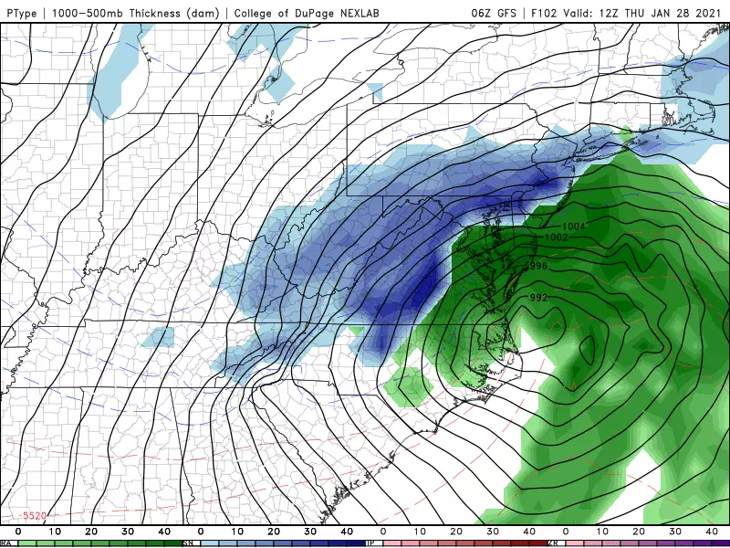
But forecast models (both operational and ensemble) are still doing an awful job handling this second storm. We're nowhere near ready to put numbers on this thing. And I doubt that will happen until Tuesday, at the earliest.
The next next opportunity for a storm would be early next week in the Monday-Tuesday time frame.
That it for this Sunday morning edition of the CMDZ weather blog. If there are any significant changes to this forecast, I will update again Sunday afternoon. Otherwise, I'll see you again online and on the radio dark n' early Monday morning.
Dan Zarrow is Chief Meteorologist for Townsquare Media New Jersey. Follow him on Facebook or Twitter for the latest forecast and realtime weather updates.
KEEP READING: See the richest person in every state
KEEP READING: Here are 50 of your favorite retail chains that no longer exist
More From 94.5 PST


