
Zeta’s finale: Rain, snowflakes, coastal flooding, and a freeze
Over the past 24 hours, we've had rainfall totals near 3 inches (SE NJ) and wind gusts over 40 mph (coast). And we're not quite done with the miserable weather yet, as one more round of rain passes through the Garden State Friday morning. That will be followed by the coldest air of the season so far, by far.
Let's examine each of our remaining sky/surf impacts, one by one:
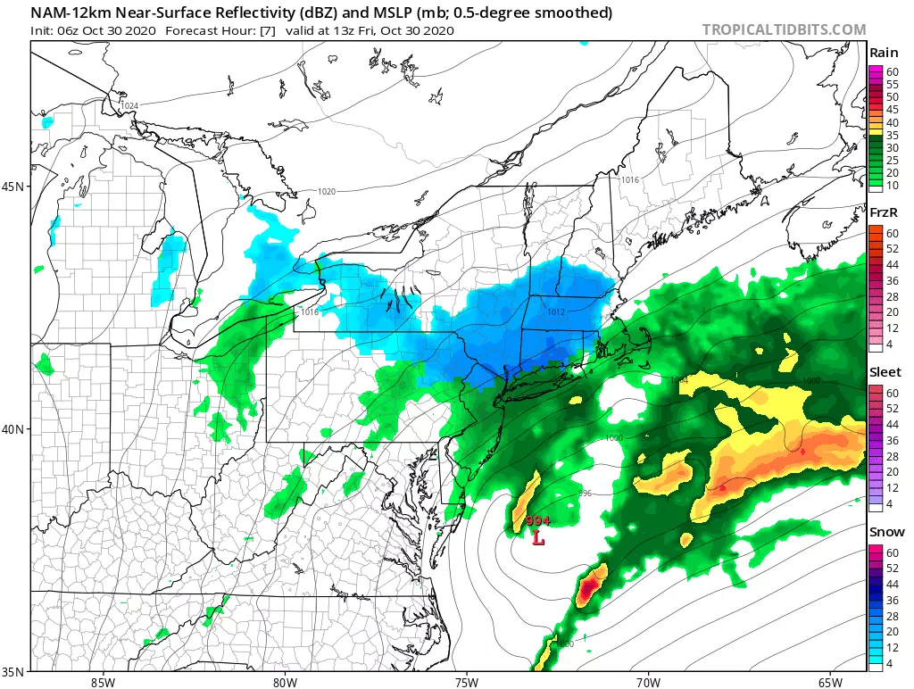
One More Round of Rain
It's. Still. Raining. Following a relative lull in the wet weather overnight, we once again have steady rain covering the state. This final round will start to break up around 10-11 a.m. I suspect New Jersey's last raindrops will fall around 1-2 p.m. (Although keep in mind, there are a few solutions that keep a chance of isolated showers over NJ until about 6 p.m. Friday.)
Additional rainfall may approach an inch. Since the ground is already thoroughly saturated, ponding and flooding could occur during the AM commute. The large volume of leaves on the ground may also clog storm drains. As you probably noticed on Thursday, visibility will be severely reduced during moderate to heavy rainfall.
Some Snowflakes
As of this writing (5:30 a.m.), temperatures have dropped as cold as 34 degrees in North Jersey (at the top of High Point, elevation 1765 ft). So yes, we are aiming for the first snowflakes of the season in North Jersey. I'm still thinking a period of snow is likely north of Interstate 80, and possible as far south as Interstate 78.
Best chance would be the higher elevation areas of Sussex, western Passaic, and Morris counties. Best timing for the snow would be between 6 a.m. and 11 a.m. While some models have suggested the possibility of light accumulation (on the order of an inch or two), the ground will be two wet and relatively warm to sustain much.
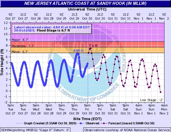
Coastal Flooding
The gusty northeasterly winds overnight have driven water toward the Jersey Shore. An extra 2 feet of ocean water is expected to cause widespread minor to localized moderate category flooding of tidal waterways. (Guidance shows tide levels getting within a couple inches of moderate flood stage — that's where flooding goes beyond "the usual spots." Friday morning's high tide cycle occurs around 7 a.m. along the oceanfront, and up to several hours later on back bays and tributaries.
Subsequent high tides should be much lower. But I wouldn't rule out minor flooding in particularly vulnerable spots. The next oceanfront high tide will be in the 7 p.m. hour Friday evening.
Freeze
The remnants of Zeta helped to drag down some cold air, ultimately leading to the first widespread freeze of the fall season Friday night. Low temperatures will range from the upper 20s (NW and Pine Barrens) to lower 30s. I think everyone in the state is subject to feel freezing temperatures early Saturday morning, except urban and coastal areas.
Gardeners and farmers, your sensitive plants will not like this cold.
The Extended Forecast
Halloween (Saturday) will be mostly sunny, calm, and dry. But trick-or-treaters will want to wear an extra layer or two under the costume, with a high temperature only in the upper 40s or so. In case you're keeping score, that would make it New Jersey's coldest Halloween since 1993! (I was in elementary school at the time — I think I dressed up as a wizard that year?)
Sunday morning looks more like a limited frost, rather than a freeze. And temperatures will moderate to around 60 degrees later Sunday. It will be a mostly cloudy and breezy day. And an approaching cold front will fire off some rain too. Best chance of scattered rain looks to be Sunday late afternoon to early evening.
Behind that front, another blast of cold air will arrive via a strong northwest wind. Gusts from Sunday night to Monday to early Tuesday may exceed those from Zeta's remnants, peaking between 40 and 50 mph. And with high temperatures only in the 40s Monday afternoon, it will be a blustery "bundle up" kind of day. At least skies will be partly sunny and dry.
Lower 50s and windy Tuesday. Mid 50s, calm, with sunshine on Wednesday. And then I'm optimistic we'll finally see a return to seasonable temperatures on Thursday, with highs in the lower 60s.
More From 94.5 PST


