Isaias update: Peak rain and wind will most likely hit NJ on Tuesday
Happy August. We continue to closely monitor Hurricane Isaias, as it churns through the Bahamas Saturday and aims for the Florida coast on Sunday. If you're sick of hearing about this hard-to-pronounce storm, there's unfortunately a lot more ees-ah-EE-ahs to come.
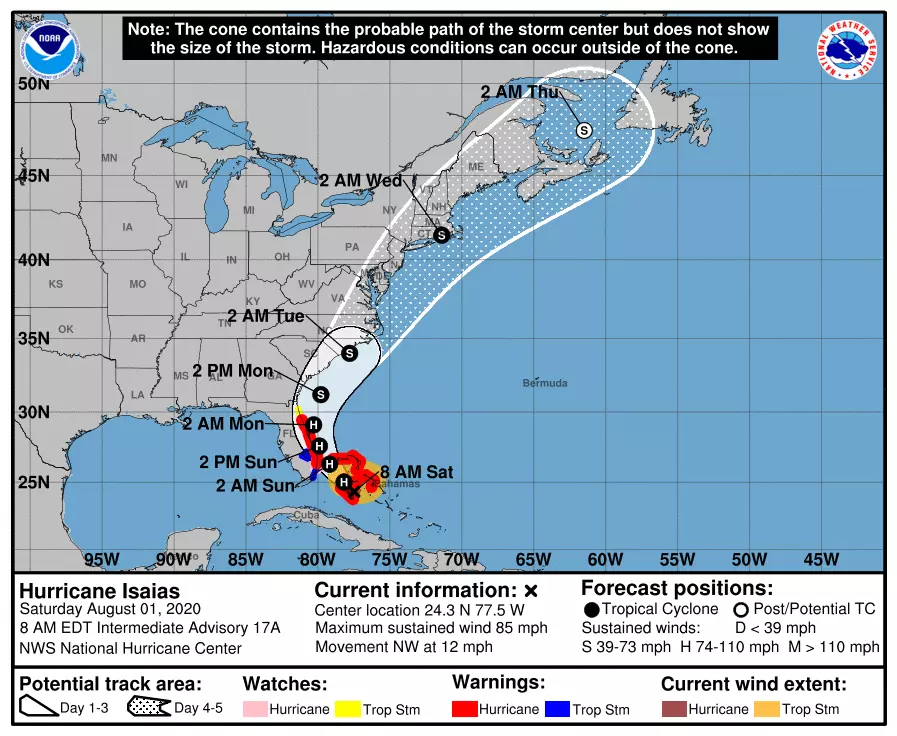
The forecast is slowly becoming clearer. And it's still potentially ominous. At this point, the storm appears to have little to no opportunity for a complete "escape route" from the U.S. East Coast. In other words, it is now highly likely that New Jersey faces at least some rain, wind, surf, and/or surge impacts from Isaias within a few days.
But the details of Isaias's approach are still tricky. As of this writing (9 a.m. Saturday), we are still about 60 hours away from first raindrops and 72 to 84 hours away from the biggest impacts. That leaves plenty of time for the track to wiggle and for any of the zillions of pieces in this meteorological puzzle to change.
Where is Isaias Now?
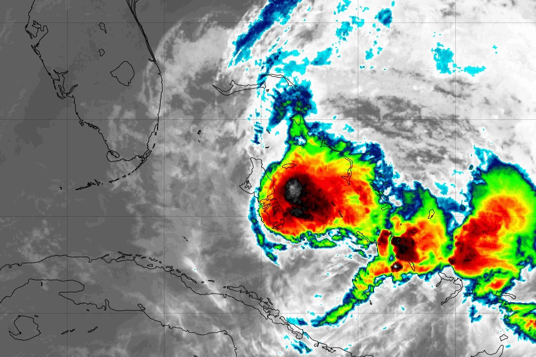
As of 8 a.m. Saturday, Isaias was officially centered 50 miles south of Nassau, Bahamas or about 1,020 miles south-southwest of Cape May, N.J. It strengthened overnight, now packing maximum sustained winds of 85 mph. (Still a category 1 hurricane.)
Isaias's outermost clouds have now reached southeastern Florida, in the Miami area, where a Hurricane Warning is in effect. It is a compact storm, with 75 mph hurricane force winds only extending 30 miles from the center. (39 mph tropical storm force winds have a radius of 150 nautical miles on the northeast side of the hurricane.)

What We Know
1.) The timing of the storm's progression is becoming clearer. Peak rainfall, wind, and waves should arrive in New Jersey on Tuesday. (See below for a more detailed timeline)
2.) Over the past day, the storm's forecast has become slightly slower and weaker, mainly because the track is drifting closer toward the coast. As Isaias passes New Jersey, it will likely be at tropical storm strength. Still, nothing to sneeze at.
3.) A "coast hugger" track, where the center is located just along or just east of the Jersey Shore would be our worst case scenario. Rain, wind, and surge would all be significant problems. If the storm "wiggles" west (left), rain and flooding would become our primary concern. If the storm "wiggles" east (right), moderate wind and surge would be the focus.
What We Don't Know
1.) Yet again, Isaias strengthened and none of our forecast models picked up on it. That leads me to believe we're not getting a complete or totally accurate picture of the storm and atmosphere from model guidance.
2.) How much rain, how much wind, and how much surge. I realize these numbers are an incredibly part of the forecast. But they are highly dependent on the exact track, size, and strength of Isaias. It's still early, especially considering point #1.
Forecast Timeline
—Now... The ocean is already getting rough. A Moderate risk of rip currents is posted for the Jersey Shore Saturday, as Isaias churns up the Atlantic. Surf will only get rougher Sunday into Monday.
—Late Monday (after 4 p.m.)... Showers and thunderstorms are possible, largely unrelated to Isaias. Generally unsettled, wet, and humid Monday night.
—Tuesday... Prime time for New Jersey. Tropical rainfall, strong winds, storm surge, and big ocean waves are possible throughout the day. (Maybe extendeding into Tuesday night.) High tides along the oceanfront will occur around 9 a.m. and 9 p.m. A nasty day.
—Wednesday... There may be residual showers through the morning. It will still be breezy. And the ocean will remain rough for a few days. But our latest forecast calls for mostly sunny skies and high temperatures in the mid to upper 80s. A beautiful day.
Probable Impacts for NJ
It's still difficult to piece together a detailed forecast for New Jersey, with countless track forecasts and scenarios still on the table. In other words, forecast confidence remains low. But I know you want (and in some cases need) this information, and I like being straightforward and honest with you, so here's my latest thinking.
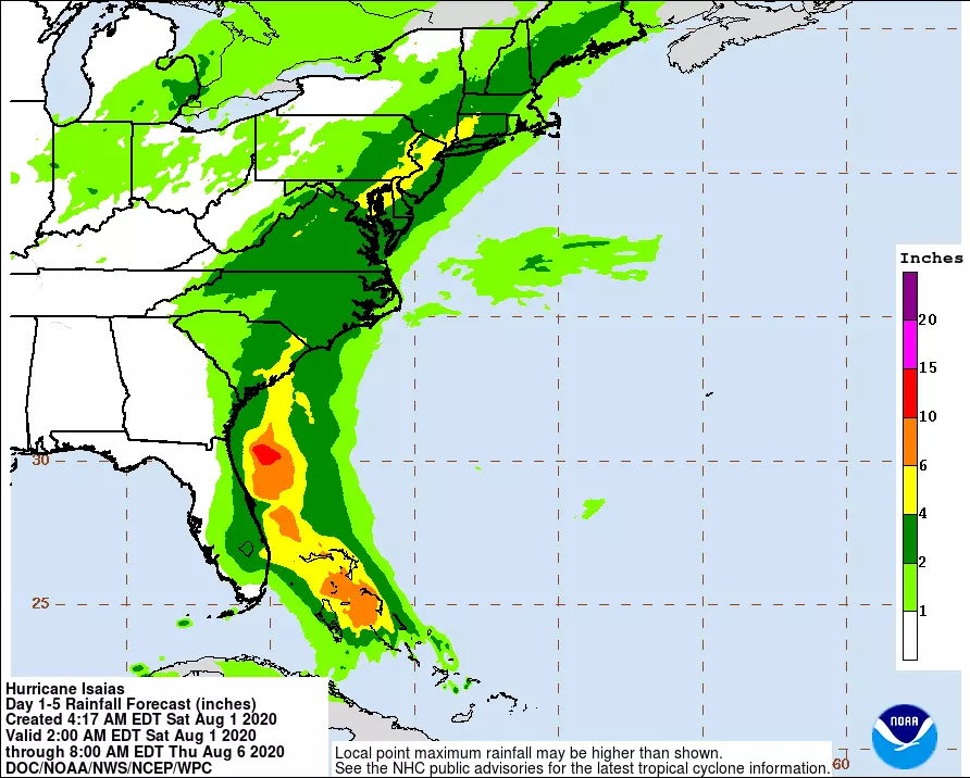
—Rain... There is literally no solution on the table at this point that includes zero rainfall for New Jersey. I think top totals on the order of 3+ inches are likely at this point. Worst case would include some spots with 5 to 6+ inch rainfall, causing widespread flooding.
—Wind... Probably the biggest question mark here, as this forecast involves balancing the strength, track, and orientation of the storm. It's possible that wind is not a huge factor, especially if the storm takes a more inland path. But I'm thinking gusts in the 30+ mph (inland) to 50+ mph (coast) range are a reasonable expectation. If the eye wall brushes past the Jersey Shore, those estimates would be too low.
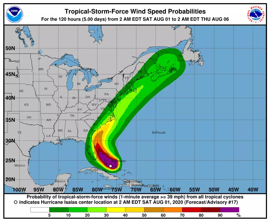
—Surge... Since the storm timeline has shifted later, we still don't have reliable model guidance on the degree of potential storm surge and coastal flooding. My back-of-the-envelope estimate puts most likely surge in the 1 to 2 foot range on Tuesday, which is enough to cause minor to moderate flooding of tidal waterways. A more inland track would mitigate the flooding threat considerably.
—Surf... Yikes. I've seen max wave height forecasts ranging from 8 to 16 feet just off the Jersey Shore. A violent surfmaker could contribute to coastal flooding (especially on barrier islands), and also cause significant beach erosion. Remember, the elevated rip current risk and angry ocean has already begun.
What's Next?
I still don't think you need to necessarily do anything to prepare for the storm at this point. Maybe formulate a plan if the worst case scenario comes to fruition, especially if you live near the coast. If a tropical storm watch is issued — probably Sunday morning — that's when it's time to secure your property, check your supplies, and make adjustments to your Tuesday routine to remain safe and sound.
Unless something changes dramatically, my next weather blog will be published sometime Sunday morning.
Until then, enjoy this spectacular summer Saturday.
Dan Zarrow is Chief Meteorologist for Townsquare Media New Jersey. Follow him on Facebook or Twitter for the latest forecast and realtime weather updates.
More From 94.5 PST